December 4, 2023
Posted by Meteorologist Beau Dodson
Welcome to Monday! I hope you had a nice weekend. Not too bad for the first week of December.
We do have a fast-moving clipper like system moving through the region this morning. Had it been a few degrees colder, then some locations would have picked up a dusting to an inch or two of snow.
Snow lovers can dream, I guess!
It was rain. A few reports of graupel were received, as well. Graupel is sort of like sleet. A sleet/snow like pellet.
Rain totals have been mostly in the 0.00″ to 0.05″ range. A few spots picked up a bit more than that.
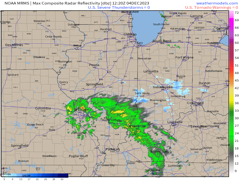
Radar showed the system pivoting through the region.
Here was a 7:30 am radar animation. See the live radars for the latest view. LINK to the live radars. CLICK HERE
Another fast-moving weak system will move across the region tonight and tomorrow. Perhaps one or two light showers will accompany it, as well. Mainly over Illinois and Kentucky. Same as this current system.
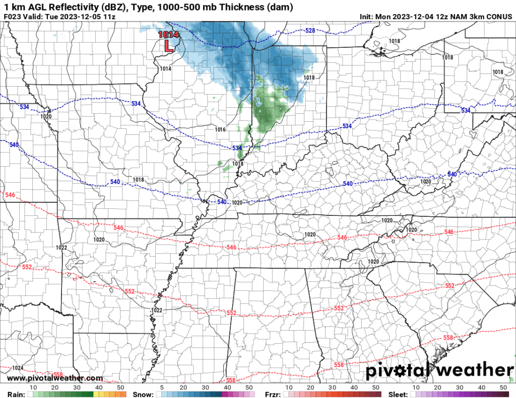
The NAM model shows a few light showers in the region tomorrow morning. Green is rain. Blue is snow. This is the NAM model future-cast radar for 5 AM tomorrow morning.
It shows a few more showers during the afternoon over mainly southeast Illinois and Kentucky.
Dry conditions are expected Tuesday evening through Friday afternoon.
It will be a windy week. Numerous days and nights will have 10 to 20 mph winds. Occasionally, we will also have rounded of 20 to 30 mph winds. Gusty.
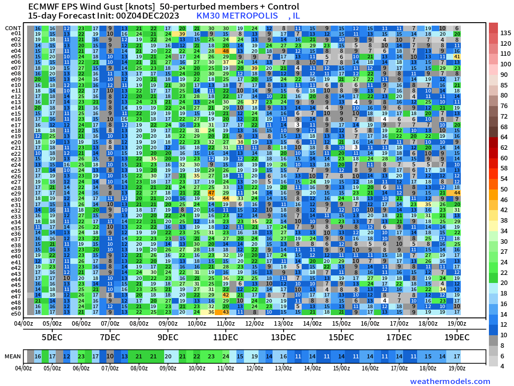
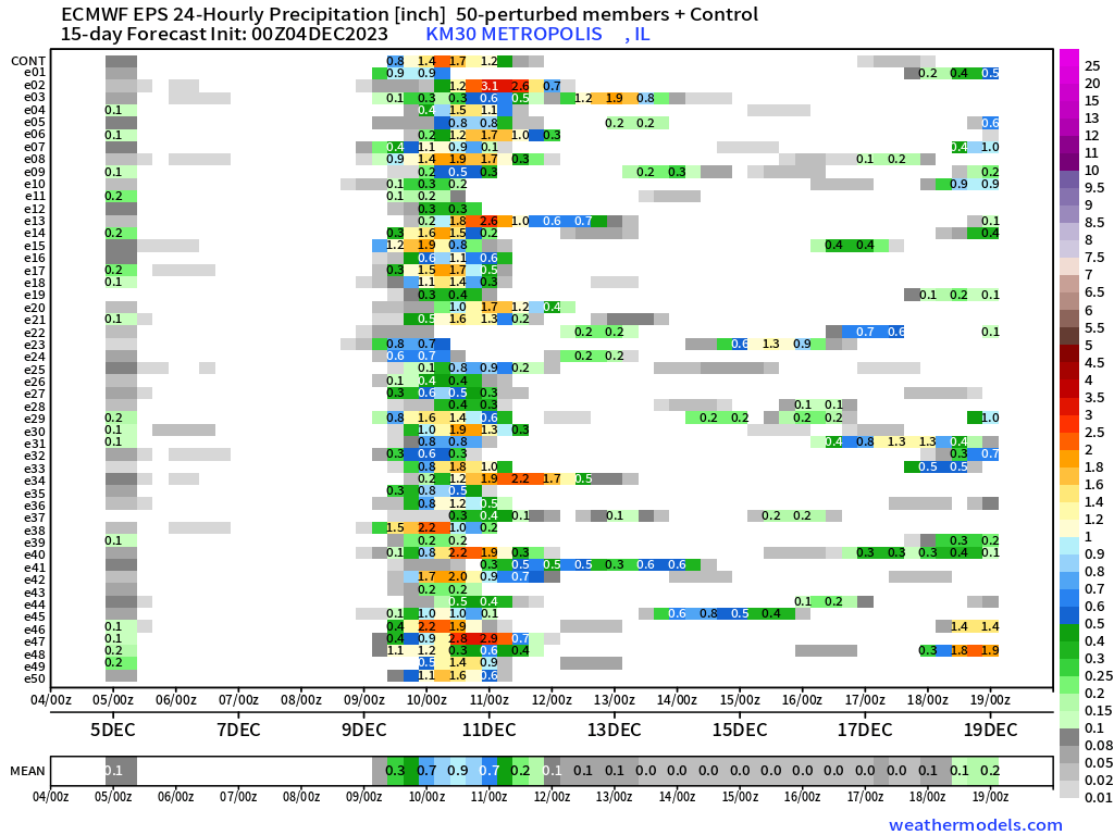
Here is the wind matrix from the EC model. This is the same model (EC) ran 50 times. Each time they begin it with slightly different variables. The idea is the model squares that equal the same number, the higher the confidence in the forecast.
The date is located along the bottom (horizontal row). The model run number is on the left side of the graphic (vertical).
Notice the first vertical row is mostly 10 to 20 mph wind gusts. That means there is a high confidence that today’s winds will gust between 10 and 20 mph.
Notice the strong clustering of green at 00z December 6th? That is 6 PM December 5th (we are using Zulu time). All of those green colors equal a high confidence forecast in a windy night.
That would be the night of December 5th and morning of December 6th. A lot of 24 to 28 numbers. That would be 24 to 28 mph wind gusts.
Notice all the green colors 08/00 to 11/00? That would be the night of December 7th through the night of December 10th. Several days of winds gusting into the 20 to 30 mph range.
Overall, a windy week ahead of us.
We can use the same type of chart to find where the highest rain chances will occur.
As you can see, that would be centered on Friday night through Sunday.
Our weekend system could bring severe weather close to the region. For now, the Storm Prediction Center has placed portions of Texas, Arkansas, Louisiana, and Mississippi in a risk zone.
Adjustments are possible. I am closely monitoring the front and placement of the low-pressure center. When the low tracks to our west and north, it places us in the unstable airmass. When a system passes to our south, we are on the cold side of the event.
Typically, severe weather occurs south and east of the track of the area of low pressure.
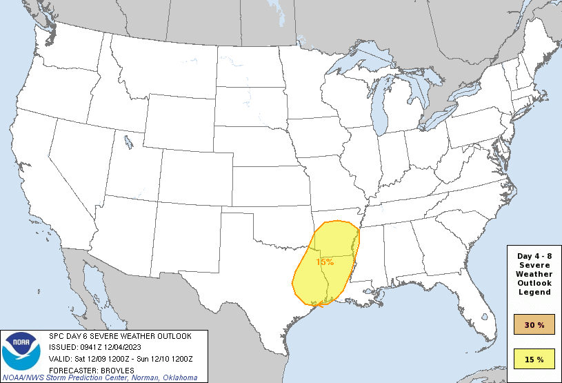
I will be keeping a close eye on the weekend storm system.
What about snow and ice?
For now, I have the bulk of the snow and ice staying to our north and west. Occasionally, the EC model shows snow farther south and east. Closer to our region.
For now, the chance of snow and ice appears minimal. I will closely monitor trends over the coming days.
If the system were to shift south and east, then we would have to look at snow and ice chances.
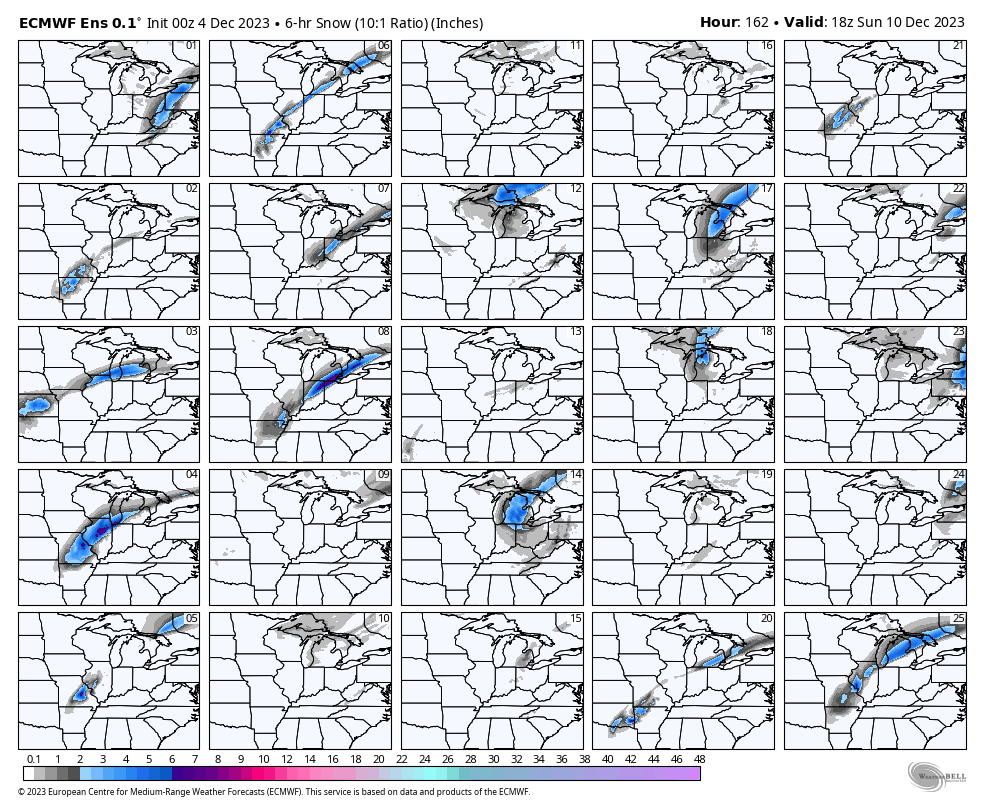
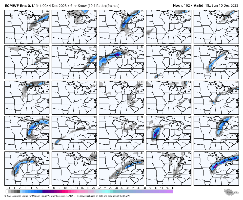
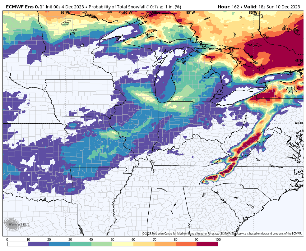
Let me show you the EC ensembles. This is what it is forecasting snow-wise. Again, ensembles are where they run the model over and over again. With slightly different beginning variables.
The idea is that the more squares that agree, the higher the chance of the eventual outcome. If 40 out of 50 squares show snow, then the chance of snow is high. If a handful of squares show snow and ice, then confidence in snow and ice would be low.
As you can see, a few of the squares get close to our area. The bulk of the squares, however, are showing the snow and ice staying just outside our local area.
The mean of all of those squares shows the following. What is the probability of 1″ or more of snow through Sunday night?
Low end chances over mainly southeast Missouri and southern Illinois.
For now, plan on shower and thunderstorm chances increasing Friday night into Sunday. Perhaps lingering into Sunday night. High probability chances.
The rain might end as snow over our western and northern counties. Confidence in that, however, is low.
Stay tuned.
Want to receive more weather information?
Regional videos, long range weather videos, daily blog updates, hand typed forecasts from my keyboard to the Beau Dodson Weather app, severe weather alerts, ice storm warnings, and more!
Subscribe at www.weathertalk.com and then download the Beau Dodson Weather App from the app store.