HIT THE FACEBOOK AND TWITTER SHARE BUTTONS.
You will need to hit the REFRESH button to see the most up to date post.
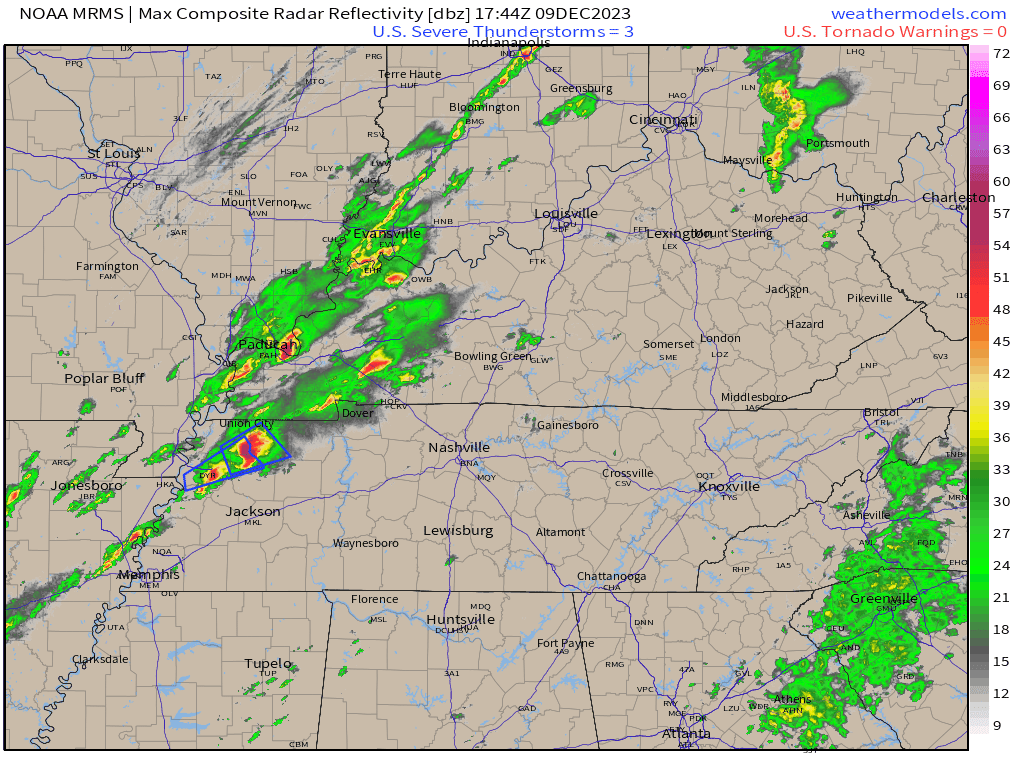
3 PM
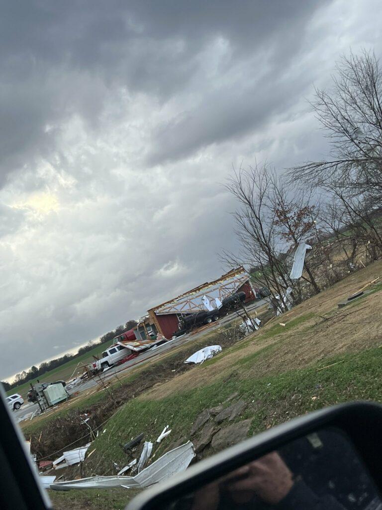
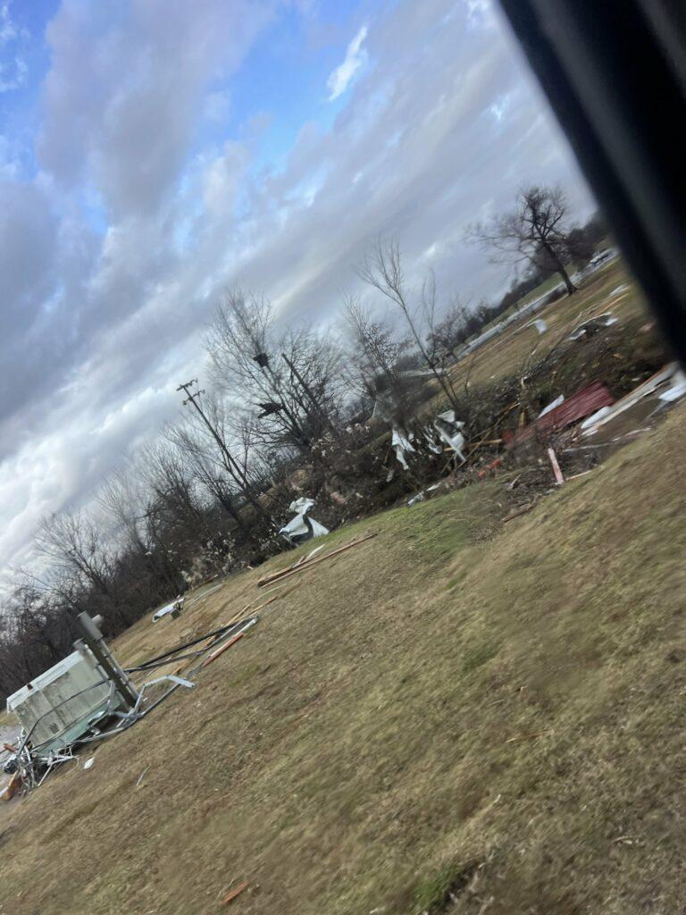
Thoughts and prayers to everyone who has been hit by tornadoes. Please avoid damage zones. Emergency responders are in search and rescue mode. There has been extensive damage in many areas of northwest Tennessee into south-central/western Kentucky.
2:37 PM
Severe Weather Update
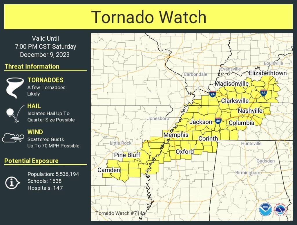
The threat of severe weather has ended. The tornado watch has been cancelled for all but Muhlenberg and Todd Counties. We continue to watch a few storms in Tennessee.
The rest of the area can go about their afternoon and evening activities.
Several tornadoes touched down in northwest Tennessee and western Kentucky. There is quite a bit of damage in some areas. Please avoid damage paths. Emergency crews are in the process of search and rescue.
2:31 PM
The threat of severe weather has ended for my forecast area. I am waiting on the NWS to cancel some of the tornado watch.
I will post more shortly.
2:11 PM
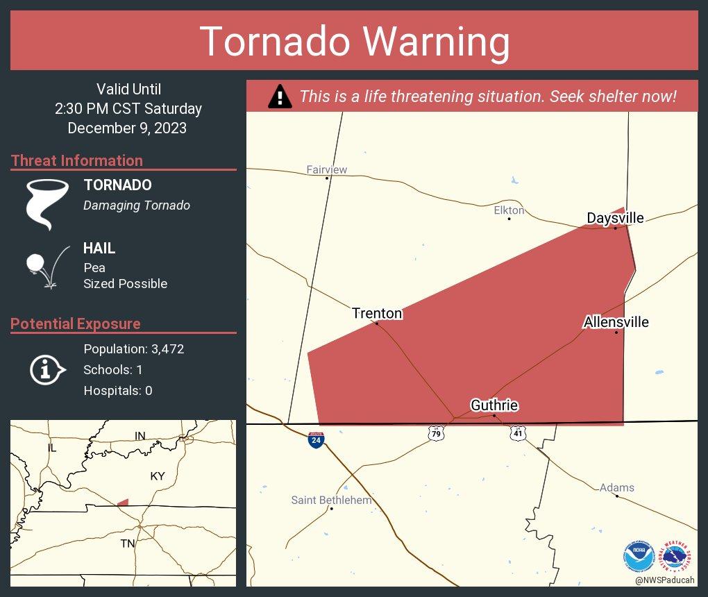
217 PM CST Sat Dec 9 2023
…A TORNADO WARNING REMAINS IN EFFECT UNTIL 230 PM CST FOR
SOUTHEASTERN TODD COUNTY…
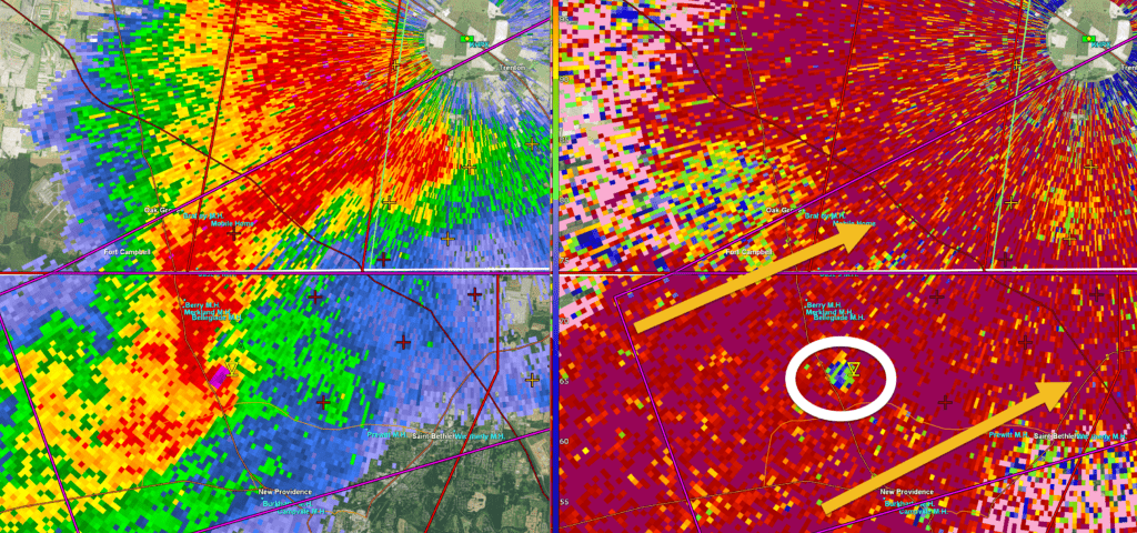
At 216 PM CST, a confirmed large and extremely dangerous tornado was
located near Allensville, moving northeast at 45 mph. Allensville is
going to be directly impacted by this tornado.
This is a PARTICULARLY DANGEROUS SITUATION. TAKE COVER NOW!
HAZARD…Damaging tornado.
SOURCE…Radar confirmed tornado.
IMPACT…You are in a life-threatening situation. Flying debris may
be deadly to those caught without shelter. Mobile homes
will be destroyed. Considerable damage to homes,
businesses, and vehicles is likely and complete destruction
is possible.
This tornadic thunderstorm will remain over mainly rural areas of
southeastern Todd County, including the following locations…
Allensville.
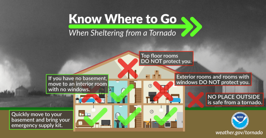
PRECAUTIONARY/PREPAREDNESS ACTIONS…
To repeat, a large, extremely dangerous and potentially deadly
tornado is on the ground. To protect your life, TAKE COVER NOW! Move
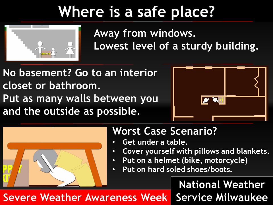
to a basement or an interior room on the lowest floor of a sturdy
building. Avoid windows. If you are outdoors, in a mobile home, or in
a vehicle, move to the closest substantial shelter and protect
yourself from flying debris.
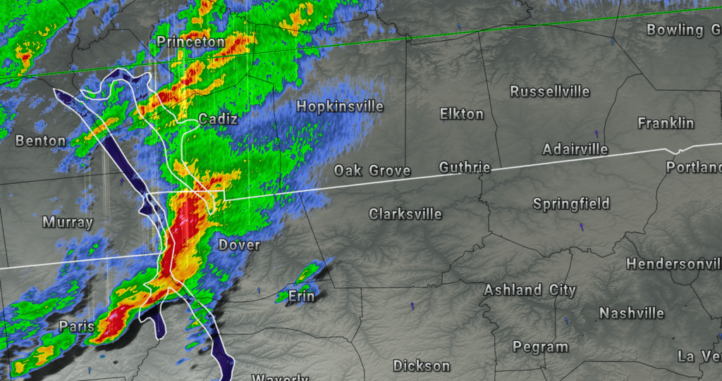
Allensville, Kentucky is about to be hit by a tornado. Stay sheltered.
2:08 PM
Tornado remains on the ground in southern Todd County north of Guthrie. Moving northeast at 60 mph. Stay sheltered until this storm has passed the county.
2:00 PM
Tornado warning cancelled for Christian County.
A tornado is on the ground in southern Todd County, Kentucky doing damage. This is a dangerous storm and has a history of damage.
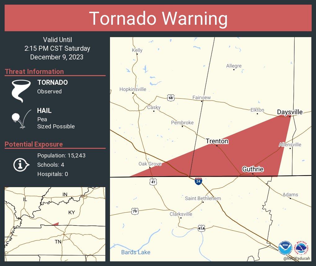
Tornado Warning
National Weather Service Paducah KY
159 PM CST Sat Dec 9 2023
The National Weather Service in Paducah has issued a
- Tornado Warning for…
Southern Todd County in south central Kentucky… - Until 230 PM CST.
- At 159 PM CST, a confirmed large and extremely dangerous tornado
was located 4 miles west of Guthrie, or 8 miles northeast of
Clarksville, moving northeast at 40 mph. This is a PARTICULARLY DANGEROUS SITUATION. TAKE COVER NOW! HAZARD…Damaging tornado. SOURCE…Radar confirmed tornado. IMPACT…You are in a life-threatening situation. Flying debris
may be deadly to those caught without shelter. Mobile
homes will be destroyed. Considerable damage to homes,
businesses, and vehicles is likely and complete
destruction is possible. - The tornado will be near…
Guthrie around 205 PM CST.
PRECAUTIONARY/PREPAREDNESS ACTIONS…
To repeat, a large, extremely dangerous and potentially deadly
tornado is on the ground. To protect your life, TAKE COVER NOW! Move
to a basement or an interior room on the lowest floor of a sturdy
building. Avoid windows. If you are outdoors, in a mobile home, or in
a vehicle, move to the closest substantial shelter and protect
yourself from flying debris.
1:55 PM
Severe Thunderstorm Warning
National Weather Service Memphis TN
152 PM CST Sat Dec 9 2023
The National Weather Service in Memphis has issued a
- Severe Thunderstorm Warning for…
Benton County in west Tennessee…
Central Carroll County in west Tennessee…
Southeastern Henry County in west Tennessee… - Until 230 PM CST.
- At 151 PM CST, a severe thunderstorm was located near Huntingdon,
moving east at 40 mph. HAZARD…Golf ball size hail and 60 mph wind gusts. SOURCE…Radar indicated. IMPACT…People and animals outdoors will be injured. Expect hail
damage to roofs, siding, windows, and vehicles. Expect
wind damage to roofs, siding, and trees. - Locations impacted include…
Huntingdon, Camden, Bruceton, Vale, Hollow Rock, Big Sandy,
McLemoresville, Hillard, Mansfield, Leach, Tate, Palmer Shelter,
Ephesus, Buena Vista, Wingo, Jarrell, New Zion, Manleyville, Hico,
and Scott Hill.
PRECAUTIONARY/PREPAREDNESS ACTIONS…
For your protection move to an interior room on the lowest floor of a
building.
A Tornado Watch remains in effect until 700 PM CST for west
Tennessee.
1:52 PM
LIVE RADAR
https://weatherobservatory.com/radar_hoptown.htm
https://weatherobservatory.com/radar_paducah.htm
And a Facebook thread
https://wtalk.co/WFRX5MN9
A tornado is on the ground doing damage 5 miles southeast of Fort Campbell, Kentucky in Tennessee. The tornado is moving northeast at 60 mph and will approach the KY border now.
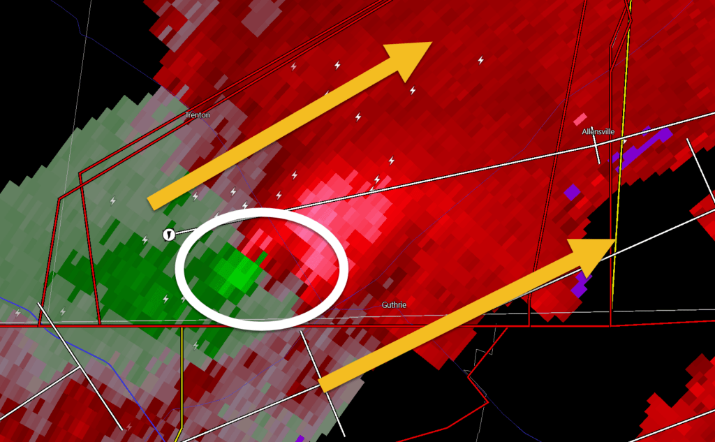
A TORNADO WARNING REMAINS IN EFFECT UNTIL 215 PM CST FOR SOUTHERN
CHRISTIAN AND SOUTHERN TODD COUNTIES…
At 150 PM CST, a confirmed large and extremely dangerous tornado was
located near Clarksville, moving northeast at 45 mph.
This tornado will cross Interstate 24 near the Kentucky Tennessee
line by 155 pm.
This is a PARTICULARLY DANGEROUS SITUATION. TAKE COVER NOW!
HAZARD…Damaging tornado.
SOURCE…Weather spotters confirmed tornado.
IMPACT…You are in a life-threatening situation. Flying debris may
be deadly to those caught without shelter. Mobile homes
will be destroyed. Considerable damage to homes,
businesses, and vehicles is likely and complete destruction
is possible.
The tornado will be near…
Guthrie around 155 PM CST.
This includes Interstate 24 in Kentucky between Mile Markers 91 and
92.
1:44 PM
Tornado Warning
National Weather Service Paducah KY
144 PM CST Sat Dec 9 2023
The National Weather Service in Paducah has issued a
- Tornado Warning for…
Southeastern Christian County in south central Kentucky…
Southern Todd County in south central Kentucky… - Until 215 PM CST.
- At 144 PM CST, a tornado producing storm was located near
Clarksville, moving northeast at 45 mph. HAZARD…Damaging tornado. SOURCE…Radar confirmed tornado. IMPACT…Flying debris will be dangerous to those caught without
shelter. Mobile homes will be damaged or destroyed.
Damage to roofs, windows, and vehicles will occur. Tree
damage is likely. - This tornadic storm will be near…
Oak Grove and Guthrie around 150 PM CST.
This includes Interstate 24 in Kentucky between Mile Markers 89 and
92.
PRECAUTIONARY/PREPAREDNESS ACTIONS…
To repeat, a tornado is on the ground. TAKE COVER NOW! Move to a
basement or an interior room on the lowest floor of a sturdy
building. Avoid windows. If you are outdoors, in a mobile home, or in
a vehicle, move to the closest substantial shelter and protect
yourself from flying debris.
1:42 PM
Christian, and Todd Counties
Stay weather aware. There is rotation south of Fort Campbell. The rotation is moving east northeast at 60 mph. A tornado is possible with this storm.
Be prepared to seek shelter.
LIVE RADAR
https://weatherobservatory.com/radar_hoptown.htm
https://weatherobservatory.com/radar_paducah.htm
And a Facebook thread
https://wtalk.co/WFRX5MN9
1:36 PM
Christian, and Todd Counties
Stay weather aware. Intense storms are approaching or moving through the area.
Be prepared to seek shelter.
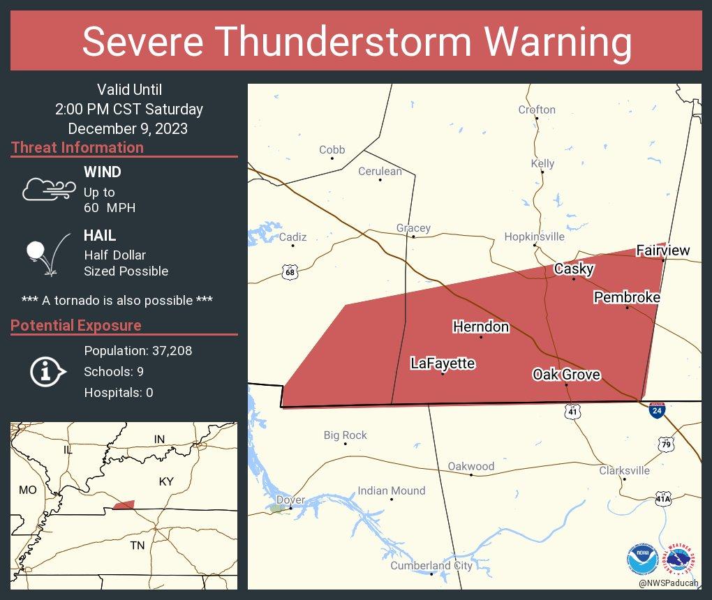
Severe Thunderstorm Warning
National Weather Service Paducah KY
136 PM CST Sat Dec 9 2023
The National Weather Service in Paducah has issued a
- Severe Thunderstorm Warning for…
Southeastern Christian County in south central Kentucky…
Todd County in south central Kentucky… - Until 215 PM CST.
- At 136 PM CST, severe thunderstorms were located along a line
extending from 6 miles south of Hopkinsville to 8 miles southwest
of Fort Campbell, moving northeast at 50 mph. HAZARD…60 mph wind gusts and quarter size hail. SOURCE…Radar indicated. IMPACT…Hail damage to vehicles is expected. Expect wind damage
to roofs, siding, and trees. - Locations impacted include…
Oak Grove, Elkton, Guthrie, Pembroke, Trenton, Justice,
Allensville, and Everett.
This includes Interstate 24 in Kentucky between Mile Markers 88 and
92.
PRECAUTIONARY/PREPAREDNESS ACTIONS…
A Tornado Watch remains in effect until 700 PM CST for south central
Kentucky.
1:34 PM
I am watching a very strong storm on the KY/TN border. This will impacts Christian and Todd Counties. I can’t rule out a tornado. Stay alert.
Movement is east northeast at 60 mph.
1:20 PM
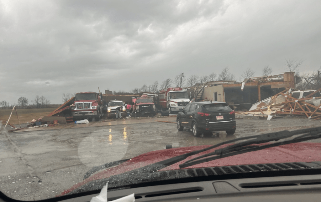
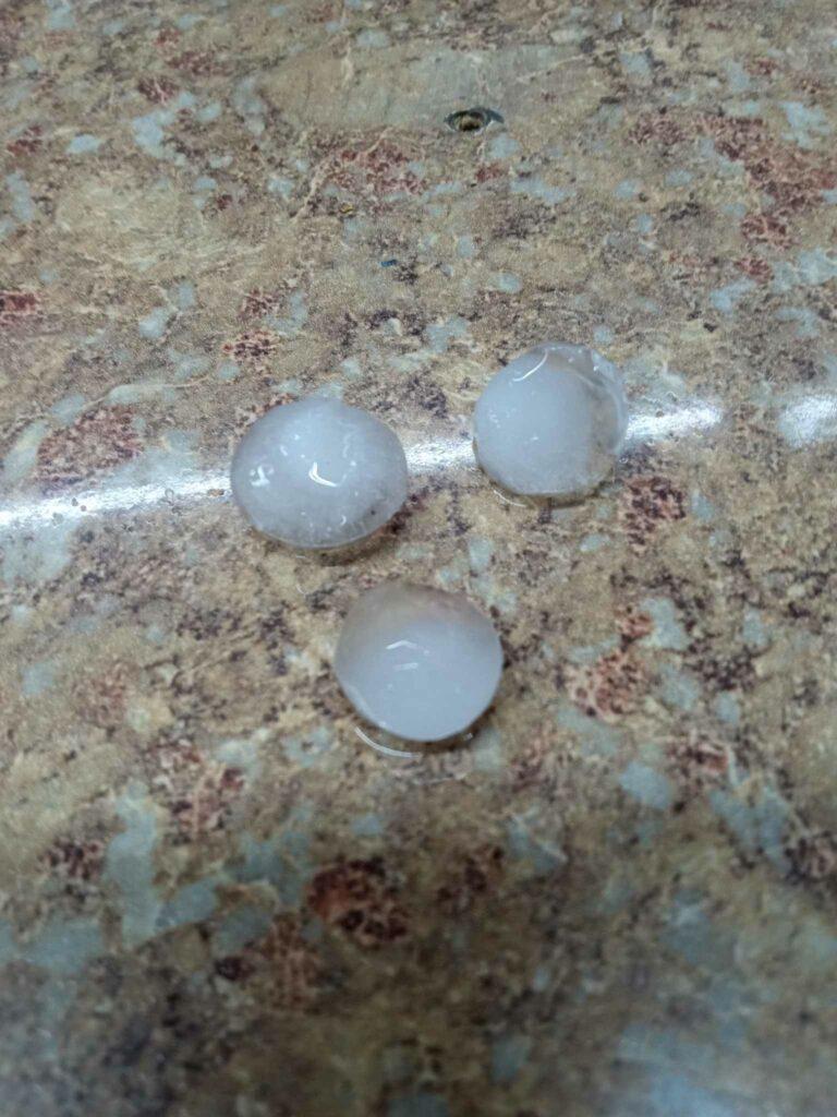
Some additional damage photos from Rutherford, Tennessee. Taken by Ethan Goad @Ethangoad23
1:19 PM
Trigg, Christian, and Todd Counties
Stay weather aware. Intense storms are approaching or moving through the area.
I am watching some rotation east northeast of Dover, Tennessee. Moving northeast at 60 mph.
Be prepared to seek shelter.
LIVE RADAR
https://weatherobservatory.com/radar_hoptown.htm
https://weatherobservatory.com/radar_paducah.htm
And a Facebook thread
https://wtalk.co/WFRX5MN9
1:10 PM
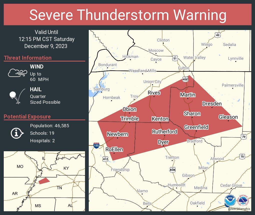
BULLETIN – IMMEDIATE BROADCAST REQUESTED
Severe Thunderstorm Warning
National Weather Service Paducah KY
113 PM CST Sat Dec 9 2023
LIVE RADAR
https://weatherobservatory.com/radar_hoptown.htm
https://weatherobservatory.com/radar_paducah.htm
And a Facebook thread
https://wtalk.co/WFRX5MN9
The National Weather Service in Paducah has issued a
- Severe Thunderstorm Warning for…
Southern Christian County in south central Kentucky…
Southeastern Trigg County in western Kentucky… - Until 200 PM CST.
- At 113 PM CST, severe thunderstorms were located along a line
extending from 6 miles northwest of Big Rock to 6 miles southwest
of Dover, moving east at 35 mph. HAZARD…60 mph wind gusts and half dollar size hail. SOURCE…Radar indicated. IMPACT…Hail damage to vehicles is expected. Expect wind damage
to roofs, siding, and trees. - Locations impacted include…
Hopkinsville, Oak Grove, Fort Campbell, Clarksville, Pembroke,
Lafayette, and Herndon.
This includes the following highways…
Interstate 24 in Kentucky between Mile Markers 74 and 92.
Pennyrile Parkway between Mile Markers 1 and 7.
PRECAUTIONARY/PREPAREDNESS ACTIONS…
A Tornado Watch remains in effect until 700 PM CST for south central
and western Kentucky.
For your protection move to an interior room on the lowest floor of a
building.
1:08 PM
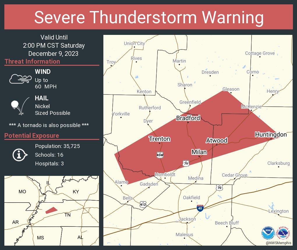
Severe Thunderstorm Warning
National Weather Service Memphis TN
110 PM CST Sat Dec 9 2023
The National Weather Service in Memphis has issued a
- Severe Thunderstorm Warning for…
Central Crockett County in west Tennessee…
Southeastern Weakley County in west Tennessee…
Central Gibson County in west Tennessee…
Northwestern Carroll County in west Tennessee… - Until 200 PM CST.
- At 109 PM CST, a severe thunderstorm was located 7 miles northwest
of Humboldt, moving east at 45 mph. HAZARD…60 mph wind gusts and nickel size hail. SOURCE…Radar indicated. IMPACT…Expect damage to roofs, siding, and trees. - Locations impacted include…
Humboldt, Milan, McKenzie, Trenton, Huntingdon, Gleason, Bradford,
Atwood, Trezevant, Gibson, McLemoresville, Tuckers Corner, Quincy,
Gibson Wells, Cades, New Enterprise, Ledbetter, Staffords Store,
Brazil, and Vaughns Grove.
PRECAUTIONARY/PREPAREDNESS ACTIONS…
Remain alert for a possible tornado! Tornadoes can develop quickly
from severe thunderstorms. If you spot a tornado go at once into the
storm shelter or small central room in a sturdy structure.
For your protection move to an interior room on the lowest floor of a
building.
1:05 PM
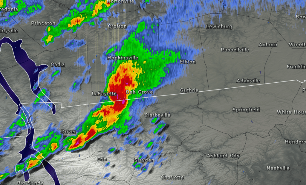
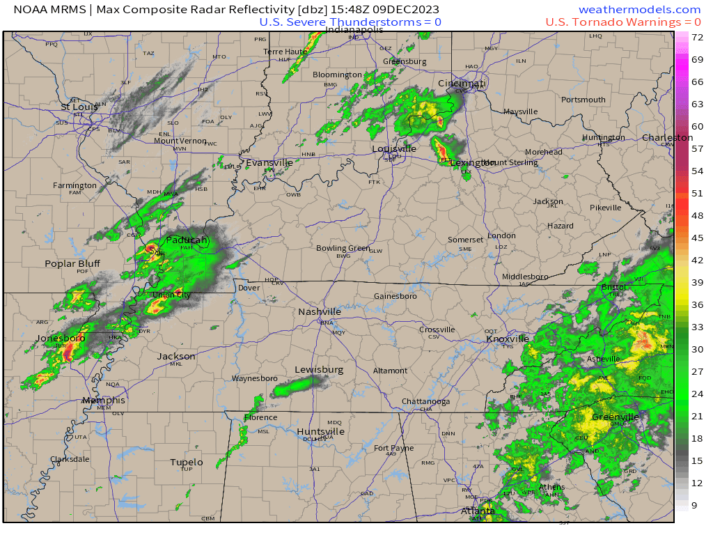
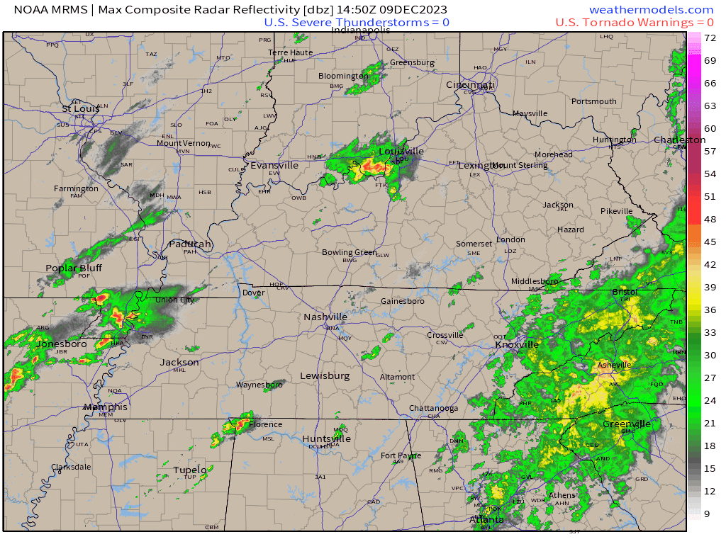
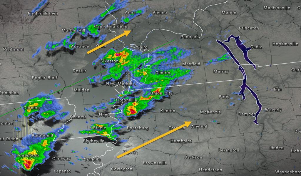
Radar shows showers and thunderstorms moving east northeast.
If you haven’t subscribed to www.weathertalk.com then take a minute and do that. Then, download the Beau Dodson Weather app. I will be sending out messages today.
Apple users: Beau Dodson Weather App
https://wtalk.co/9EZYG8A8
Android users: Beau Dodson Weather App
https://wtalk.co/ZEWYU8ME
Beau Dodson Radars and Lightning Data
Interactive local city-view radars. Clickable watches and warnings.
https://wtalk.co/B3XHASFZ
Backup radar site in case the above one is not working.
https://weathertalk.com/morani
Regional Radar
https://imagery.weathertalk.com/prx/RadarLoop.mp4
*NEW* Zoom interactive radar (with storm chaser streams)
https://wtalk.co/AVWG7GM7
Real time lightning tracker system two. https://map.blitzortung.org/#5.02/37.95/-86.99
Lightning Data (zoom in and out of your local area)
https://wtalk.co/WJ3SN5UZ
1:00 PM
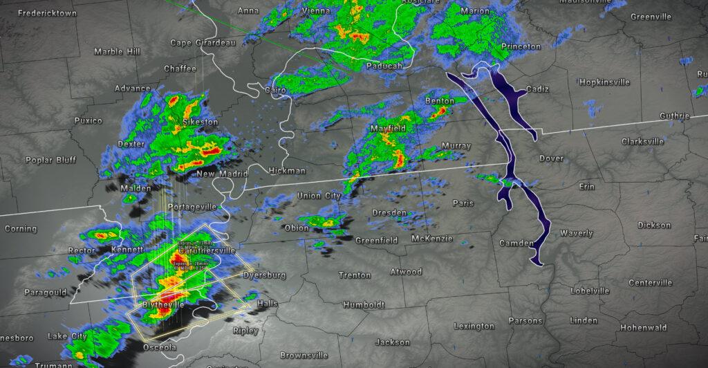
Tornado strikes northwest Tennessee.
Additional details.
12:53 PM
Calloway, Trigg, and Christian
Henry County
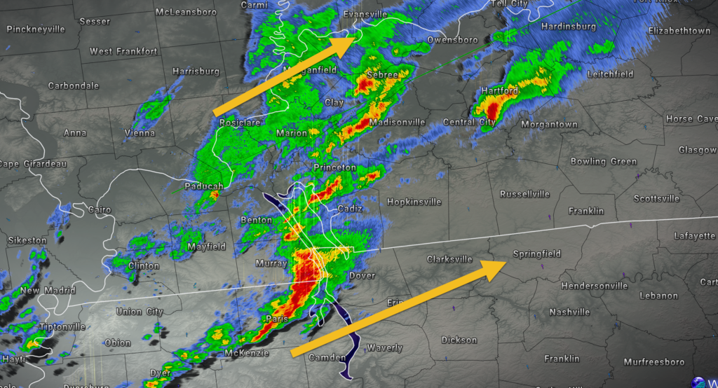
A line of severe thunderstorms is moving east northeast at 60 mph. The line was pushing through far southeastern Calloway County and eastern Henry County.
This line will need to be monitored as it continues to move into south-central Kentucky.
The primary concern will be 60 mph wind gusts and quarter size hail. The storm did produce tornadoes earlier, as well.
Stay weather aware until the storms exit.
LIVE RADAR
https://weatherobservatory.com/radar_paducah.htm
And a Facebook thread
https://wtalk.co/WFRX5MN9
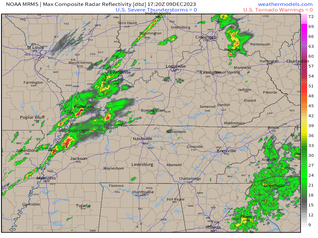
2:44 PM
Strong storms continue to push east northeast at 60 mph. Additional warnings are possible over the coming hours.
If you haven’t subscribed to www.weathertalk.com then take a minute and do that. Then, download the Beau Dodson Weather app. I will be sending out messages today.
Apple users: Beau Dodson Weather App
https://wtalk.co/9EZYG8A8
Android users: Beau Dodson Weather App
https://wtalk.co/ZEWYU8ME
Beau Dodson Radars and Lightning Data
Interactive local city-view radars. Clickable watches and warnings.
https://wtalk.co/B3XHASFZ
Backup radar site in case the above one is not working.
https://weathertalk.com/morani
Regional Radar
https://imagery.weathertalk.com/prx/RadarLoop.mp4
*NEW* Zoom interactive radar (with storm chaser streams)
https://wtalk.co/AVWG7GM7
Real time lightning tracker system two. https://map.blitzortung.org/#5.02/37.95/-86.99
Lightning Data (zoom in and out of your local area)
https://wtalk.co/WJ3SN5UZ
12:37 PM
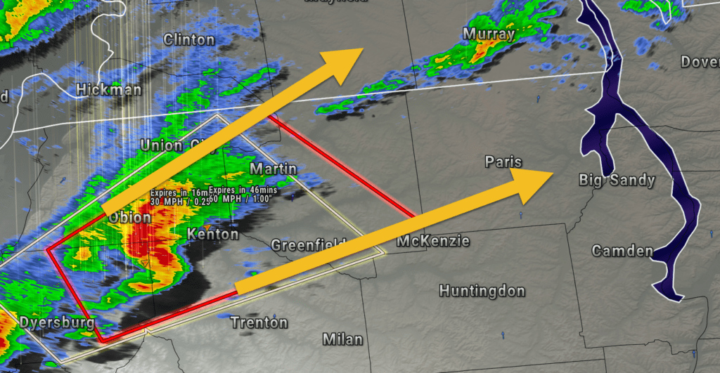
Weakley TN-Henry TN-
1236 PM CST Sat Dec 9 202
THE TORNADO WARNING FOR NORTHEASTERN WEAKLEY AND HENRY COUNTIES IS
CANCELLED…
The storm which prompted the warning has weakened below severe
limits, and no longer appears capable of producing a tornado.
Therefore, the warning has been cancelled.
A Tornado Watch remains in effect until 700 PM CST for west
Tennessee.
Remember, a Severe Thunderstorm Warning still remains in effect for
Henry and Weakley Counties.
12:33 PM
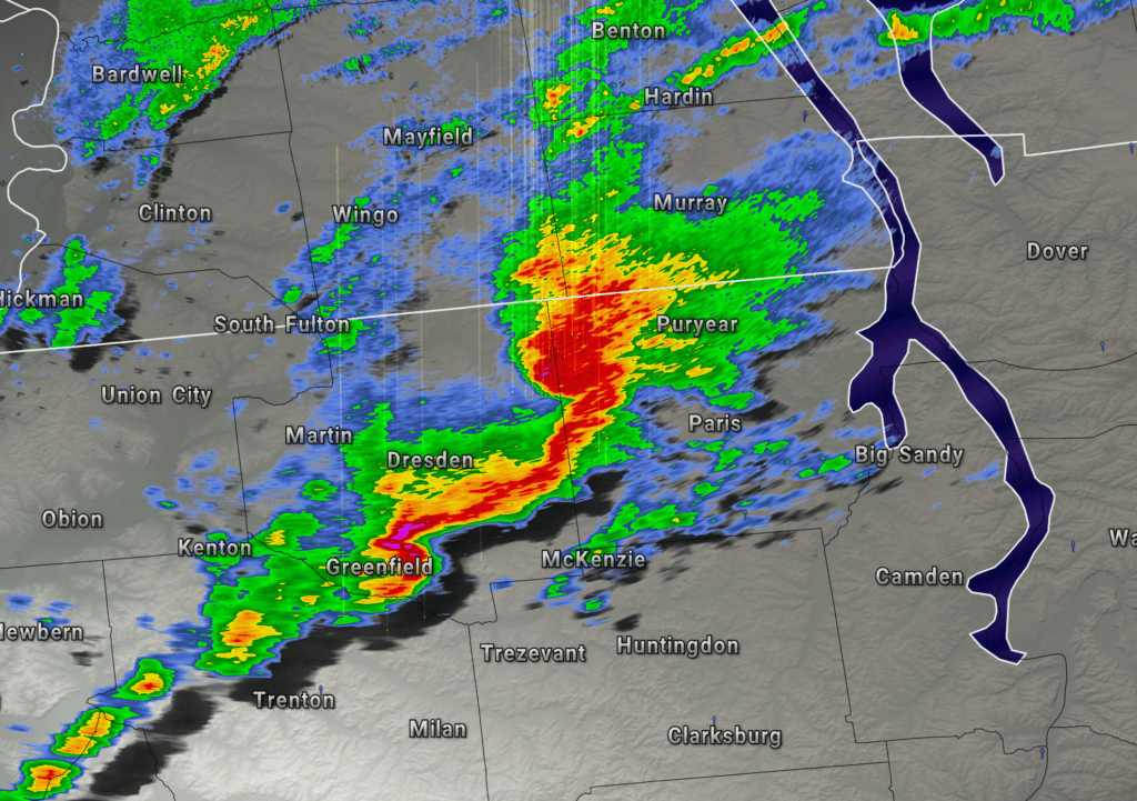
Calloway, and Henry Counties
There are two areas of rotation on radar. One near Puryear and one north of Paris, Tennessee.
The storm continues to move northeast.
The NWS also issued a severe thunderstorm warning for southeastern Calloway County for this storm.
The tornado, if it is still on the ground, is in Henry County, TN.
Seek shelter immediately if you are in the path of the tornado.
LIVE RADAR
https://weatherobservatory.com/radar_paducah.htm
And a Facebook thread
https://wtalk.co/WFRX5MN9
12:22 PM
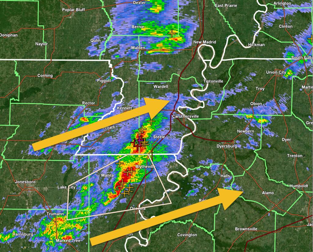
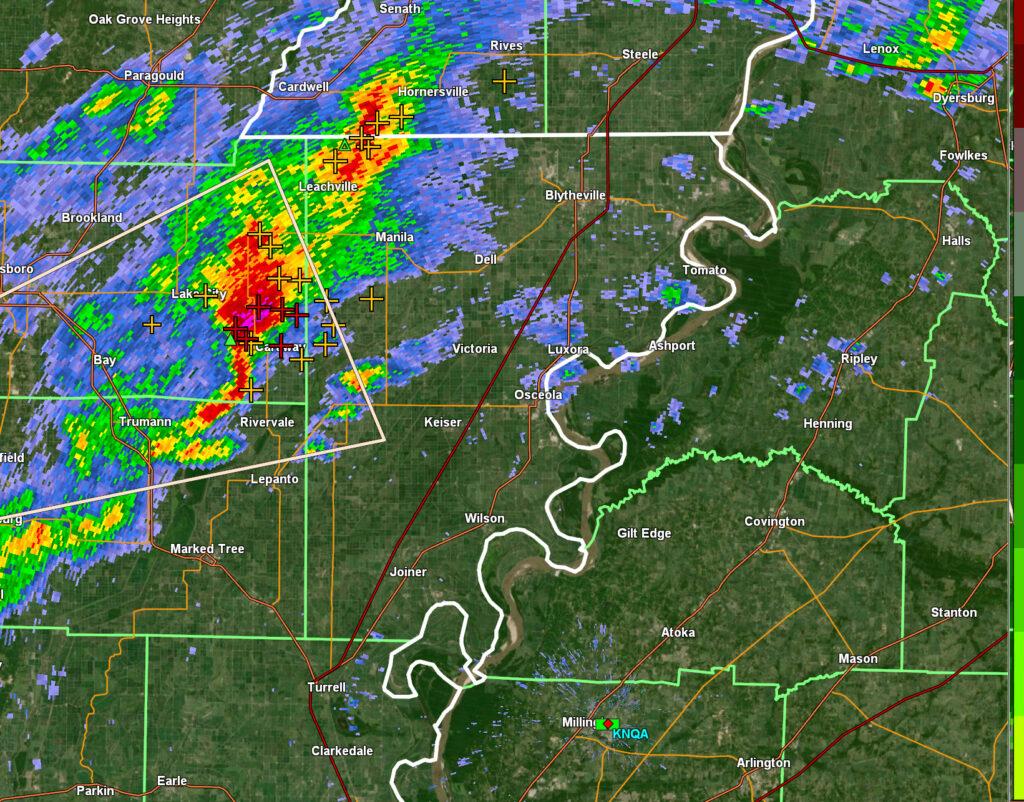
The Rutherford, Tennessee fire house has been struck by a tornado.
12:19 PM
Tornado Warning
National Weather Service Memphis TN
1222 PM CST Sat Dec 9 2023
The National Weather Service in Memphis has issued a
- Tornado Warning for…
Northeastern Weakley County in west Tennessee…
Henry County in west Tennessee… - Until 100 PM CST.
- At 1221 PM CST, a severe thunderstorm capable of producing a
tornado was located over Cottage Grove, or 8 miles northwest of
Paris, moving northeast at 45 mph. HAZARD…Tornado. SOURCE…Radar indicated rotation. IMPACT…Flying debris will be dangerous to those caught without
shelter. Mobile homes will be damaged or destroyed.
Damage to roofs, windows, and vehicles will occur. Tree
damage is likely. - Locations impacted include…
Paris, Paris Landing State Park, Cottage Grove, Palmersville,
Routon, Puryear, Jones Mill, Foundry Hill, Crossland, Buchanan,
India, Mill Creek, Osage, Sunnyside, Whitlock, Porter Court,
Conyersville, Pine Hill, and Big Sandy Unit Tennessee National
Wildlife Refuge.
PRECAUTIONARY/PREPAREDNESS ACTIONS…
TAKE COVER NOW! Move to a storm shelter or an interior room on the
lowest floor of a sturdy building. Avoid windows. If you are
outdoors, in a mobile home, or in a vehicle, move to the closest
substantial shelter and protect yourself from flying debris.
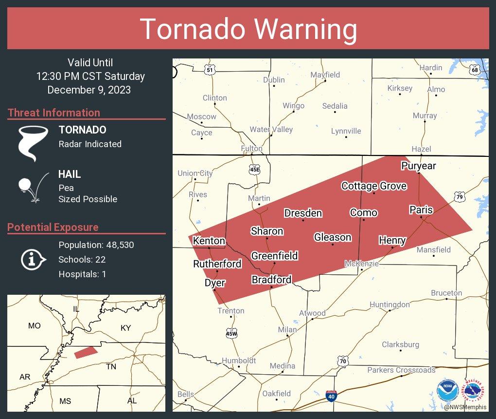
12:18 PM
A TORNADO WARNING REMAINS IN EFFECT UNTIL 1230 PM CST FOR CENTRAL
WEAKLEY AND WESTERN HENRY COUNTIES…
At 1218 PM CST, a severe thunderstorm capable of producing a tornado
was located near Cottage Grove, or 7 miles northwest of Paris, moving
northeast at 50 mph.
HAZARD…Tornado and quarter size hail.
SOURCE…Radar indicated rotation.
IMPACT…Flying debris will be dangerous to those caught without
shelter. Mobile homes will be damaged or destroyed. Damage
to roofs, windows, and vehicles will occur. Tree damage is
likely.
Locations impacted include…
Martin, Paris, McKenzie, Dresden, Greenfield, Gleason, Sharon,
Cottage Grove, Routon, Palmersville, Puryear, Henry, Sandhill, Jones
Mill, Crossland, Como, Ralston, Sunnyside, Pisgah, and Whitlock.
PRECAUTIONARY/PREPAREDNESS ACTIONS
12:12 PM
Weakley, Calloway, and Henry Counties
The tornado is about to enter Henry County, TN. Near Eagle Hill and Como, TN. “
Seek shelter immediately if you are in the path of the tornado.
LIVE RADAR
https://weatherobservatory.com/radar_paducah.htm
And a Facebook thread
https://wtalk.co/WFRX5MN9
A tornado is on the ground. Seek shelter immediately if you are in the path of this tornado.
Remain sheltered.
Calloway County – monitor updates. The storm could impact the south part of the county.
12:09 PM
Circulation about to enter Henry County.
12:07 PM
Tornadic circulation just passed Dresden heading towards Ore Springs.
12:05 PM
Weakley, Calloway, and Henry Counties
LIVE RADAR
https://weatherobservatory.com/radar_paducah.htm
And a Facebook thread
https://wtalk.co/WFRX5MN9
Radar shows strong rotation and debris south of Dresden, Tennessee. Movement is northeast at 60 mph.
A tornado is on the ground. Seek shelter immediately if you are in the path of this tornado.
Remain sheltered.
Calloway County – monitor updates. The storm could impact the south part of the county.
12:01 PM
LIVE RADAR
https://weatherobservatory.com/radar_paducah.htm
I also have a thread with updates here
https://wtalk.co/S
And a Facebook thread
https://wtalk.co/WFRX5MN9
A tornado may be on the ground near West Union and Sandhill, Tennessee. In Weakley County. Moving northeast at 60 mph. Earlier, radar showed debris being lofted in the air with this tornado.
The debris signature is not as strong right now, but that does not mean the tornado has lifted.
Remain sheltered.
Calloway County – monitor updates. The storm could impact the south part of the county.
11:55 AM
The tornado is on the ground near Sharon, Tennessee doing damage.
11:48 AM
At 1148 AM CST, a confirmed large and extremely dangerous tornado was located over Sharon, or 8 miles south of Martin, moving northeast at 50 mph.
This is a PARTICULARLY DANGEROUS SITUATION. TAKE COVER NOW!
Severe Weather Statement
National Weather Service Memphis TN
1148 AM CST Sat Dec 9 2023
TNC053-079-131-183-091830-
/O.CON.KMEG.TO.W.0076.000000T0000Z-231209T1830Z/
Weakley TN-Gibson TN-Obion TN-Henry TN-
1148 AM CST Sat Dec 9 2023
…A TORNADO WARNING REMAINS IN EFFECT UNTIL 1230 PM CST FOR
WEAKLEY…NORTHEASTERN GIBSON…SOUTHEASTERN OBION AND WESTERN HENRY
COUNTIES…
At 1148 AM CST, a confirmed large and extremely dangerous tornado was
located over Sharon, or 8 miles south of Martin, moving northeast at
50 mph.
This is a PARTICULARLY DANGEROUS SITUATION. TAKE COVER NOW!
HAZARD…Damaging tornado.
SOURCE…Radar confirmed tornado.
IMPACT…You are in a life-threatening situation. Flying debris may
be deadly to those caught without shelter. Mobile homes
will be destroyed. Considerable damage to homes,
businesses, and vehicles is likely and complete destruction
is possible.
Locations impacted include…
Martin, Paris, McKenzie, Dresden, Dyer, Greenfield, Gleason, Kenton,
Rutherford, Bradford, Sharon, Cottage Grove, Routon, Palmersville,
Puryear, Henry, Sandhill, Jones Mill, Good Luck, and Crossland.
PRECAUTIONARY/PREPAREDNESS ACTIONS…
To repeat, a large, extremely dangerous and potentially deadly
tornado is on the ground. To protect your life, TAKE COVER NOW! Move
to a storm shelter or an interior room on the lowest floor of a
sturdy building. Avoid windows. If you are outdoors, in a mobile
home, or in a vehicle, move to the closest substantial shelter and
protect yourself from flying debris.
11:38 AM
BULLETIN – EAS ACTIVATION REQUESTED
Tornado Warning
National Weather Service Memphis TN
1144 AM CST Sat Dec 9 2023
The National Weather Service in Memphis has issued a
- Tornado Warning for…
Weakley County in west Tennessee…
Northeastern Gibson County in west Tennessee…
Southeastern Obion County in west Tennessee…
Western Henry County in west Tennessee… - Until 1230 PM CST.
- At 1144 AM CST, a severe thunderstorm capable of producing a
tornado was located near Sharon, or 10 miles south of Martin,
moving northeast at 50 mph. HAZARD…Tornado. SOURCE…Radar indicated rotation. IMPACT…Flying debris will be dangerous to those caught without
shelter. Mobile homes will be damaged or destroyed.
Damage to roofs, windows, and vehicles will occur. Tree
damage is likely. - Locations impacted include…
Martin, Paris, McKenzie, Dresden, Dyer, Greenfield, Gleason,
Kenton, Rutherford, Bradford, Sharon, Cottage Grove, Routon,
Palmersville, Puryear, Henry, Sandhill, Jones Mill, Good Luck, and
Crossland.
PRECAUTIONARY/PREPAREDNESS ACTIONS…
TAKE COVER NOW! Move to a storm shelter or an interior room on the
lowest floor of a sturdy building. Avoid windows. If you are
outdoors, in a mobile home, or in a vehicle, move to the closest
substantial shelter and protect yourself from flying debris.
11:37 AM
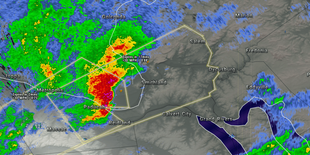
Severe Weather Statement
Massac, Pope, and Livingston Counties
Radar
https://weatherobservatory.com/radar_paducah.htm
A line of storms is moving through southern Massac County. It is about to enter Pope and Livingston Counties.
The storm could produce pockets of wind damage and nickel size hail. The hail could be heavy in isolated spots.
Stay weather aware.
11:35 AM
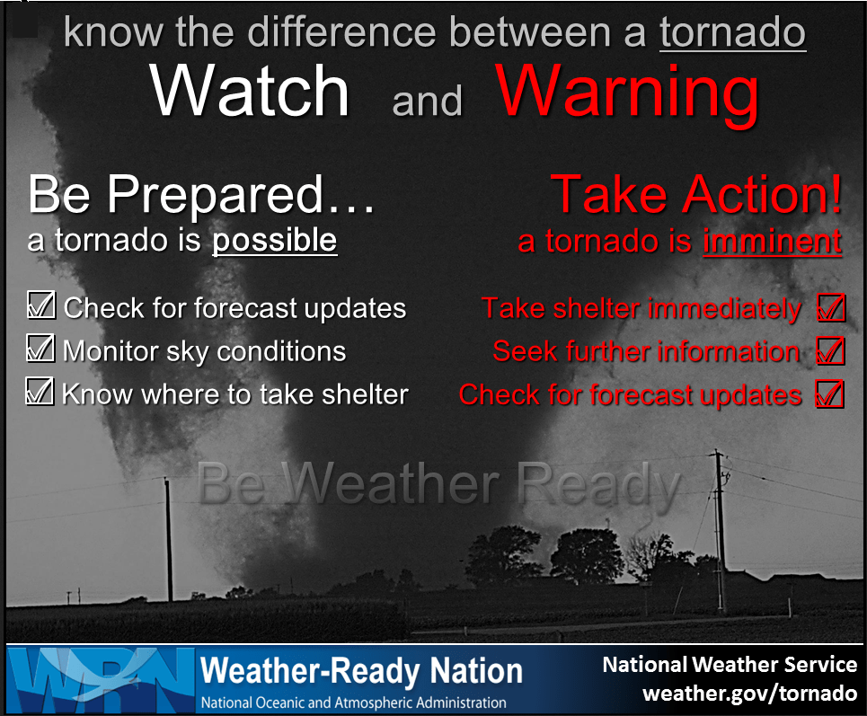
A tornado watch has been issued. A watch means conditions are favorable for tornadoes and to stay alert.
A WARNING means to seek shelter.
If you haven’t subscribed to www.weathertalk.com then take a minute and do that. Then, download the Beau Dodson Weather app. I will be sending out messages today.
11:26 AM
BULLETIN – IMMEDIATE BROADCAST REQUESTED
LIVE RADAR
https://weatherobservatory.com/radar_dyers.htm
And a Facebook thread
https://wtalk.co/WFRX5MN9
Severe Thunderstorm Warning
National Weather Service Memphis TN
1124 AM CST Sat Dec 9 2023
The National Weather Service in Memphis has issued a
Severe Thunderstorm Warning for…
Central Weakley County in west Tennessee…
Northeastern Dyer County in west Tennessee…
Northern Gibson County in west Tennessee…
Southeastern Obion County in west Tennessee…
Until 1215 PM CST.
At 1123 AM CST, a severe thunderstorm was located over Newbern, or 9 miles northeast of Dyersburg, moving northeast at 45 mph.
HAZARD…60 mph wind gusts and quarter size hail.
SOURCE…Radar indicated.
IMPACT…Hail damage to vehicles is expected. Expect wind damage to roofs, siding, and trees.
Locations impacted include…
Martin, Newbern, Dresden, Dyer, Greenfield, Gleason, Kenton,
Rutherford, Obion, Sharon, Cloverdale, Trimble, Rives, Yorkville,
Sandhill, Mason Hall, Mount Pelia, Glass, Good Luck, and Lapata.
PRECAUTIONARY/PREPAREDNESS ACTIONS…
For your protection move to an interior room on the lowest floor of a
building.
11:16 AM
Obion, Weakley, and Henry Counties
11:15 AM Sat Dec 9 2023
LIVE RADAR
https://weatherobservatory.com/radar_dyers.htm
And a Facebook thread
https://wtalk.co/WFRX5MN9
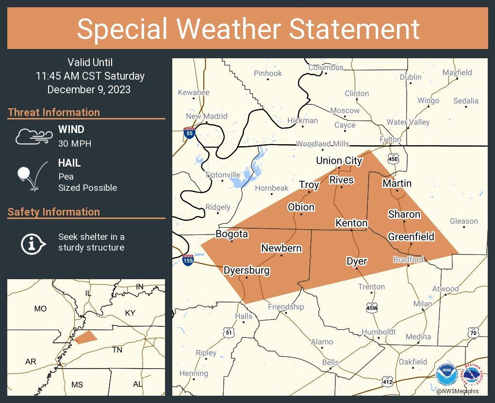
A STRONG THUNDERSTORM WILL IMPACT SOUTHWESTERN WEAKLEY, EASTERN DYER, NORTHERN GIBSON AND SOUTHEASTERN OBION COUNTIES THROUGH 1145 AM CST.
At 1112 AM CST, Doppler radar was tracking a strong thunderstorm over Newbern, or near Dyersburg, moving northeast at 50 mph.
HAZARD…Winds in excess of 30 mph and pea size hail.
SOURCE…Radar indicated.
IMPACT…Gusty winds could knock down tree limbs and blow around unsecured objects. Minor hail damage to vegetation is possible.
Locations impacted include
Dyersburg, Martin, Union City, Newbern, Dyer, Greenfield, Troy, Kenton, Rutherford, Obion, Bradford, Sharon, Cloverdale, Bradleytown, Miston, Trimble, Rives, Yorkville, Cat Corner, and Fowlkes.
PRECAUTIONARY/PREPAREDNESS ACTIONS…
If outdoors, consider seeking shelter inside a building.
11:03 AM
Ballard and Carlisle Counties
McCracken and Graves Counties.
A line of intense storms is approaching from the west. This line of storms has a history of producing strong winds and pockets of heavy hail.
The storm is moving east northeast at 40 mph.
Stay weather aware.
LIVE RADAR
https://weatherobservatory.com/radar_paducah.htm
And a Facebook thread
https://wtalk.co/WFRX5MN9
If you haven’t subscribed to www.weathertalk.com then take a minute and do that. Then, download the Beau Dodson Weather app. I will be sending out messages today.
Beau Dodson Radars and Lightning Data
Interactive local city-view radars. Clickable watches and warnings.
https://wtalk.co/B3XHASFZ
Backup radar site in case the above one is not working.
https://weathertalk.com/morani
Regional Radar
https://imagery.weathertalk.com/prx/RadarLoop.mp4
*NEW* Zoom interactive radar (with storm chaser streams)
https://wtalk.co/AVWG7GM7
Real time lightning tracker system two. https://map.blitzortung.org/#5.02/37.95/-86.99
Lightning Data (zoom in and out of your local area)
https://wtalk.co/WJ3SN5UZ
10:55 AM
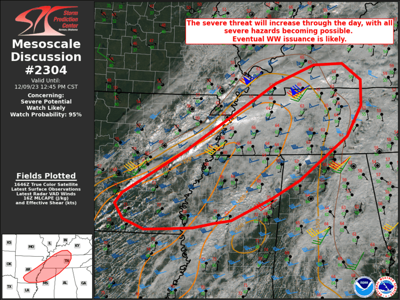
A severe thunderstorm or tornado watch is going to be issued for portions of the region. Just waiting on SPC to issue it.
SPC COMMENTS CLICK HERE
Mesoscale Discussion
2304 NWS Storm Prediction Center Norman OK
1050 AM CST Sat Dec 09 2023
Areas affected
Southern/eastern AR
Western KY
Western/middle TN
Northern MS
Northwest AL
Concerning
Severe potential
Watch likely
Probability of Watch Issuance…95 percent
SUMMARY
The severe threat will increase with time, with all severe hazards becoming possible by this afternoon. Eventual watch issuance is likely.
DISCUSSION
A cluster of storms from northeast AR into southwest KY has intensified somewhat over the last 1-2 hours. This convection is likely somewhat elevated, given its relatively fast motion to the northeast and the currently stable appearance boundary-layer clouds on visible satellite across the warm sector to the immediate south. However, MUCAPE of 500-1000 J/kg, relatively cold temperatures aloft, and favorable deep-layer shear could support an isolated short-term hail threat with the strongest elevated storms.
Gradual diurnal heating of an increasingly moist warm sector will continue to remove remaining MLCINH through the morning, with an increase in surface-based storm development expected by midday to early afternoon.
MLCAPE of 1000-2000 J/kg (greater with southwest extent) and effective shear of 50-60 kt will support organized convection. The environment will support the development and sustenance of supercells, though deep-layer flow largely parallel to the approaching cold front may result in a complex storm mode, with both linear and embedded cellular elements.
There will be a tendency for stronger low-level flow to gradually weaken from the southwest with time, but low-level shear/SRH will remain sufficient to support a tornado threat with any sustained supercells later this afternoon.
Otherwise, large hail will remain a threat, and damaging-wind potential will become an increasing concern as storm coverage increases. Eventual watch issuance is likely by early afternoon, and perhaps sooner if ongoing attempts at initiation over central AR begin to mature late this morning.
Dean/Guyer.. 12/09/2023
10:50 AM
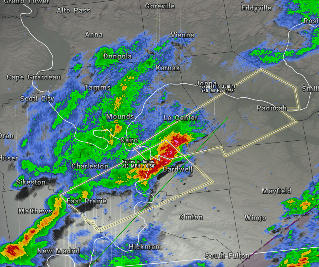
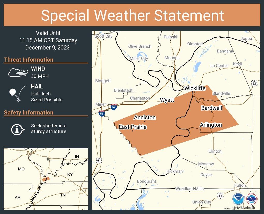
Carlisle KY-Ballard KY-Hickman KY-Mississippi MO-
1046 AM CST Sat Dec 9 2023
Radar
https://weatherobservatory.com/radar_paducah.htm
A strong thunderstorm will impact portions of Carlisle,
northwestern Hickman, south central Ballard and central Mississippi
Counties through 1115 AM CST.
At 1046 AM CST, trained weather spotters reported a strong
thunderstorm over East Prairie, moving northeast at 50 mph.
HAZARD…Half inch hail.
SOURCE…Trained weather spotters.
IMPACT…Minor damage to outdoor objects is possible.
This strong thunderstorm will be near…
Wyatt and Anniston around 1050 AM CST.
Bardwell and Wickliffe around 1100 AM CST.
PRECAUTIONARY/PREPAREDNESS ACTIONS…
If outdoors, consider seeking shelter inside a building.
10:33 AM
These storms coming out of the MO Bootheel and NE AR will need to be closely monitored as they move into TN and KY. They are moving E NE at 40 mph.
10:18 AM
Saturday, December 9, 2023
10:18 AM
Pemiscot, Lake, and Obion Counties.
Stay weather aware. Additional thunderstorms are moving through and into the area. These storms have a history of producing small hail.
The storms are moving into an environment that could increase their intensity to severe limits. The primary concern will be damaging wind and hail. An isolated tornado risk, as well.
The storms are moving east northeast at 35 mph.
LIVE RADAR
https://weatherobservatory.com/radar_dyers.htm
And a Facebook thread
https://wtalk.co/WFRX5MN9
If you haven’t subscribed to www.weathertalk.com then take a minute and do that. Then, download the Beau Dodson Weather app. I will be sending out messages today.
Beau Dodson Radars and Lightning Data
Interactive local city-view radars. Clickable watches and warnings.
https://wtalk.co/B3XHASFZ
Backup radar site in case the above one is not working.
https://weathertalk.com/morani
Regional Radar
https://imagery.weathertalk.com/prx/RadarLoop.mp4
*NEW* Zoom interactive radar (with storm chaser streams)
https://wtalk.co/AVWG7GM7
Real time lightning tracker system two. https://map.blitzortung.org/#5.02/37.95/-86.99
Lightning Data (zoom in and out of your local area)
https://wtalk.co/WJ3SN5UZ
Dew points continue to climb. The yellow zone are dew points in the 60s. That is a lot of fuel for storms.
10:11 AM
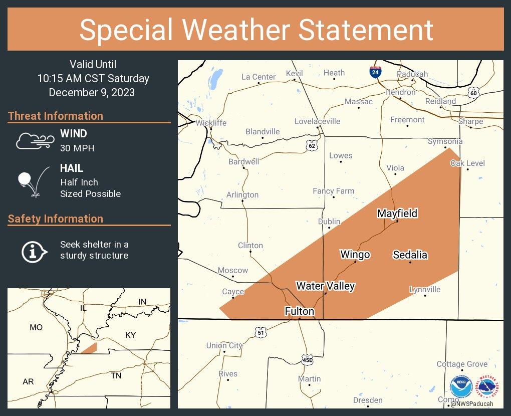
Severe Weather Statement
National Weather Service Paducah KY
1011 AM CST Sat Dec 9 2023
THE SEVERE THUNDERSTORM WARNING FOR SOUTHERN GRAVES COUNTY WILL
EXPIRE AT 1015 AM CST…
The storm which prompted the warning has weakened below severe
limits, and no longer poses an immediate threat to life or property.
Therefore, the warning will be allowed to expire. However small hail
is still possible with this thunderstorm.
10:11 AM radar loop
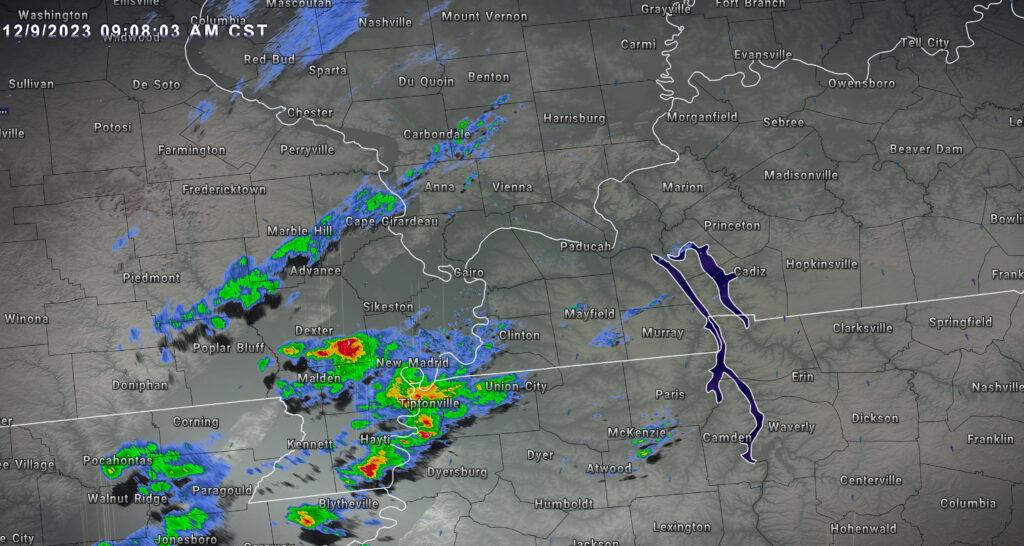
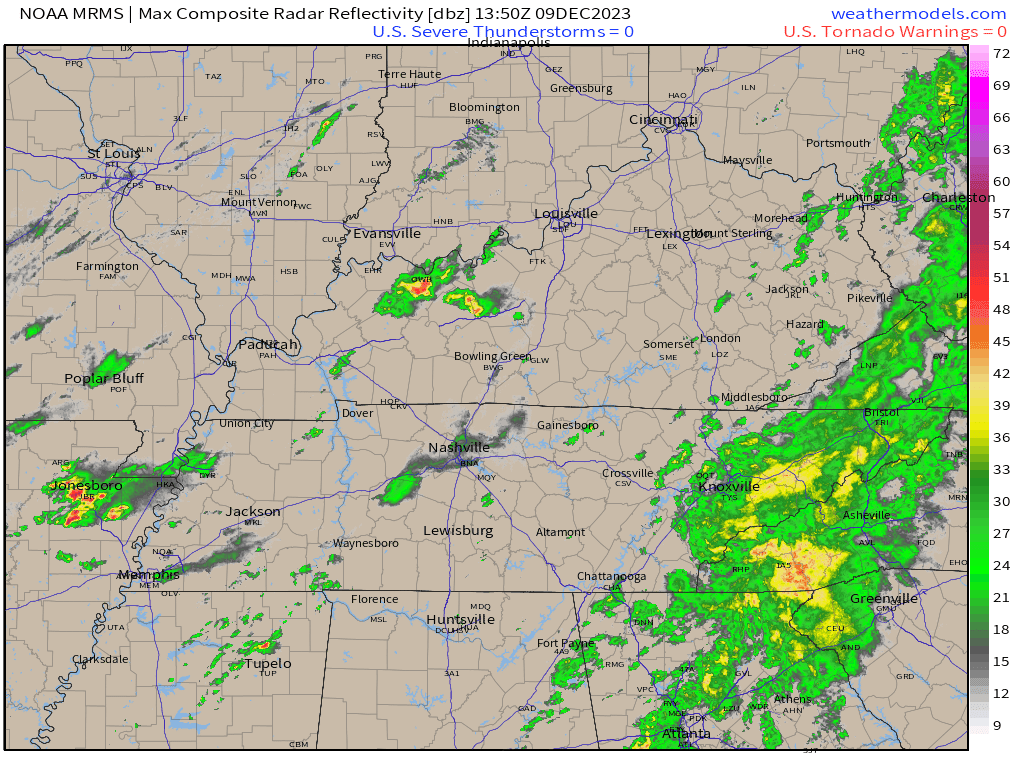
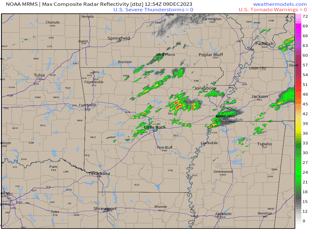
10:00 AM
I have received numerous reports of dime to nickel size hail in Fulton, Kentucky and Fulton, Tennessee. That storm continues to move northeast into Graves County.
Storm in Graves County is weakening just a bit. They may let the warning expire on that one.
9:50 AM
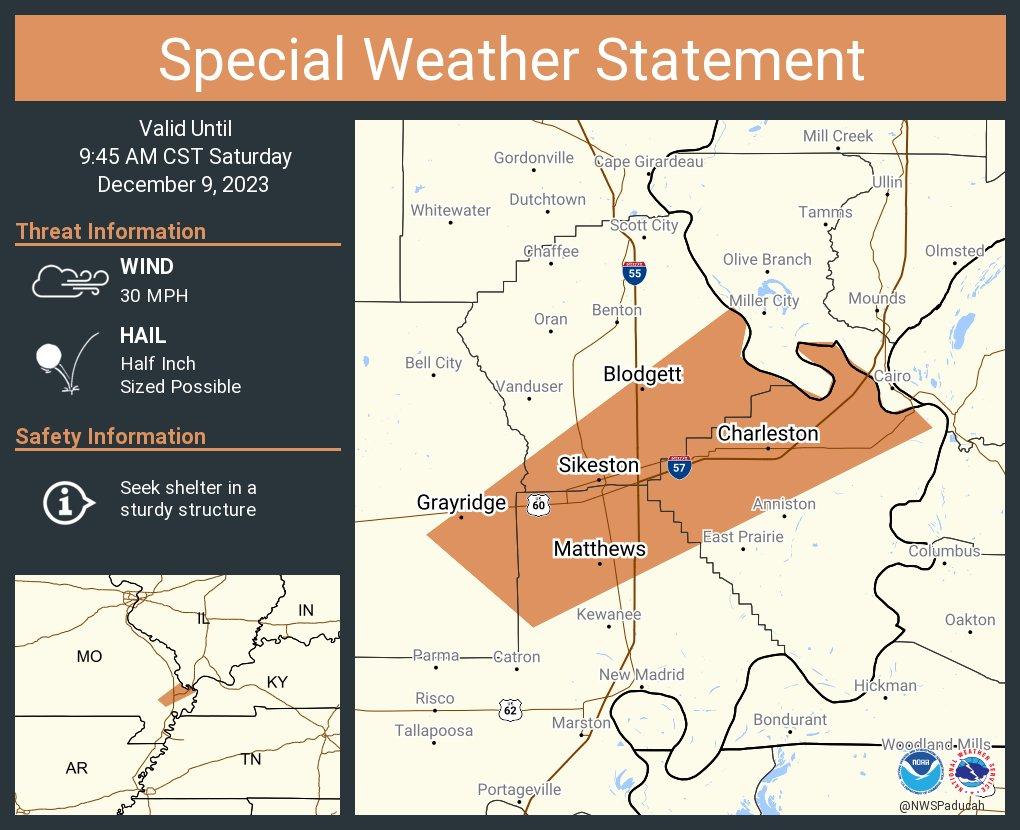
Severe Weather Statement
National Weather Service Paducah KY
959 AM CST Sat Dec 9 2023
THE SEVERE THUNDERSTORM WARNING FOR SOUTHEASTERN HICKMAN COUNTY IS CANCELLED.
The severe thunderstorm which prompted the warning has moved out of
the warned area. Therefore, the warning has been cancelled.
I am also watching this storm in northeast Arkansas as it moves east northeast. It could become severe.
9:48 AM
LIVE RADAR
https://weatherobservatory.com/radar_paducah.htm
And a Facebook thread
https://wtalk.co/WFRX5MN9
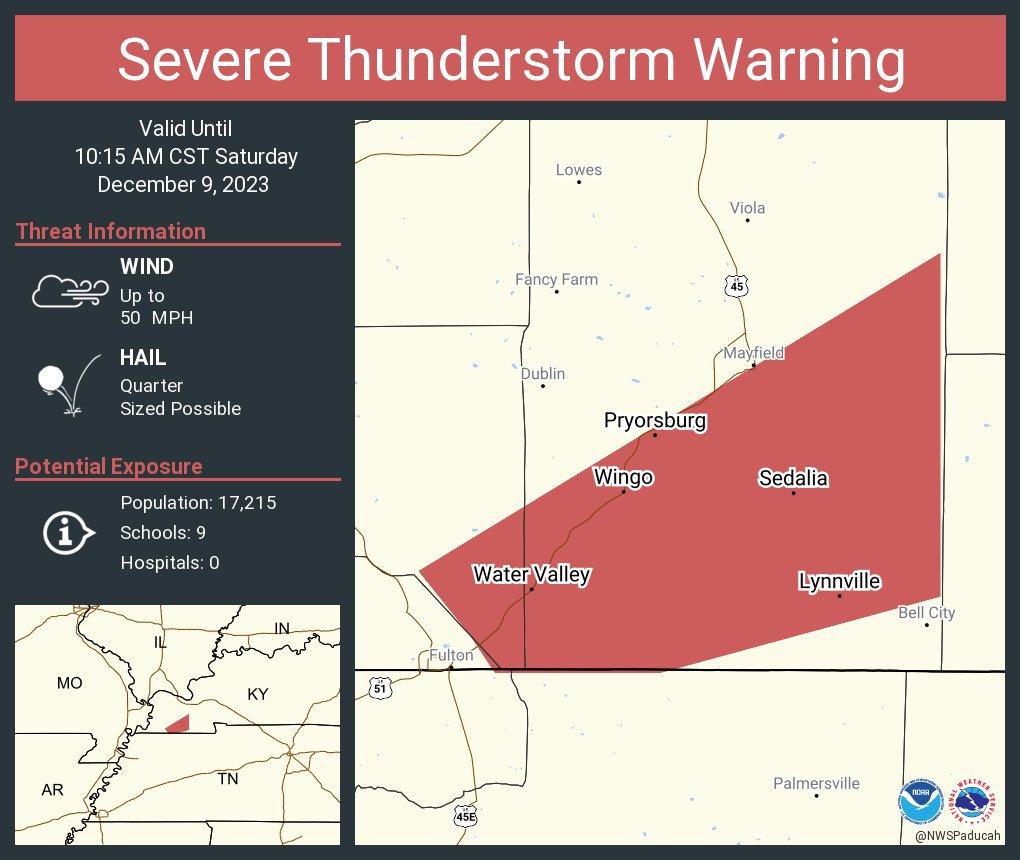

BULLETIN – IMMEDIATE BROADCAST REQUESTED
Severe Thunderstorm Warning
National Weather Service Paducah KY
949 AM CST Sat Dec 9 2023
The National Weather Service in Paducah has issued a
- Severe Thunderstorm Warning for…
Southeastern Hickman County in western Kentucky…
Southern Graves County in western Kentucky… - Until 1015 AM CST.
- At 949 AM CST, a severe thunderstorm was located over Fulton,
moving northeast at 55 mph. HAZARD…Quarter size hail. SOURCE…Radar indicated. IMPACT…Damage to vehicles is expected. - Locations impacted include…
Mayfield, Sedalia, Lynnville, Wingo, Water Valley, and Dukedom.
This includes Interstate 69 in Kentucky between Mile Markers 4 and
16, and between Mile Markers 29 and 33.
PRECAUTIONARY/PREPAREDNESS ACTIONS…
For your protection move to an interior room on the lowest floor of a
building.
&&
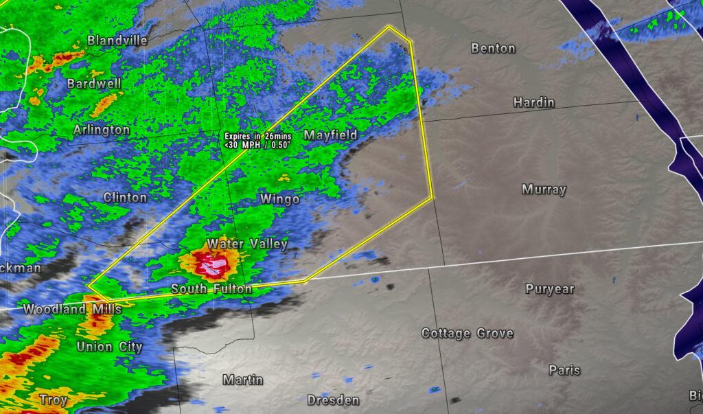
9:47 AM
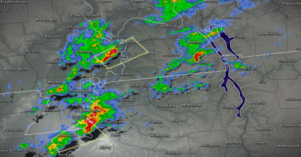
Graves, Fulton, and Hickman Counties
943 AM CST Sat Dec 9 2023
LIVE RADAR
https://weatherobservatory.com/radar_paducah.htm
And a Facebook thread
https://wtalk.co/WFRX5MN9
A strong thunderstorm will impact portions of southeastern Fulton, southeastern Hickman and Graves Counties through 1015 AM CST
At 943 AM CST, Doppler radar was tracking a strong thunderstorm near
South Fulton, or near Fulton, moving northeast at 60 mph.
HAZARD…A quick burst of up to half inch hail.
SOURCE…Radar indicated.
IMPACT…Minor damage to outdoor objects is possible.
This strong thunderstorm will be near
Fulgham around 950 AM CST.
Mayfield and Sedalia around 955 AM CST.
This includes Interstate 69 in Kentucky between Mile Markers 1 and
34.
PRECAUTIONARY/PREPAREDNESS ACTIONS…
If outdoors, consider seeking shelter inside a building.
9:40 AM
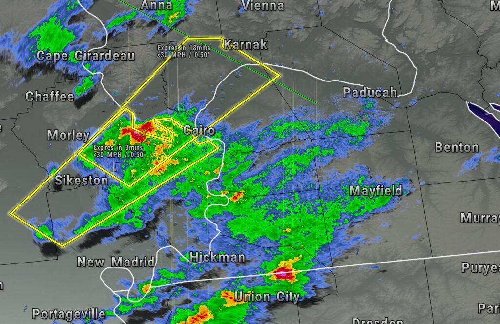
Severe Weather Statement
Alexander, Pulaski, McCracken, Ballard, Scott, and Mississippi Counties
936 AM CST Sat Dec 9 2023
LIVE RADAR
https://weatherobservatory.com/radar_paducah.htm
And a Facebook thread
https://wtalk.co/WFRX5MN9
A strong thunderstorm will impact portions of Pulaski, eastern Alexander, northwestern Ballard, northwestern McCracken, northwestern Mississippi and southeastern Scott Counties through 1000 AM CST
At 935 AM CST, A strong thunderstorm was located near Bertrand, or near Charleston, moving northeast at 55 mph.
HAZARD…Very quick burst of up to half inch hail.
SOURCE…Public. Pea sized hail was reported in Sikeston.
IMPACT…Minor damage to outdoor objects is possible.
This strong thunderstorm will be near
Charleston and Horseshoe Lake Conservation Area around 940 AM CST.
Cairo, Mounds, Mound City, and Olive Branch around 945 AM CST.
Tamms around 955 AM CST.
This includes the following highways…
Interstate 57 in Illinois between Mile Markers 1 and 22.
Interstate 57 in Missouri between Mile Markers 4 and 21.
Interstate 55 between Mile Markers 71 and 76.
PRECAUTIONARY/PREPAREDNESS ACTIONS
If outdoors, consider seeking shelter inside a building.
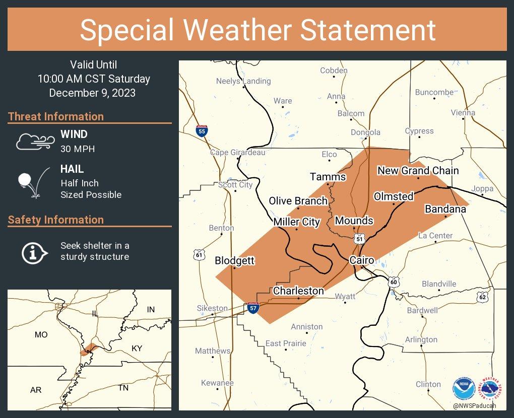
9:34 AM
Showers and thunderstorms are moving northeast through the region. The storms are below severe levels, at this time. Monitor updates.
If you haven’t subscribed to www.weathertalk.com then take a minute and do that. Then, download the Beau Dodson Weather app. I will be sending out messages today.
Beau Dodson Radars and Lightning Data
Interactive local city-view radars. Clickable watches and warnings.
https://wtalk.co/B3XHASFZ
Backup radar site in case the above one is not working.
https://weathertalk.com/morani
Regional Radar
https://imagery.weathertalk.com/prx/RadarLoop.mp4
*NEW* Zoom interactive radar (with storm chaser streams)
https://wtalk.co/AVWG7GM7
Real time lightning tracker system two. https://map.blitzortung.org/#5.02/37.95/-86.99
Lightning Data (zoom in and out of your local area)
https://wtalk.co/WJ3SN5UZ
9:14 AM
Stoddard, New Madrid, Scott, Mississippi Counties
914 AM CST Sat Dec 9 2023
LIVE RADAR
https://weatherobservatory.com/radar_cape.htm
A strong thunderstorm will impact portions of northern
Mississippi, southeastern Scott, north central New Madrid and east
central Stoddard Counties through 945 AM CST.
At 914 AM CST, Doppler radar was tracking a strong thunderstorm over
Canalou, or 9 miles southwest of Sikeston, moving northeast at 50
mph.
HAZARD…Half inch hail.
SOURCE…Radar indicated.
IMPACT…Minor damage to outdoor objects is possible.
This strong thunderstorm will be near…
Sikeston, Miner, Morehouse, and Matthews around 920 AM CST.
Bertrand around 925 AM CST.
Charleston around 930 AM CST.
This includes the following highways…
Interstate 57 in Missouri between Mile Markers 1 and 21.
Interstate 55 between Mile Markers 57 and 76.
PRECAUTIONARY/PREPAREDNESS ACTIONS…
If outdoors, consider seeking shelter inside a building.
Facebook thread
https://wtalk.co/WFRX5MN9
9:10 AM
Radar shows an area of thunderstorms moving northeast out of the Missouri Bootheel.
Interactive local city-view radars. Clickable watches and warnings.
https://wtalk.co/B3XHASFZ
I also have a Facebook thread going. CLICK HERE FOR THAT.
If you haven’t subscribed to www.weathertalk.com then take a minute and do that. Then, download the Beau Dodson Weather app. I will be sending out messages today.
Scroll down for other live radar and lightning links.
These thunderstorms are strong, but below severe levels. They are moving northeast at 35 mph.
They are likely producing 30 to 40 mph wind gusts, pea size hail, locally heavy rain, and sporadic lightning.
For now, the threat of severe weather is low. That may change over the coming hours. Especially as storms moving into Kentucky and Tennessee. Stay weather aware.
Animation (live radar)
It is quite mild outside. Check out these temperatures. WAY above seasonal averages for this time of the morning.
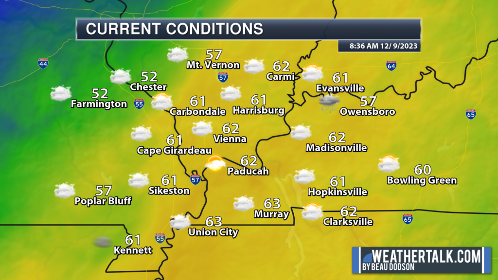
8:55 AM
Dew points are in the upper 50s and near 60 degrees. The yellow zone is where 60 degree and above dew points are located.
Remember, during the winter months we typically look for 58 degrees and above when forecasting severe weather. That isn’t to say you can’t have severe weather with lower dew points, but the odds increase with each degree at 58 and above.
That plume of 60-degree dew points is slowly oozing north and east. We will need to monitor that as we move through the day.
8:34
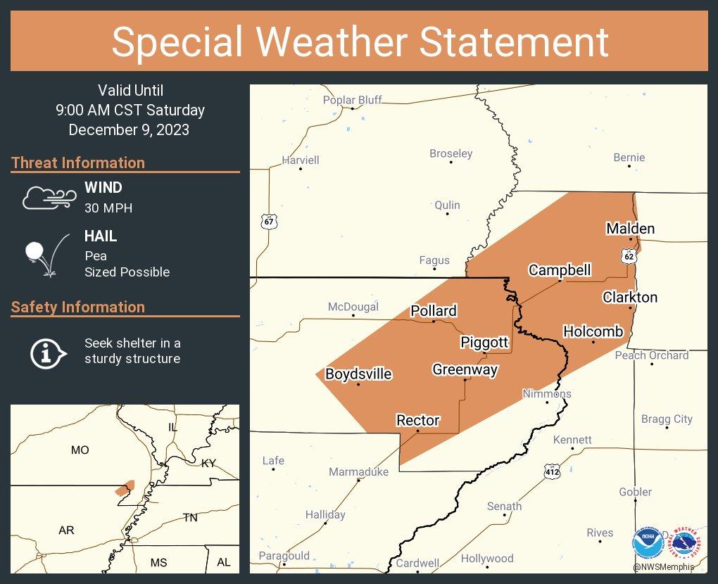
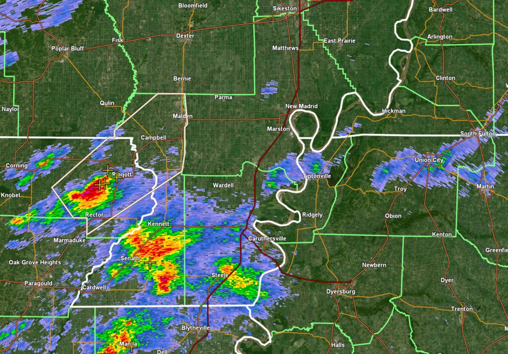
A STRONG THUNDERSTORM WILL IMPACT EASTERN CLAY AND NORTHEASTERN
DUNKLIN COUNTIES THROUGH 900 AM CST…
At 829 AM CST, Doppler radar was tracking a strong thunderstorm near
Rector, moving northeast at 45 mph.
HAZARD…Winds in excess of 30 mph and pea size hail.
SOURCE…Radar indicated.
IMPACT…Gusty winds could knock down tree limbs and blow around
unsecured objects. Minor hail damage to vegetation is
possible.
Locations impacted include…
Malden, Piggott, Campbell, Rector, Chalk Bluff Natural Area,
Clarkton, Holcomb, St. Francis, Pollard, Greenway, Saint Francis,
Crockett, Heubner, Pratt, Carryville, Rhyne, Hargrave Corner, Valley
Ridge, Chalk Bluff Battlefield Park, and Baird.
PRECAUTIONARY/PREPAREDNESS ACTIONS…
If outdoors, consider seeking shelter inside a building.
8:15 AM UPDATE. The next update will be issued at 9:15 AM.
If you haven’t subscribed to www.weathertalk.com then take a minute and do that. Then, download the Beau Dodson Weather app. I will be sending out messages today.
Sample of what I send out to subscribers.
Apple users: Beau Dodson Weather App
https://wtalk.co/9EZYG8A8
Android users: Beau Dodson Weather App
https://wtalk.co/ZEWYU8ME
Beau Dodson Radars and Lightning Data
Interactive local city-view radars. Clickable watches and warnings.
https://wtalk.co/B3XHASFZ
Backup radar site in case the above one is not working.
https://weathertalk.com/morani
Regional Radar
https://imagery.weathertalk.com/prx/RadarLoop.mp4
*NEW* Zoom interactive radar (with storm chaser streams)
https://wtalk.co/AVWG7GM7
Real time lightning tracker system two. https://map.blitzortung.org/#5.02/37.95/-86.99
Lightning Data (zoom in and out of your local area)
https://wtalk.co/WJ3SN5UZ
8:15 AM UPDATE. The next update will be issued at 9:15 AM.
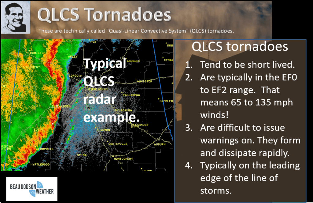
What? A few of today’s thunderstorms could produce 60 mph wind gusts and nickel size hail. Lightning, as well. There is a low-end risk of QLCS tornadoes. QLCS tornadoes are difficult to issue warnings on. They develop fast, are embedded in the rain, and often only last a few minutes. Remember, it only takes one tornado to ruin the day.
When? I am watching this morning through the afternoon. The risk will end west to east with the passing hours. As the cold front moves eastward, the threat of severe weather will end. I will post updates here throughout the day.
Where? The primary concern zone will be from the Missouri Bootheel into western Kentucky and Tennessee. Perhaps extreme southern Illinois.
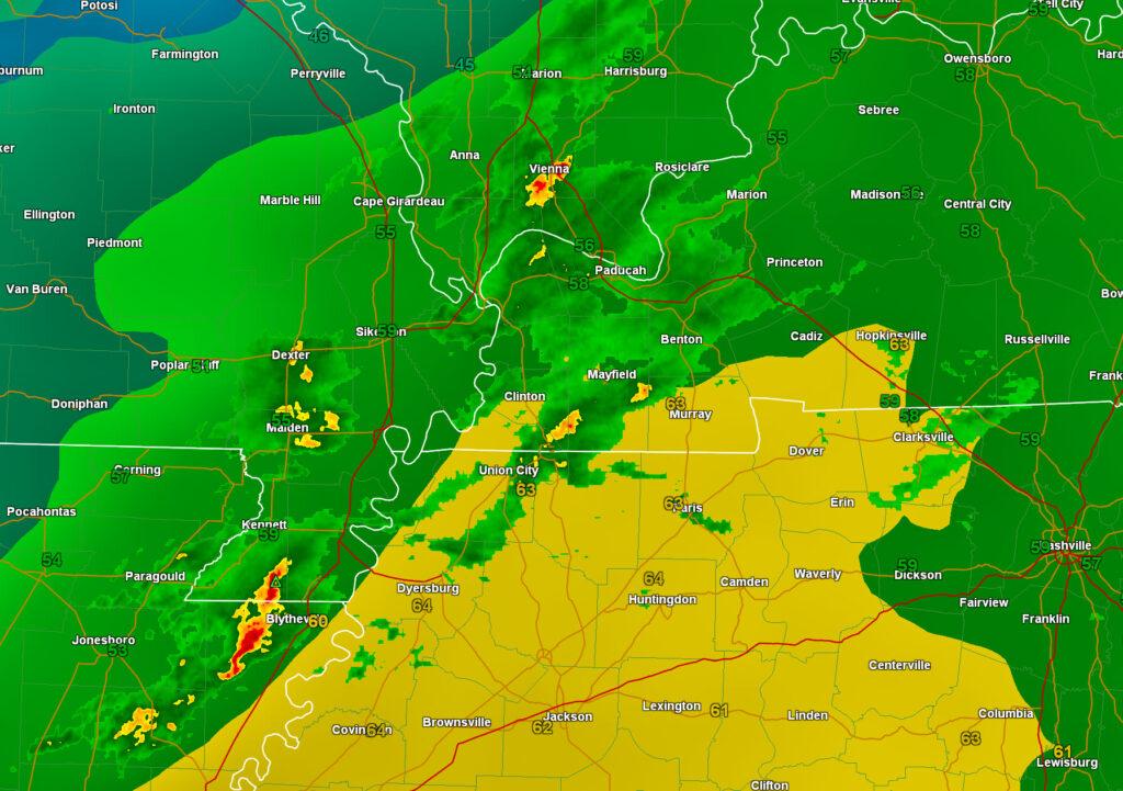
I am tracking the risk of a few severe thunderstorms today. Mainly from the Missouri Bootheel into western Kentucky and Tennessee. Lower chances north and west.
The Storm Prediction Center has issued a level one and two risk for our region. The light green zone is where sub-severe storms are possible. The dark green is the level one out of five risk zone. The yellow is the level two out of five risk zone. Five is the highest risk the SPC issues.
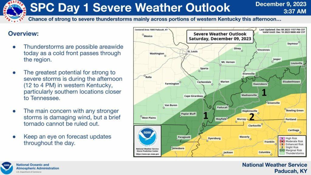
The primary concern will be damaging wind and short-lived QLCS tornadoes.
What are two QLCS tornadoes? They tend to only last a few minutes. They can cause damage.
The primary timeframe of concern will be this morning into the afternoon hours. A couple rounds of storms will be possible.
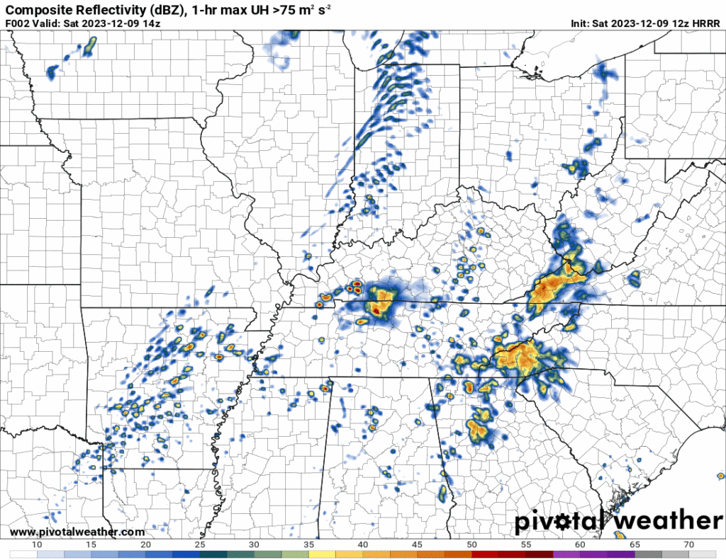
Let me show you the future-cast radar from the Hrrr model. One model of many. This is what radar might look like today. Remember, models are not exact. Take the general idea from this animation.
Timestamp upper left. Zulu time. 12z=6 am. 18z=12 pm. 20z=2 pm. 22z=4 pm. 00z=6 pm. 02z=8 pm.
At 8:15 AM radar shows some strong storms entering the Missouri Bootheel.
Here is the radar loop from around 8 am. See the live radar links at the top of the page.
We are going to see numerous showers and thunderstorms move east northeast through the region today.
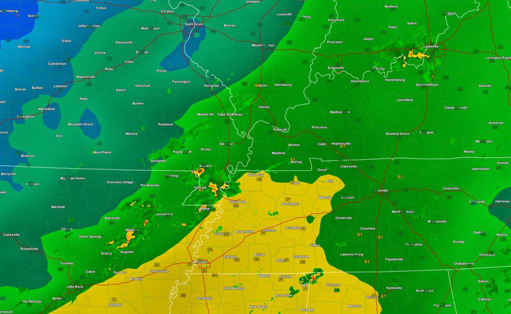
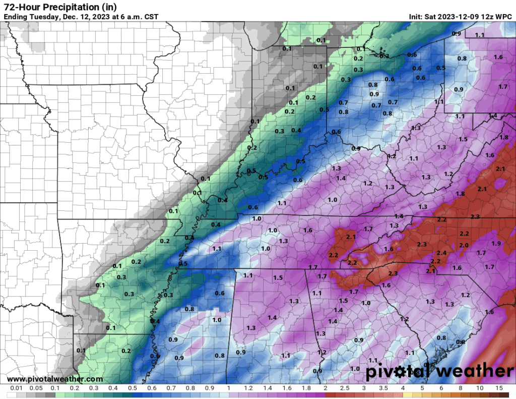
Rainfall totals through tomorrow. You can see the sharp cutoff to the north and west.
Stay weather aware today. I will be sending out Beau Dodson Weather App messages.
Remember, a WARNING is MORE serious. A watch just means to go about your business and monitor updates.
A WARNING means to seek shelter.
Tornado Safety