UPDATE:
News First is in Storm Alert Mode with LIVE updates by Chief Meteorologist Beau Dodson in our Weather Center. Click HERE to go there now.
…A TORNADO WARNING REMAINS IN EFFECT UNTIL 215 PM CST FOR SOUTHERN CHRISTIAN AND SOUTHERN TODD COUNTIES…
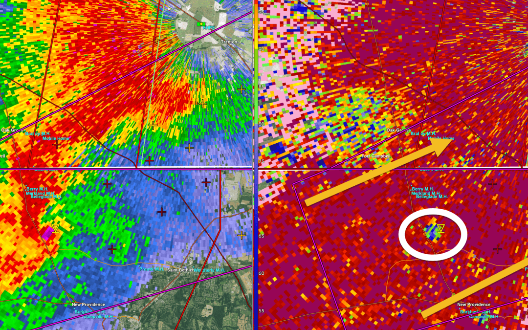
At 150 PM CST, a confirmed large and extremely dangerous tornado was located near Clarksville, moving northeast at 45 mph. This tornado will cross Interstate 24 near the Kentucky Tennessee line by 155 pm.
This is a PARTICULARLY DANGEROUS SITUATION. TAKE COVER NOW!
HAZARD…Damaging tornado.
SOURCE…Weather spotters confirmed tornado.
IMPACT…You are in a life-threatening situation. Flying debris may be deadly to those caught without shelter. Mobile homes will be destroyed. Considerable damage to homes, businesses, and vehicles is likely and complete destruction is possible. The tornado will be near… Guthrie around 155 PM CST. This includes Interstate 24 in Kentucky between Mile Markers 91 and 92.
PRECAUTIONARY/PREPAREDNESS ACTIONS… To repeat, a large, extremely dangerous and potentially deadly tornado is on the ground. To protect your life, TAKE COVER NOW! Move to a basement or an interior room on the lowest floor of a sturdy building. Avoid windows. If you are outdoors, in a mobile home, or in a vehicle, move to the closest substantial shelter and protect yourself from flying debris.
PREVIOUS
…A TORNADO WARNING REMAINS IN EFFECT UNTIL 215 PM CST FOR NORTHEASTERN MONTGOMERY COUNTY…
At 146 PM CST, a confirmed tornado was located near Clarksville, moving northeast at 35 mph.
HAZARD…Damaging tornado.
SOURCE…Public confirmed tornado.
IMPACT…Flying debris will be dangerous to those caught without shelter. Mobile homes will be damaged or destroyed. Damage to roofs, windows, and vehicles will occur. Tree damage is likely. This tornado will be near… Clarksville and Clarksville around 150 PM CST. This includes Interstate 24 between mile markers 1 and 6.
PRECAUTIONARY/PREPAREDNESS ACTIONS… To repeat, a tornado is on the ground. TAKE COVER NOW! Move to a basement or an interior room on the lowest floor of a sturdy building. Avoid windows. If you are outdoors, in a mobile home, or in a vehicle, move to the closest substantial shelter and protect yourself from flying debris.
The National Weather Service in Paducah has issued a
* Tornado Warning for…
Southeastern Christian County in south central Kentucky…
Southern Todd County in south central Kentucky…
* Until 215 PM CST.
* At 144 PM CST, a tornado producing storm was located near Clarksville, moving northeast at 45 mph.
HAZARD…Damaging tornado. SOURCE…Radar confirmed tornado. IMPACT…Flying debris will be dangerous to those caught without shelter. Mobile homes will be damaged or destroyed. Damage to roofs, windows, and vehicles will occur. Tree damage is likely. * This tornadic storm will be near… Oak Grove and Guthrie around 150 PM CST. This includes Interstate 24 in Kentucky between Mile Markers 89 and 92.