Posted by Meteorologist Beau Dodson
Friday Weather Update
Confidence in the overall forecast today through Saturday night? High.
What? Rain and snow showers moving into the region this afternoon and tonight.
When? This afternoon and tonight. Peak precipitation chances will be after 3 PM and before 3 AM. A few scattered showers and/or snow showers will be possible Saturday and Saturday night, as well.
Where? Area-wide.
Snow totals? A light slushy dusting of snow will be possible from Butler County, Missouri northeast to Bollinger County, Missouri and then northeast towards Jefferson County, Illinois. The rest of the region has little or no chance of accumulating snow.
Impacts? A few roads could become slick over southeast Missouri and southwest Illinois. I encourage you to monitor air temperatures late at night and during the morning hours. If they dip below freezing then be careful on bridges, overpasses, decks, and porches. Elevated surfaces could briefly freeze. Road temperatures are fairly warm. This will help prevent impacts. The road department, in some areas, will be salting, as well.
Forecast Discussion
First off, I did send this out to my Weather Talk subscribers.
Counties
Butler, Stoddard, Bollinger, Cape Girardeau, Perry, and Ste Genevieve Counties
Randolph, Perry, Jackson, Franklin, Union, Hamilton, Williamson, and Jefferson Counties
A rain/snow mix will move into southeast Missouri and southern Illinois this afternoon and tonight. Temperatures tonight will likely drop to near freezing.
It is possible that Stoddard, Cape Girardeau, Union, Williamson, Franklin, and Hamilton Counties remain mostly rain. I included them as a buffer zone along the area with a higher chance of snow (to the west/northwest).
A slushy accumulation of a dusting to an inch or so of snow will be possible in the above mentioned counties. The farther west/northwest you travel, the higher the probabilities for light accumulating snow.
Remember, bridges and overpasses freeze first. Some slick spots will be possible tonight into early tomorrow morning.
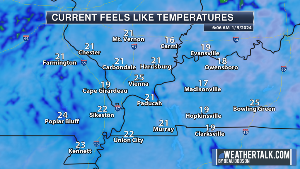
Good morning, everyone. We are waking up to chilly temperatures.
Here was the 7 AM feels like temperatures. Brrr.
Clouds are once again thickening and lowering.
The 7 AM NWS radar already shows widespread rain and snow across western Missouri and Arkansas. This is moving northeast.
Green is rain. Blue is snow. Yellow is moderate rain. Pink/red represents a wintry mix.
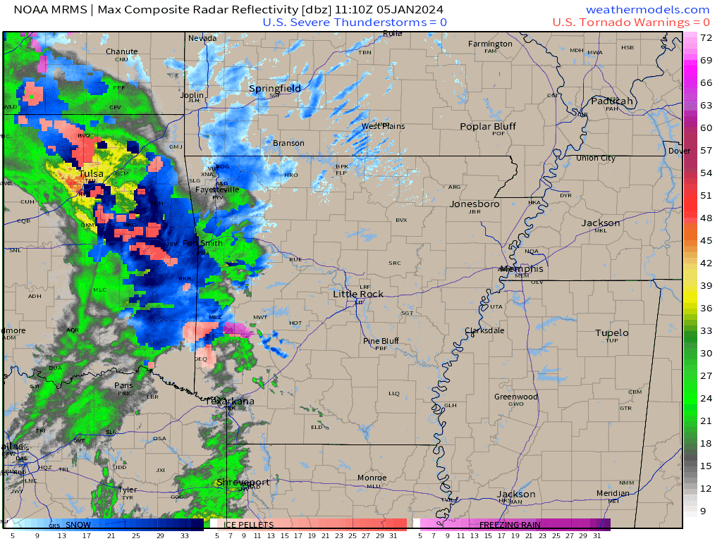
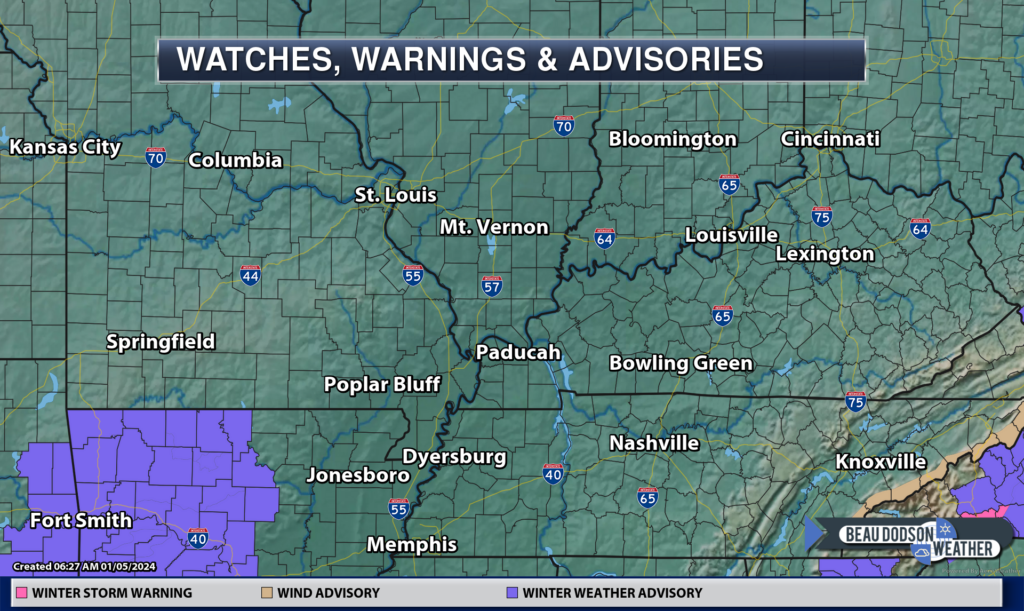
A winter weather advisory has been issued for portions of Arkansas. I will be watching southeast MO and southern IL for icy roads tonight.
Let’s take a look at a future-cast radar. This is the Hrrr model. A high resolution model. This is what radar will likely look like today into tonight.
Green is rain. Blue is snow.
Time s zulu. 12z=6 am. 18z=12 pm. 00z=6 pm. 06z=12 am.
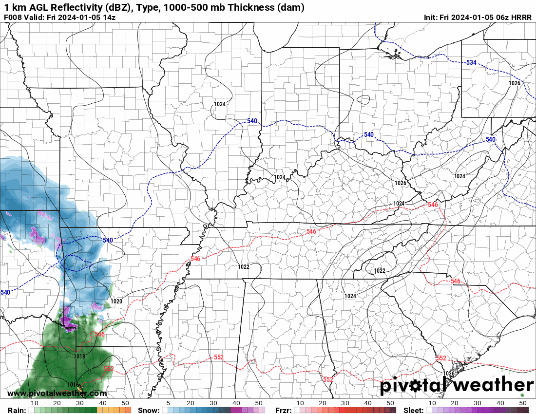
The bulk of this rain event will be over by late tonight and tomorrow morning.
A second light wave of precipitation is possible late Saturday afternoon and night. That could be a rain/snow mix, as well. Accumulation is not anticipated.
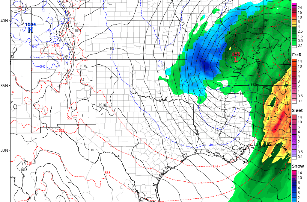
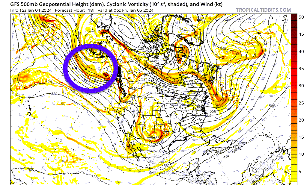
I continue to track a larger storm system next week. The model guidance has been fairly steady on the track of this system. Taking the area of low pressure over southeast Missouri and southern Illinois.
That would place the higher chances for snow accumulation across central and northern Missouri and central and northern Illinois.
If the low tracks a bit farther southeast, then the rain/snow line would shift southeast, as well. Confidence in the final forecast will increase over the next day or two.
Keep in mind, this system is still out over the Pacific Ocean. Once it moves onshore, the models will have a better sampling of the atmospheric conditions around it.
Hurricane hunters are going to fly into the system later today. They will be sampling data and ingesting it into the models.
Here is where the system was located (as of 7 AM Friday).
Monitor updates over the next couple of days.
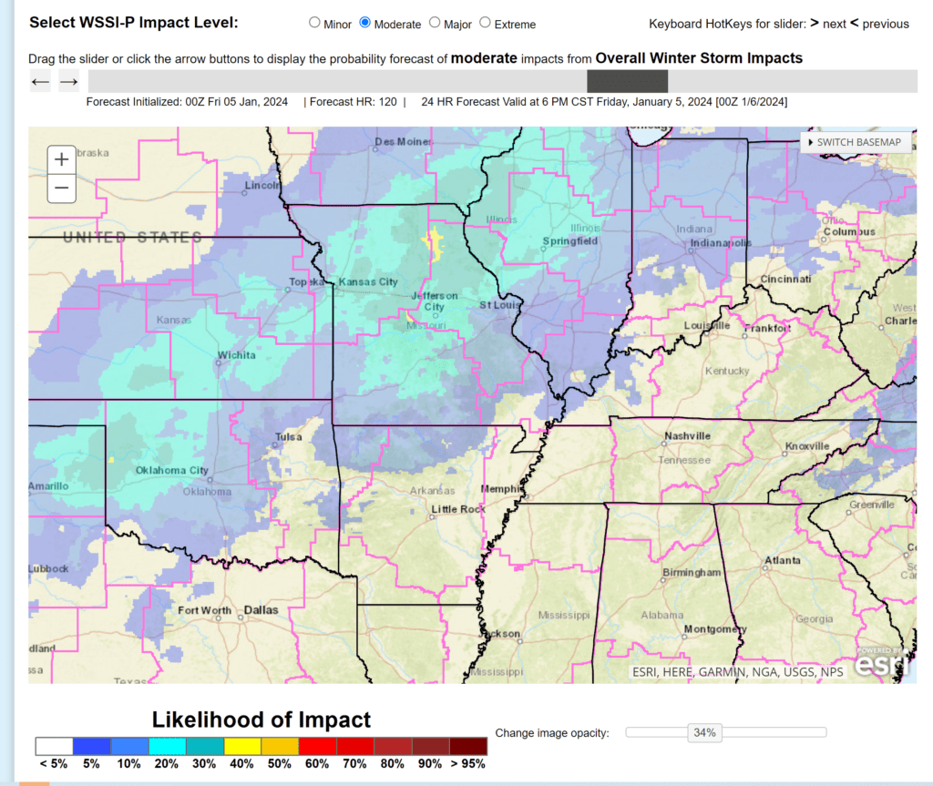
Currently the WPC has this area outlined for minor impacts from snow next Monday afternoon into Tuesday night.
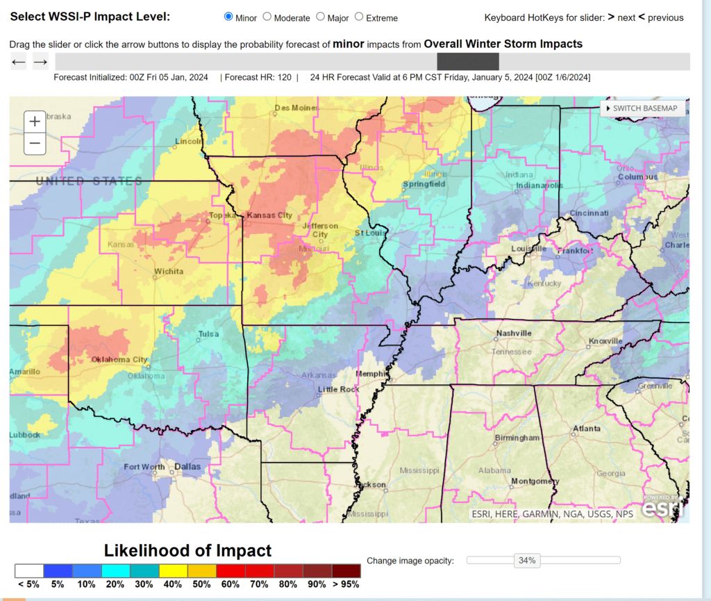
Here is where moderate impacts are anticipated. As you can see, currently it appears the risk level is higher from south central Kansas into central and northern Missouri and then into central and northern Illinois.
Widespread rain.
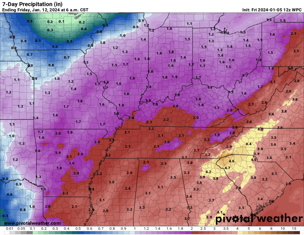
One thing is for certain, widespread rain will move into our region Monday and Monday night. That will continue into Tuesday and Tuesday night.
How much rain is anticipated with the system next week? Here you go. We need this rain. We are in drought.
Beau Dodson Weather Radars and Lightning Data
Click the winterize button on the local city view radars to see precipitation type.
Interactive local city-view radars. Clickable watches and warnings. Winterize button.
https://beaudodsonweather.com/weather-radars/
Backup radar site in case the above one is not working.
https://weathertalk.com/morani
Regional Radar
https://imagery.weathertalk.com/prx/RadarLoop.mp4
*NEW* Zoom interactive radar (with storm chaser streams)
https://wtalk.co/AVWG7GM7
Real time lightning tracker system two.https://map.blitzortung.org/#5.02/37.95/-86.99
Lightning Data (zoom in and out of your local area)
https://wtalk.co/WJ3SN5UZ
Want to receive more weather information? I provide a service through www.weathertalk.com
Subscribe at www.weathertalk.com and then download the Beau Dodson Weather app from the app stores!
Apple users: Beau Dodson Weather App
https://wtalk.co/9EZYG8A8
Android users: Beau Dodson Weather App
https://wtalk.co/ZEWYU8ME
Need help? Email me at beaudodson@usawx.com
* Daily weather forecasts
* My personal weather blog with all sorts of weather information!
* Special weather statements sent to the Beau Dodson Weather app.
* Rapid fire tornado alerts.
* Severe weather alerts and forecasts.
* Severe weather updates throughout the day (when severe weather is occurring)
* Ice storm alerts and forecasts.
* Winter storm alerts and forecasts.
* Winter storm updates throughout the event.
* Regional weather videos.
* Long range weather videos.
* A daily forecast that I hand type for your county. Sent out every afternoon.
* Long range outlooks. Including week one, two, three, four, and monthly outlooks. Seasonal outlooks.
* App messages to alert you when I have updated the weather blogs and Facebook.
* And more!
Here are some examples of what people receive when they subscribe to www.weathertalk.com