Posted by Meteorologist Beau Dodson
Want to receive more weather information? I provide a service through www.weathertalk.com
Subscribe at www.weathertalk.com and then download the Beau Dodson Weather app from the app stores!
Apple users: Beau Dodson Weather App
https://wtalk.co/9EZYG8A8
Android users: Beau Dodson Weather App
https://wtalk.co/ZEWYU8ME
Need help? Email me at beaudodson@usawx.com
Good day, everyone.
I hope you are enjoying your weekend. A bit cool outside, but hey it is January! No complaints. It has been a mild winter, thus far.
Over the past week, I have been tracking a major winter storm (blizzard) for Monday and Tuesday. I have been carefully tracking where the center of low pressure would pass.
Confidence continues to increase that the low will track over the St Louis area. That keeps our region in the warm sector.
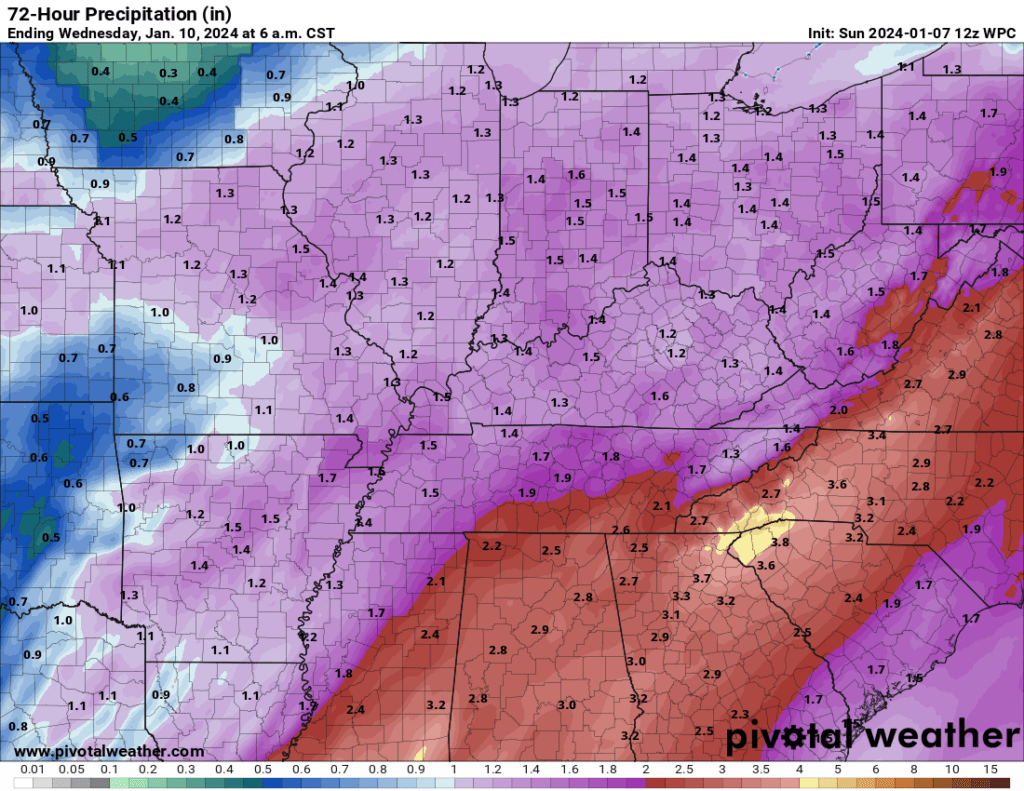
You can expect widespread rain to arrive Monday afternoon and night. That will continue into Tuesday. Ending Tuesday night. A few claps of thunder will be possible, as well.
Gusty winds tonight into Wednesday. Occasional gusts to 40 mph will be possible.
Rain totals will exceed an inch in some counties. We need this rain! We are in drought.
The rain may end as a brief period of snow showers Tuesday night as temperatures fall into the 20s and 30s. Little or no accumulation. Perhaps a dusting in a few spots (mainly MO/IL). Don’t get overly excited snow lovers! This is not our winter storm (at least the white part).
Here is the latest rainfall outlook. How much rain can you expect Monday PM into Tuesdasy PM? I am forecast .75 to 1.5″. Here is the NOAA map.
Enjoy the winter rain! We need it.
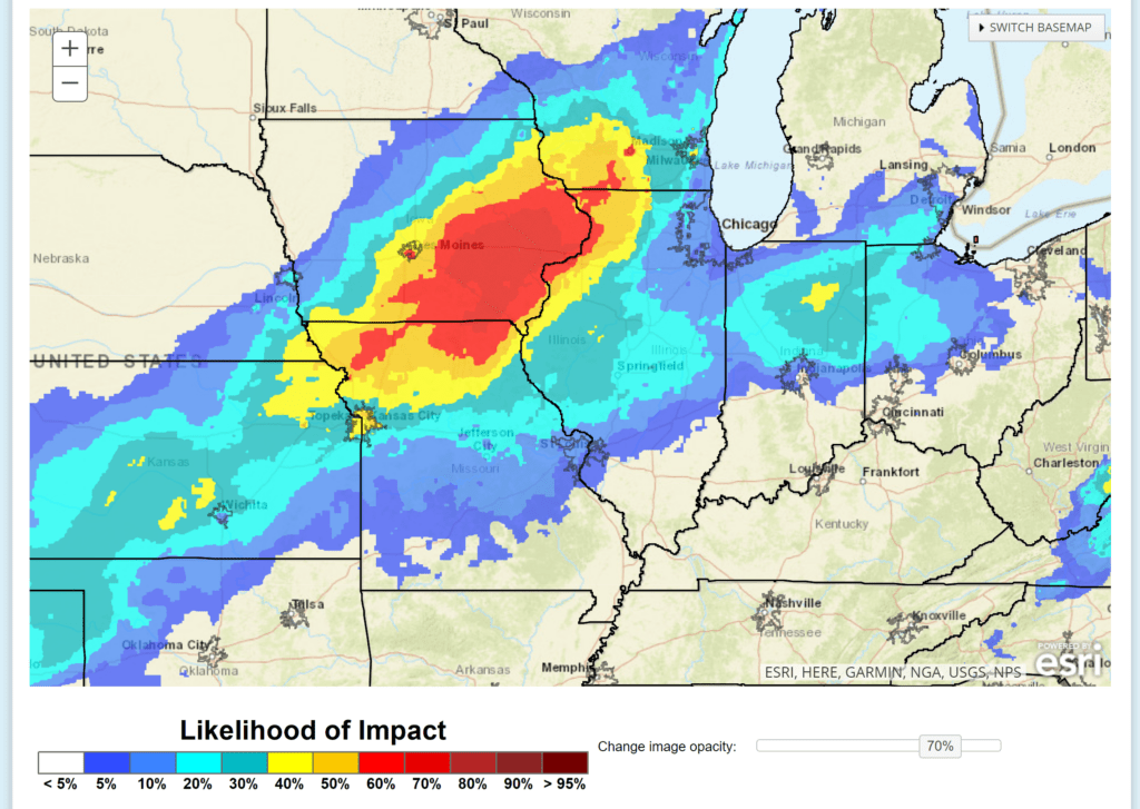
If you have travel plans to the west and north, then check ahead. Icy road conditions are likely early this week over portions of MO/IL.
Moderate winter storm impacts are likely in this area (especially the yellow to red zone).
I am tracking another major winter storm later this week. Too soon to know the path of the low-pressure center. I have precipitation in the forecast late Thursday night into Friday night.
Stay tuned. Have a great week.
Beau Dodson Weather Radars and Lightning Data
Click the winterize button on the local city view radars to see precipitation type.
Interactive local city-view radars. Clickable watches and warnings. Winterize button.
https://beaudodsonweather.com/weather-radars/
Backup radar site in case the above one is not working.
https://weathertalk.com/morani
Regional Radar
https://imagery.weathertalk.com/prx/RadarLoop.mp4
*NEW* Zoom interactive radar (with storm chaser streams)
https://wtalk.co/AVWG7GM7
Real time lightning tracker system two.https://map.blitzortung.org/#5.02/37.95/-86.99
Lightning Data (zoom in and out of your local area)
https://wtalk.co/WJ3SN5UZ
Want to receive more weather information? I provide a service through www.weathertalk.com
Subscribe at www.weathertalk.com and then download the Beau Dodson Weather app from the app stores!
Apple users: Beau Dodson Weather App
https://wtalk.co/9EZYG8A8
Android users: Beau Dodson Weather App
https://wtalk.co/ZEWYU8ME
Need help? Email me at beaudodson@usawx.com
* Daily weather forecasts
* My personal weather blog with all sorts of weather information!
* Special weather statements sent to the Beau Dodson Weather app.
* Rapid fire tornado alerts.
* Severe weather alerts and forecasts.
* Severe weather updates throughout the day (when severe weather is occurring)
* Ice storm alerts and forecasts.
* Winter storm alerts and forecasts.
* Winter storm updates throughout the event.
* Regional weather videos.
* Long range weather videos.
* A daily forecast that I hand type for your county. Sent out every afternoon.
* Long range outlooks. Including week one, two, three, four, and monthly outlooks. Seasonal outlooks.
* App messages to alert you when I have updated the weather blogs and Facebook.
* And more!
Here are some examples of what people receive when they subscribe to www.weathertalk.com