Posted by Meteorologist Beau Dodson
** The winter storm event is still six days away. Typically, an accurate snow forecast is made 24 to 48 hours out. Thus, we still have several days to watch this event. **
Want to receive more weather information? I provide a service through www.weathertalk.com
Subscribe at www.weathertalk.com and then download the Beau Dodson Weather app from the app stores!
Apple users: Beau Dodson Weather App
https://wtalk.co/9EZYG8A8
Android users: Beau Dodson Weather App
https://wtalk.co/ZEWYU8ME
Well, winter is about to dance its way into the region.
First, we will have gusty winds today into early next week. Twenty to thirty mph wind will be common. Occasional gusts above 40 mph are also a possibility (especially today and tonight and then again Friday/Friday night).
We have another soaking rain event developing Thursday night into Friday. Thunderstorms are likely, as well. At this time, we expect the severe weather to remain to our south.
Another inch or so of rain will be possible Thursday afternoon/night into Friday afternoon.
The Friday storm will be a blizzard or near blizzard for portions of Missouri and Illinois. Mainly to the north and west of my forecast counties. If you are traveling northward, then monitor updates.
The rain will likely end as snow showers Friday afternoon and night, and this could drop a dusting to an inch or so of snow in our local area. The primary concern will be southeast Missouri into southern Illinois and then into northwest Kentucky.
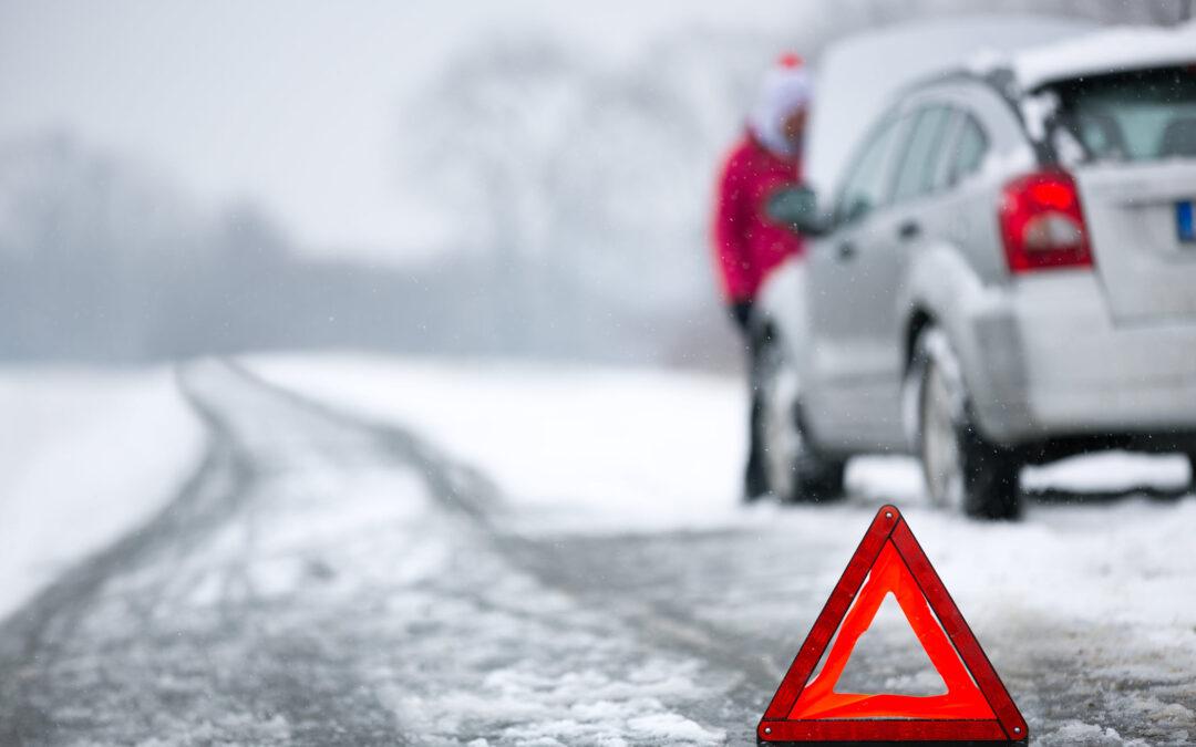
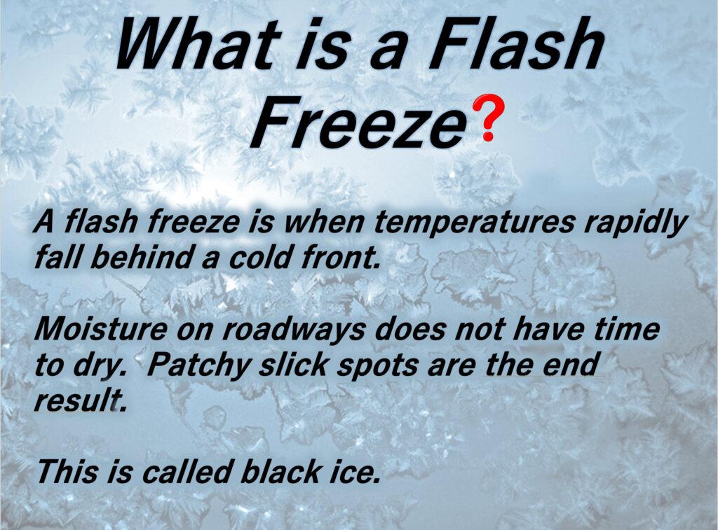
Rapidly falling temperatures will lead to a flash freeze Friday afternoon and night, as well. Watch for slick spots on roadways and parking lots. Snow showers would enhance the concern.
Gusty winds could help dry surfaces. If that were to happen then the risk of icy roads will be lower. Monitor updates if you have travel plans Friday PM into Saturday morning.
Bitterly cold air trickles into the region Friday night and that cold air is going to linger into next week.
This is pipe busting cold.
Lows Friday night will dip into the teens and twenties. Low Saturday night will dip into the teens. Lows Sunday and Monday night will dip into the single digits and teens. Lows Tuesday night will dip into the single digits and teens.
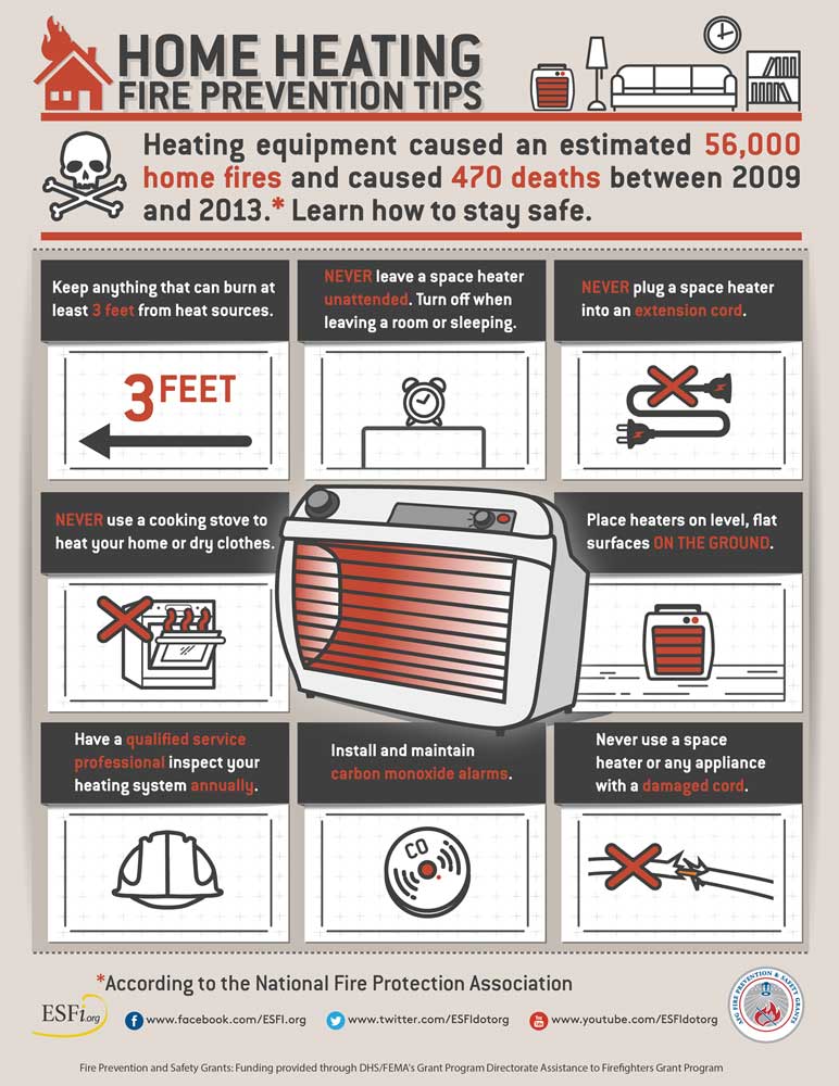
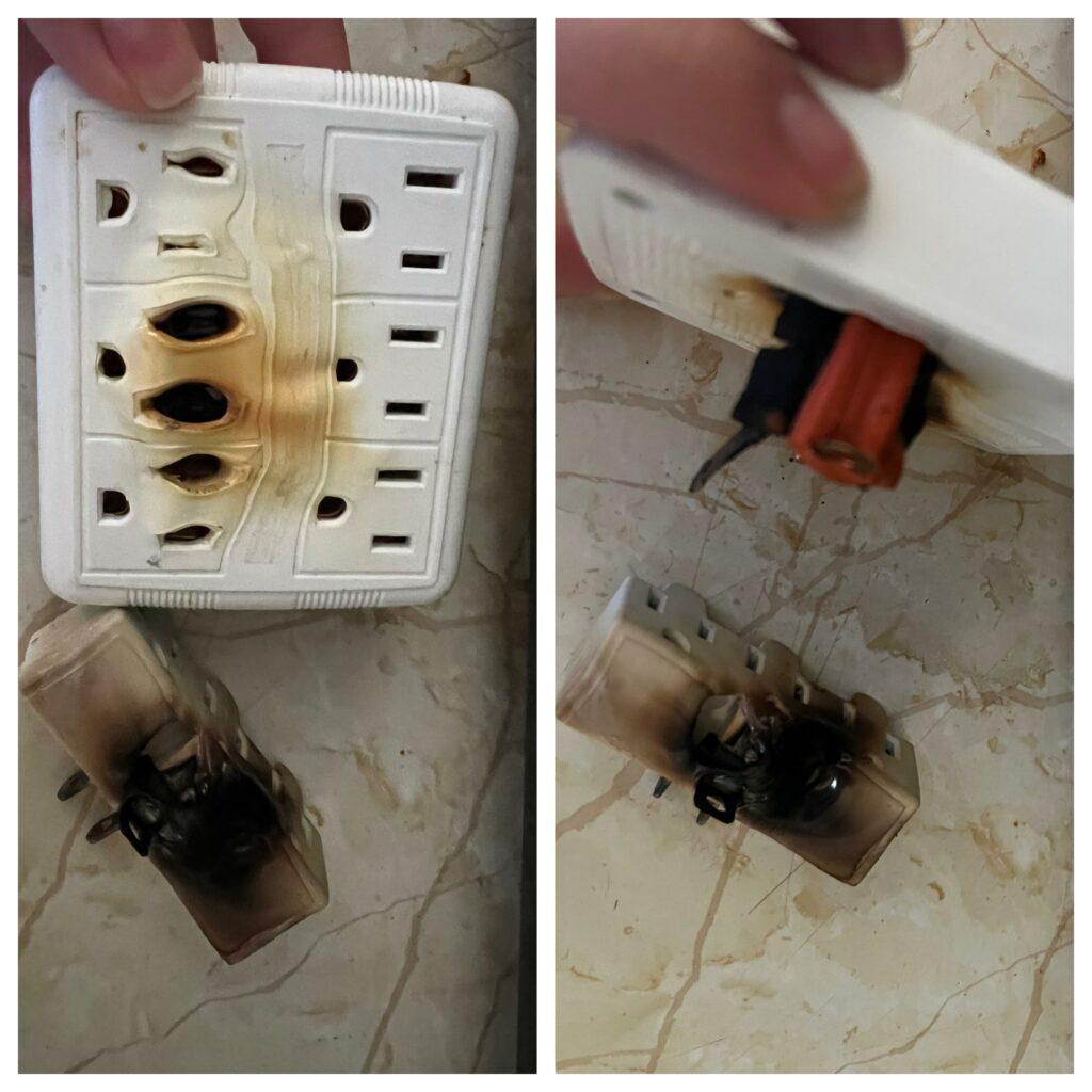
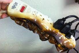
This type of prolonged cold snap typically leads to increased house fires and pipes busting.
Avoid extension cords with space heaters. Every year our region experiences house fires, because of this.
Possible Winter Storm Sunday Afternoon into Monday
Our next chance of precipitation arrives late Sunday into Monday. This has the highest potential of bringing wintry precipitation to our local area. This is the first time this winter that I have thought we might actually experience some frozen precipitation.
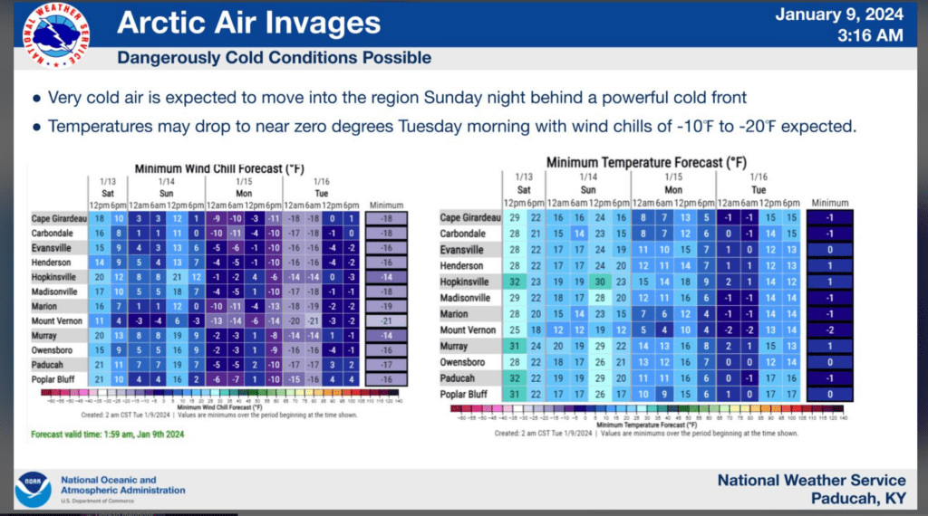
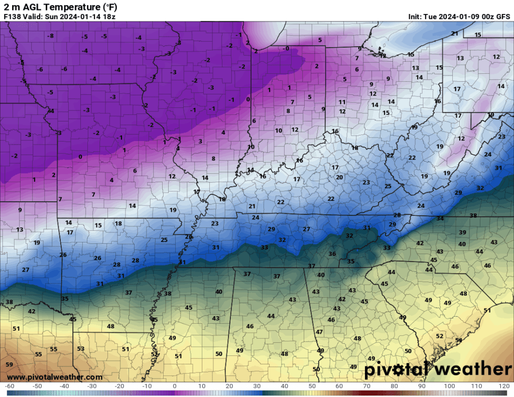
Bitterly cold air will be pushing into the region from the north.
You can see that here. This is the Sunday afternoon temperature forecast. Brrr and double brrr. Check out all those single digits to our north. Even below zero! Those are actual air temperatures. Wind chill values will be even colder.
That cold arctic air will continue to ooze southward with time.
How far south the cold air pushes is key to where snow and sleet will fall late Sunday into Monday.
Models do not handle cold air all that well. They tend to underplay it. The trend has been to push this cold air farther and farther south and east. That also pushes the snow farther south and east.
At this time, it appears some accumulating snow will likely impact the region late Sunday into Monday. It is a bit too soon for totals, but a few inches is a good bet for portions of the area.
The risk of accumulating snow is highest from southern Missouri/northern Arkansas and then east northeast into western Kentucky and Tennessee. As you travel farther north and west, the chances for higher snow totals will decrease.
Again, it is a bit early to certainties. The event is still several days away. If the cold air pushes too far south and east, then the snow chances will be shunted away from our region.
Typically, an accurate snowfall forecast is made 24 to 48 hours before the event arrives. We still have a few days to go.
I doubt the cold air will push far enough south to cause the system to completely miss us, but at least our northern counties may be at risk for much lower snow totals.
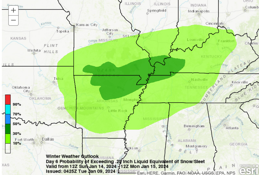
Currently this is where NOAA has the highest chance of 3 to 6 inches of snow. The dark green zone. I will be watching for shifts on this graphic over the next few days. This is their starting point. This may trend south and east as new data arrives.
The cold air will likely make this a fluffy dry snow. Snow ratios will be high. Typically, we see snow ratios of 10:1. This event may produce 20:1 or higher.
What does 10:1 ratio mean? It means for every one inch of liquid precipitation ten inches of snow accumulates. A 20:1 ratio would mean one inch of liquid precipitation equals twenty inches of snow.
We aren’t forecasting ten to twenty inches of snow, but I am just informing you on how the snow ratio system works.
What does fall isn’t going to melt. Bitterly cold air will keep roads slick and hazardous for several days.
There are a lot of moving parts to the forecast. Monitor updates.
Want to receive more weather information? I provide a service through www.weathertalk.com
Subscribe at www.weathertalk.com and then download the Beau Dodson Weather app from the app stores!
Apple users: Beau Dodson Weather App
https://wtalk.co/9EZYG8A8
Android users: Beau Dodson Weather App
https://wtalk.co/ZEWYU8ME
Need help? Email me at beaudodson@usawx.com
* Daily weather forecasts
* My personal weather blog with all sorts of weather information!
* Special weather statements sent to the Beau Dodson Weather app.
* Rapid fire tornado alerts.
* Severe weather alerts and forecasts.
* Severe weather updates throughout the day (when severe weather is occurring)
* Ice storm alerts and forecasts.
* Winter storm alerts and forecasts.
* Winter storm updates throughout the event.
* Regional weather videos.
* Long range weather videos.
* A daily forecast that I hand type for your county. Sent out every afternoon.
* Long range outlooks. Including week one, two, three, four, and monthly outlooks. Seasonal outlooks.
* App messages to alert you when I have updated the weather blogs and Facebook.
* And more!
Here are some examples of what people receive when they subscribe to www.weathertalk.com