Posted by Meteorologist Beau Dodson
Another storm system will pull into the Ohio and Tennessee Valleys beginning tonight and lingering into Monday night.
This will be a widespread rain event for the region. Some thunderstorms will be embedded in the rain, as well.
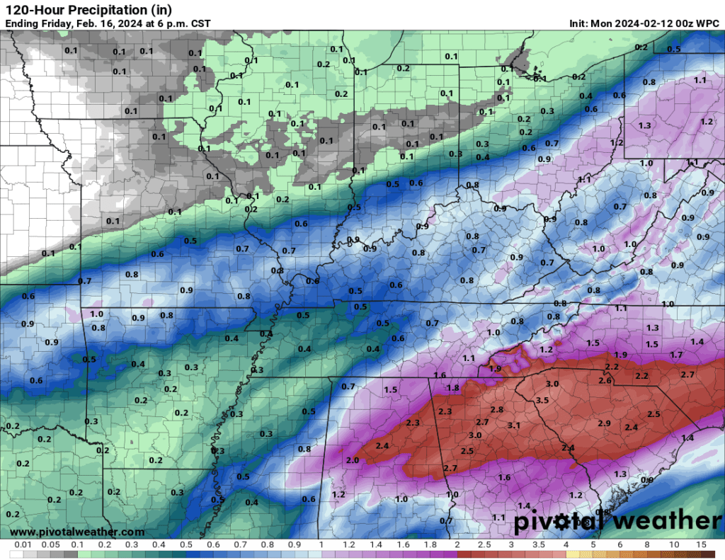
Expected rain totals.
On the backside of the area of low pressure there will be a narrow band of wet snow. Perhaps heavy wet snow. Ground and road conditions are mild. This will make it difficult for the snow to stick.
With that said, if the snow comes down heavy enough, then it will likely overcome the warm ground conditions. If you have one to two inch per hour snow rates, then it will stick. It won’t matter how warm the ground is. I have seen it many times.
I have also witnessed events like this exceed expectations. Several inches of wet snow will be possible in the heaviest band. That would be a narrow band. Perhaps fifteen to twenty miles wide.
The highest probability of heavier snow totals will likely be somewhere in southeast Missouri. Perhaps even exceeding four inches. Farther east northeast will need to monitor.
Models have been useless with this event. Showing snow all that way from near the Missouri Bootheel to St Louis. Fluctuating between that area.
Unfortunately, we may not have a handle on the placement of the heaviest snow band until the event is underway. The primary concern will be elevated surfaces. Those will have a higher chance of accumulating snow. Grassy surfaces, bridges, and overpasses.
Again, if the snow comes down at a rate of one to two inches per hour, then it would also stick to roadways. Occasionally, these types of events stick to roadways and then melt after the precipitation ends.
My overall confidence in this event is low.
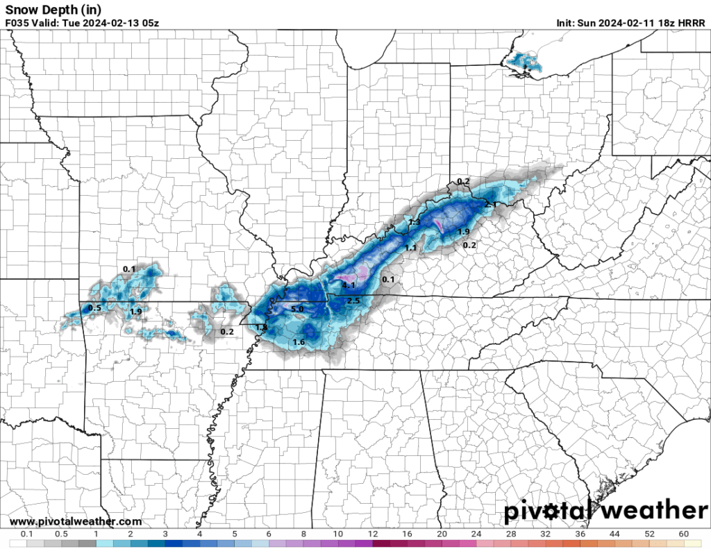
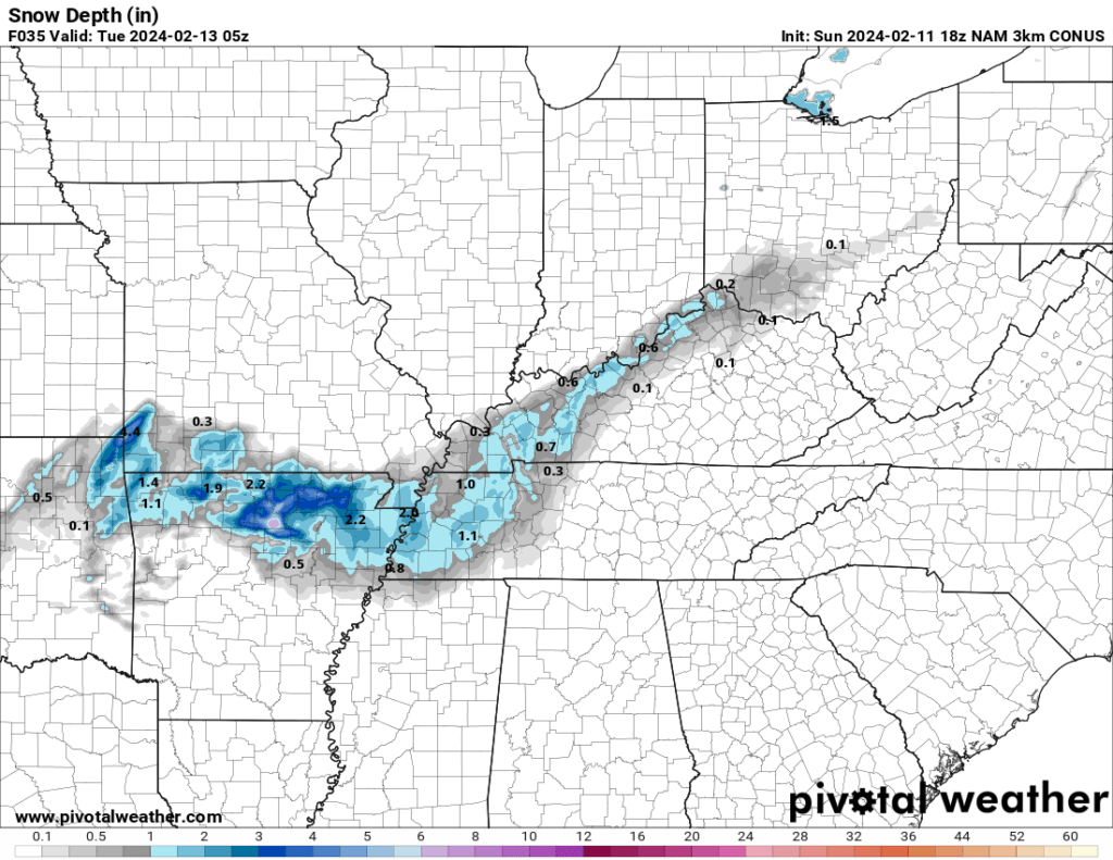
This afternoon, models trended south with the accumulating snow.
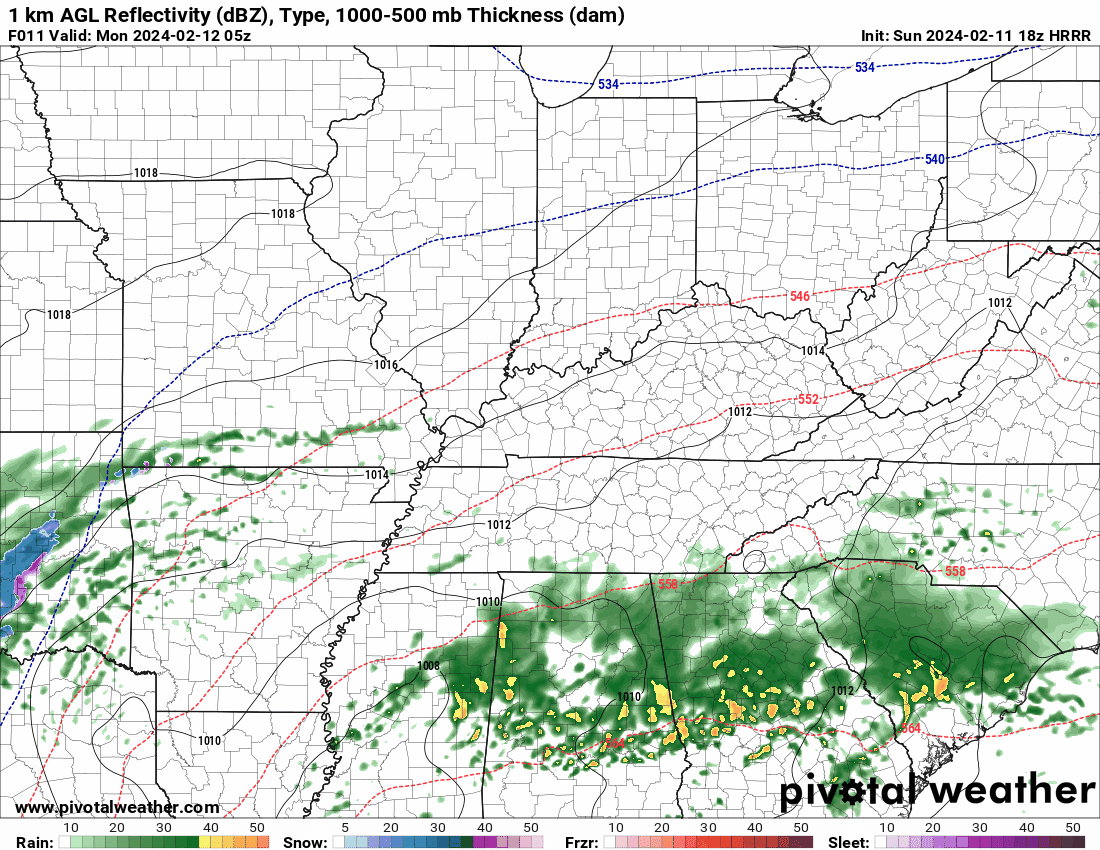
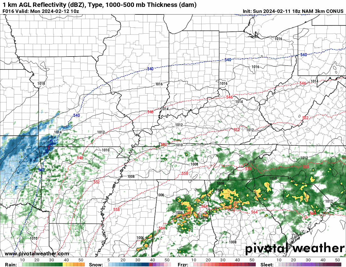
For example, here is the Hrrr and NAM models. This is where they place the band of accumulating snow. This seems too far south, but let’s keep an eye on it. Ignore the model totals. Just showing you placement.
Earlier this morning, this is where they showed the accumulating snow. Farther north. Again, ignore the numbers. I am just showing you the placement.
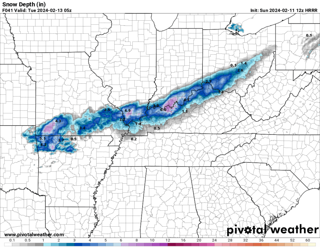
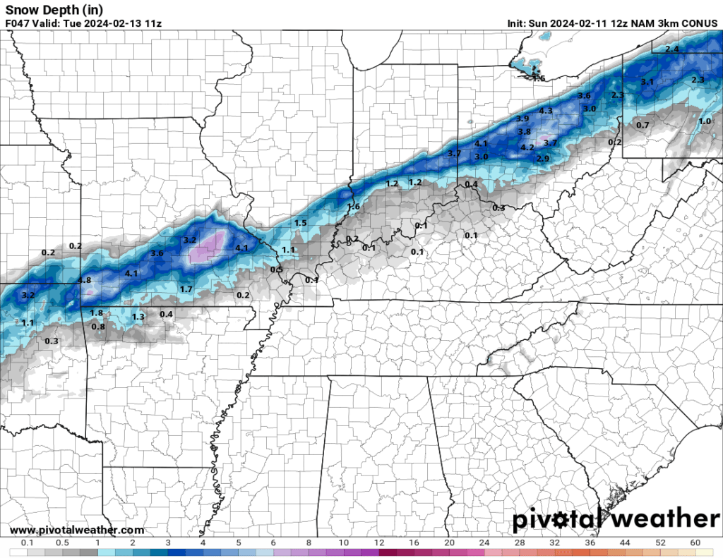
That is quite the shift in 12 hours. That is why I said that I don’t have much confidence in the model output.
I won’t be surprised to see a thin/narrow band of heavy wet snow develop in our region.
Temperatures will likely range from 32 to 35 degrees while the snow is falling. Marginal temperatures.
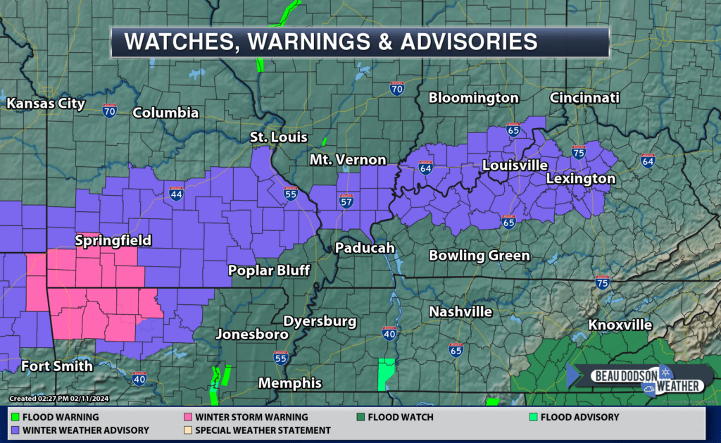
Officially, the NWS has issued winter storm warnings and winter weather advisories for portions of our region. There could still be shifts in this. I believe travel impacts will be short-lived.
The purple zone is the winter weather advisory for an inch or two of snow. Again, adjustments in the placement are still possible.
High temperatures Tuesday will pop into the 40s and 50s. Highs Wednesday will pop into the 50s.
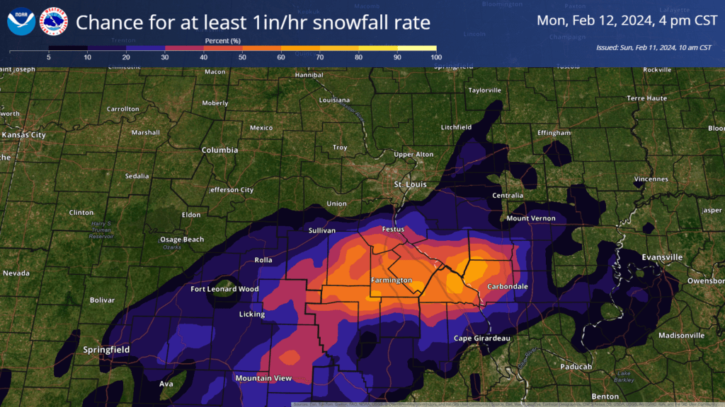
Here is one model that we use when forecasting snow. It shows where a period of heavy snow may occur. With an inch of snow per hour.
Let’s look at some future-cast radars.
Again, these two models trended south in their latest run. Earlier today, they were showing the snow several counties farther to the north.
The Hrrr model Future-cast radar. What radar might look like. The timestamp is in Zulu. 12z=6 am. 18z=12 PM. 00z=6 PM. 06z+12 AM.
The NAM model Future-cast radar. What radar might look like. The timestamp is in Zulu. 12z=6 am. 18z=12 PM. 00z=6 PM. 06z+12 AM.
Needless to say, my confidence in the forecast isn’t great.
Monitor updated forecasts and be prepared for a band of heavy wet snow Monday afternoon and evening. Use care if the snow does briefly accumulate on surfaces.
Beau Dodson Weather Radars and Lightning Data
Interactive local city-view radars.
Clickable watches and warnings.
Winterize button. Click the winterize button to see precipitation type. That button is found on the local city-view radars.
https://beaudodsonweather.com/weather-radars/
Backup radar site in case the above one is not working.
https://weathertalk.com/morani
Regional Radar
https://imagery.weathertalk.com/prx/RadarLoop.mp4
*NEW* Zoom interactive radar (with storm chaser streams)
https://wtalk.co/AVWG7GM7
Real time lightning tracker system two.
https://map.blitzortung.org/#5.02/37.95/-86.99
Lightning Data (zoom in and out of your local area)
https://wtalk.co/WJ3SN5UZ
Want to receive more weather information? I provide a service through www.weathertalk.com
Subscribe at www.weathertalk.com and then download the Beau Dodson Weather app from the app stores!
Apple users: Beau Dodson Weather App
https://wtalk.co/9EZYG8A8
Android users: Beau Dodson Weather App
https://wtalk.co/ZEWYU8ME
Need help? Email me at beaudodson@usawx.com
* Daily weather forecasts
* My personal weather blog with all sorts of weather information!
* Special weather statements sent to the Beau Dodson Weather app.
* Rapid fire tornado alerts.
* Severe weather alerts and forecasts.
* Severe weather updates throughout the day (when severe weather is occurring)
* Ice storm alerts and forecasts.
* Winter storm alerts and forecasts.
* Winter storm updates throughout the event.
* Regional weather videos.
* Long range weather videos.
* A daily forecast that I hand type for your county. Sent out every afternoon.
* Long range outlooks. Including week one, two, three, four, and monthly outlooks. Seasonal outlooks.
* App messages to alert you when I have updated the weather blogs and Facebook.
* And more!
Here are some examples of what people receive when they subscribe to www.weathertalk.com