Posted by Meteorologist Beau Dodson
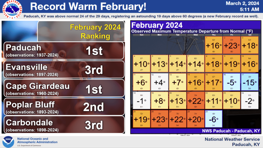
First, let’s take a look at February. Boy oh boy. Was it ever warm. These are incredible numbers.
If departures are two or three degrees above average, then we consider that a lot. February blew it out of the water.
These are some amazing stats.
Temperatures were well above normal by an astounding 8 to 9 degrees.
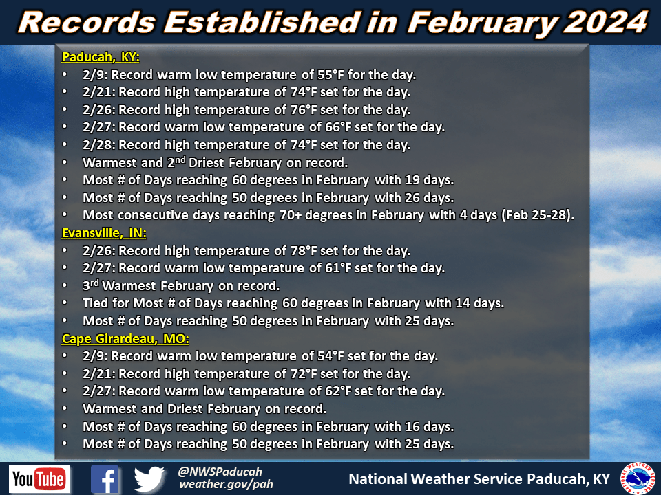
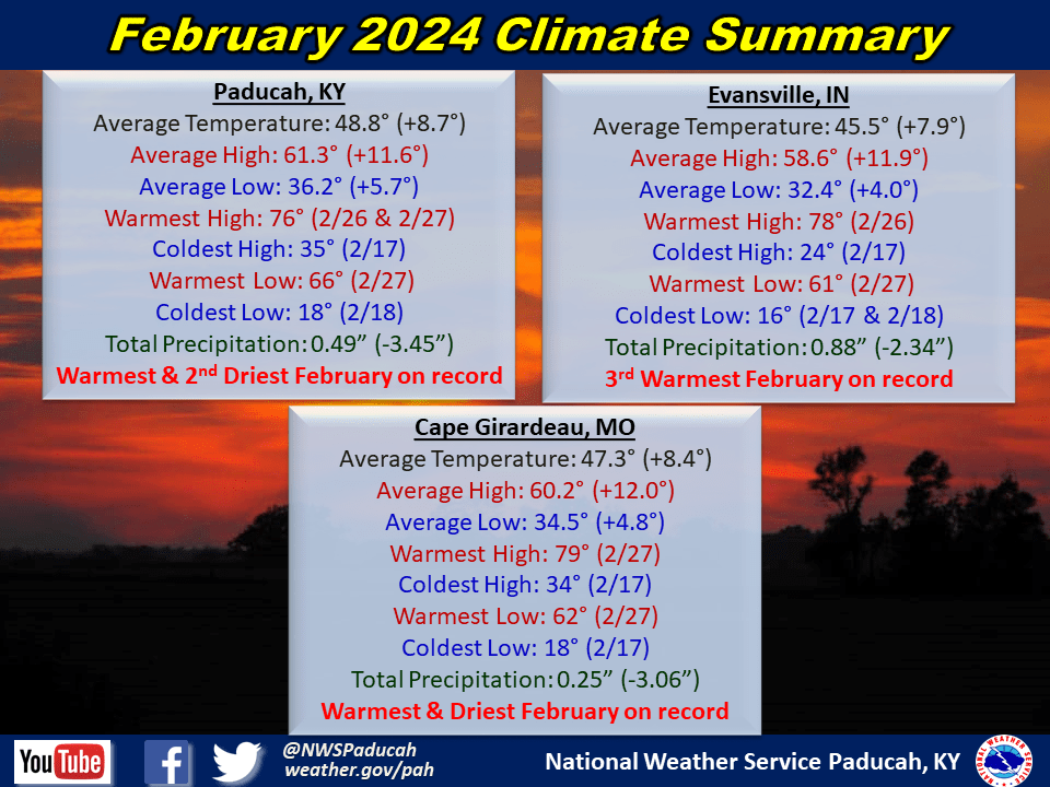
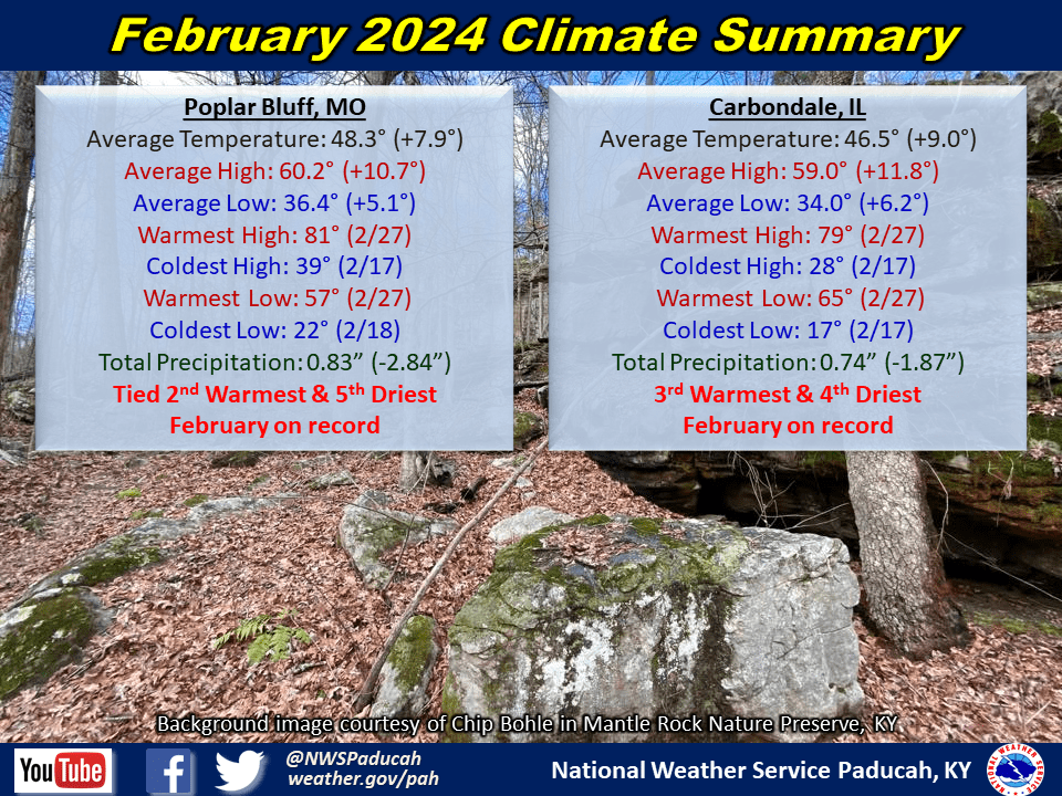
It was officially the warmest February on record in Paducah and Cape Girardeau, 2nd warmest in Poplar bluff, and 3rd warmest for Evansville and Carbondale.
High temperatures finished around 11 to 12 degrees above normal while low temperatures checked in 4 to 6 degrees above normal.
Depending on your location, there were only between 4 and 6 days during the month that finished below normal. Our brief cool spells were focused from February 16-19th and again on Leap Day (Feb 29th).
There were multiple stretches of well above normal temperatures with strings of highs in the 60s common. We started the month with 9 of the first 10 days reaching 60 degrees in Paducah.
A secondary surge around Valentine’s Day was followed by a brief cool-down thereafter. Most locations reached 70 degrees on the 21st and again from the 25th through 27th.
Paducah even registered 4 consecutive days reaching 70 degrees from the 25th through 28th. This broke the previous longest streak in the month of February which was 3 days.
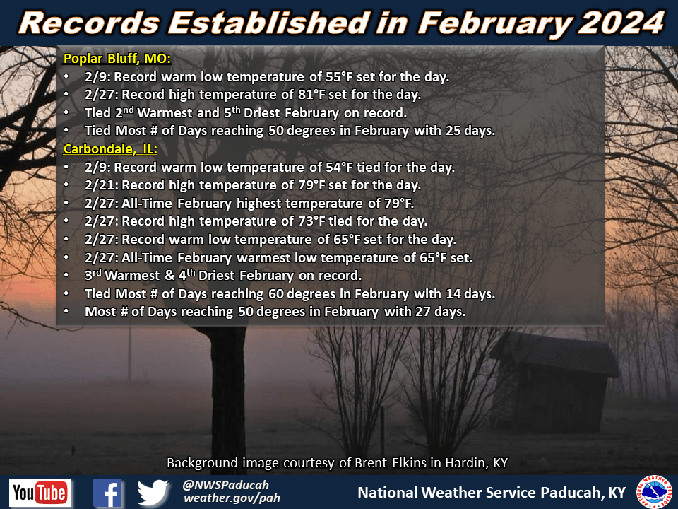
Cape Girardeau and Carbondale tied their February all-time warmest temperature on the 27th, both reaching 79 degrees.
Poplar Bluff was one of several locations in southeast Missouri that hit 80 degrees that day. In the Ozark Foothills, a dryline moved through allowing deeper mixing to occur and temperatures soared even further. The high temperature in Van Buren, MO reached 90 degrees, which is the highest February temperature on record at any location in our 58 county forecast area. The previous record was 88 degrees in Doniphan, MO back on February 13, 1962.
We ended the month with a sharply colder airmass with day-time highs only in the 30s and 40s on Leap Day (although daily high temperatures were actually in the 60s and 70s well before sunrise). Most locations observed a record setting number of days reaching both 60 and 50 degrees in the month of February.
Paducah had 19 days reach 60 degrees, breaking the previous record of 17 days set back in February 1976. We also had 26 days reach 50 degrees, breaking the previous record of 23 days set back in 1992.
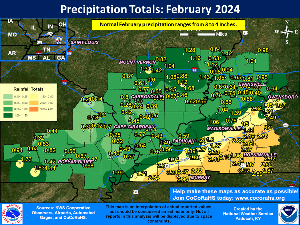
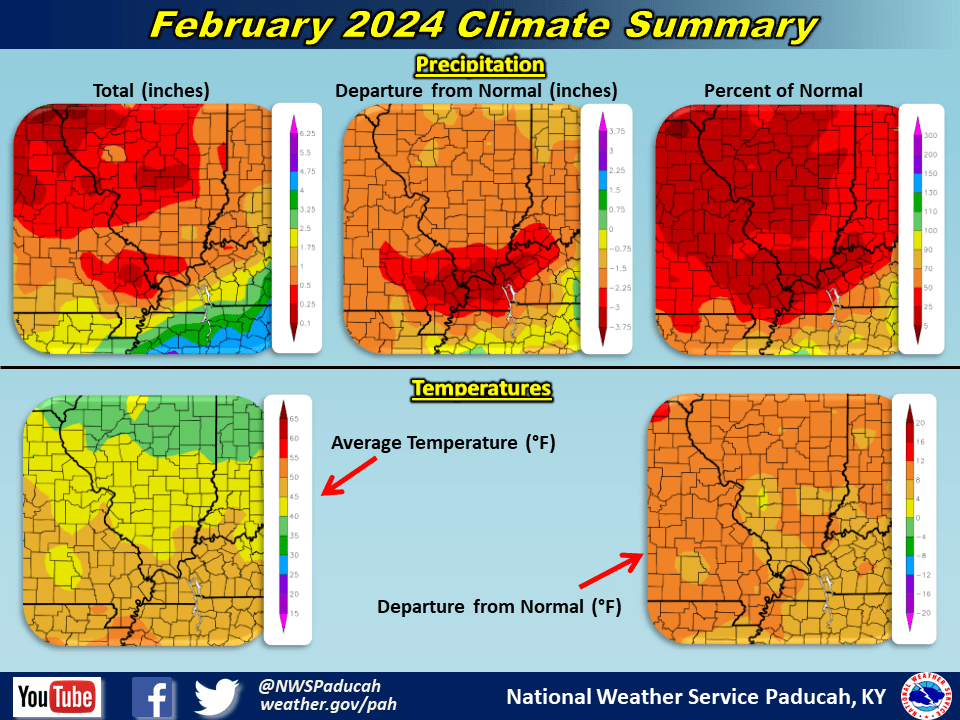
Along with the incredible warmth, it was a very dry month for most of our area. 4 of our 5 climate stations recorded one of their top 5 driest February’s on record.
Cape Girardeau finished as their driest February, only picking up 0.25”.
Paducah didn’t fair much better, only receiving 0.49” and clocking in as our 2nd driest February.
Most areas received under 2”, and there was a large swath of the region that only received between 0.25” and 0.75” across southeast Missouri, southern Illinois, southwest Indiana, and a few counties in far west Kentucky.
There was a swath of heavier precipitation ranging from 2 to 3” across southern portions of west Kentucky from Fulton to Murray to Hopkinsville and Greenville. Even this region was drier than normal for February though.
The highest observed amount was 3.24” at a CoCoRaHS station in southeast Graves County (5.6 miles south of Farmington).
Most areas received little in the way of snow accumulation. However, areas north of a Carbondale, IL to Evansville, IN line did receive some measurable snow on February 16th.
Thundersnow was reported up around Mount Vernon and Fairfield, IL. This lead to 1-2” per hour rates occurring which ended up producing a narrow swath of 4 to 7” along and north of the I-64 corridor in southern Illinois.
The graphic below is an interpolated monthly rainfall map using actual observations. Please note that there are likely discrepancies in between observations, since the values are estimated based on nearest reports.
February 2024 Review: Precipitation and Temperature Maps
Just amazing. We had one or two cool shots mid to late February.
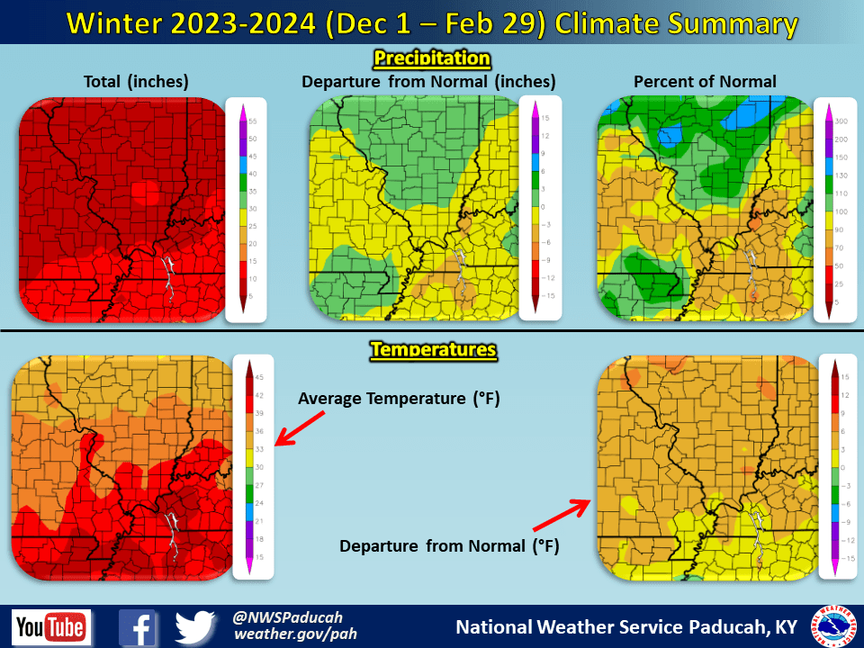
Let’s look at the winter as a whole.
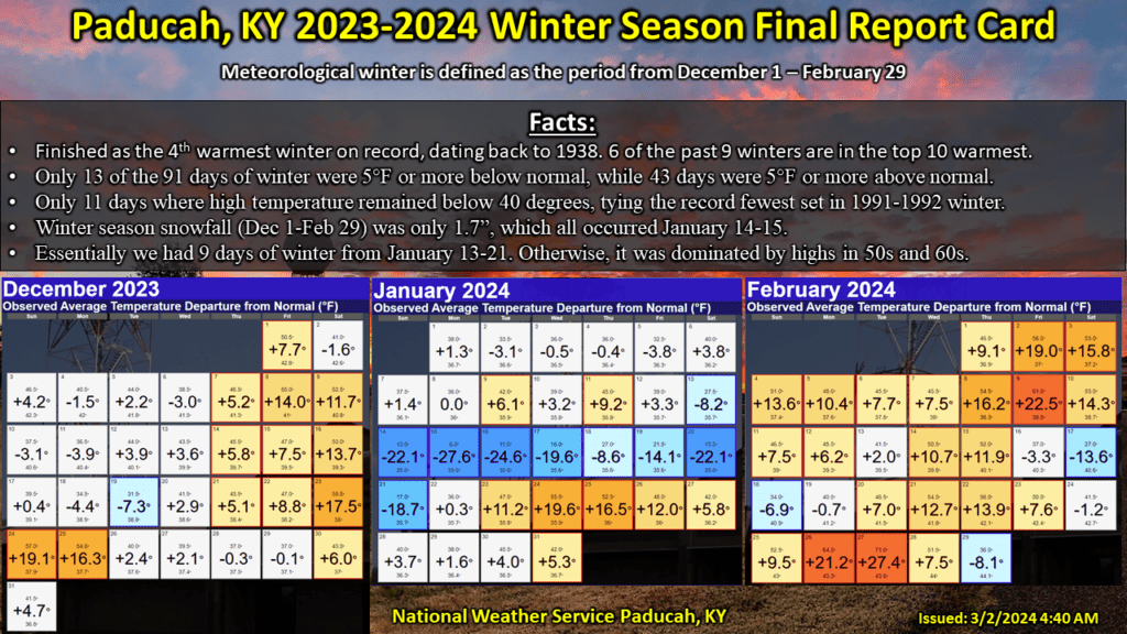
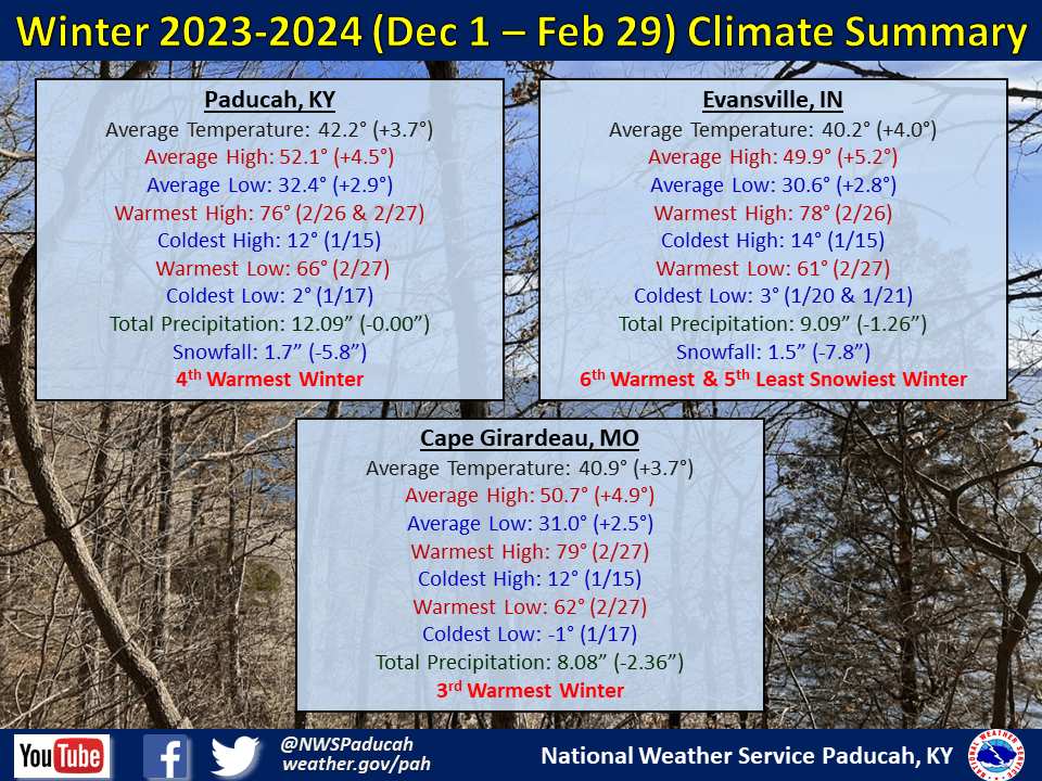
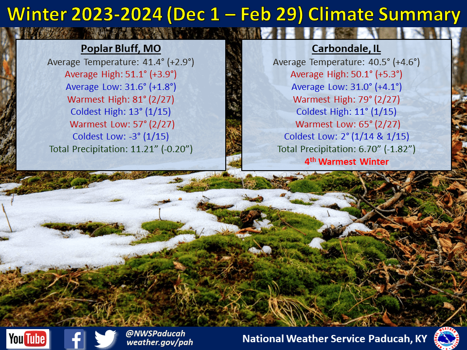
Temperatures were well above normal by 3 to 5 degrees. Cape Girardeau finished as their 3rd warmest winter, while Paducah and Carbondale observed their 4th warmest, and Evansville 6th warmest. December and February finished much warmer than normal, especially February which ranked amongst our warmest on record. January actually finished below normal by around 1 to 3 degrees, largely due to an arctic blast that impacted the area between January 13th and 21st.
We basically had 9 days of winter while the rest of the season was quite mild with only a few other brief cold shots.
Paducah registered 28 days reaching 60 degrees, which was the 3rd most on record (record is 31 days set in 2021-2022 winter).
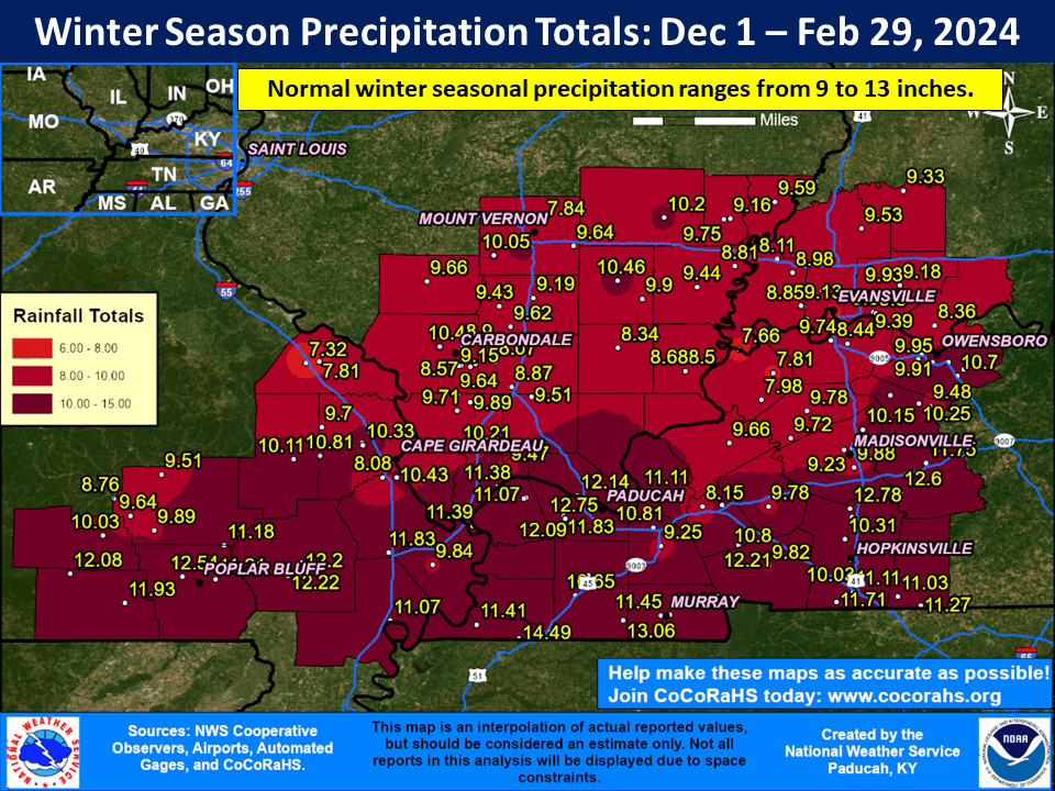
The winter season finished near normal or drier than normal across much of the region. Most locations received anywhere from 8 to 12” of precipitation, which was anywhere from right near normal to 1 or 2” drier than normal.
The highest reported amount was 14.49” at a CoCoRaHS station 5 miles west of Fulton, KY. Generally the southern portions of southeast Missouri and western Kentucky, closer to the Arkansas and Tennessee borders, received the heaviest amounts.
Snowfall was well below normal, with most areas only receiving amounts of 0.5” to 3”. The exception was a corridor of southern Illinois from Pinckneyville to Mount Vernon to Fairfield and Mount Carmel which picked up 4 to 7” thanks to thundersnow on February 16th.
Evansville only picked up 1.5” for the winter season, ranking as their 5th least snowy winter on record.
The graphic below is an interpolated rainfall map using actual observations. Please note that there are likely discrepancies in between observations, since the values are estimated based on nearest reports.
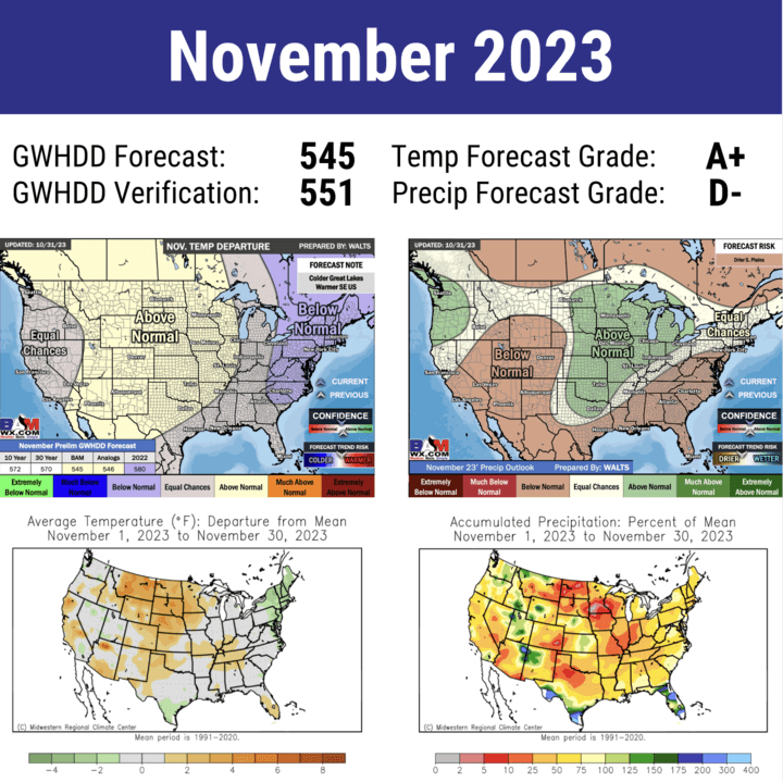
The www.weathertalk.com long range team grades for November through January. I don’t have February, yet.
You can subscribe to www.weathertalk.com at that link.