Posted by Chief Meteorologist Beau Dodson
Update Sunday morning.
Good day, everyone. A nice day on tap for the region. A bit breezy, at times. Higher winds arrive tomorrow.

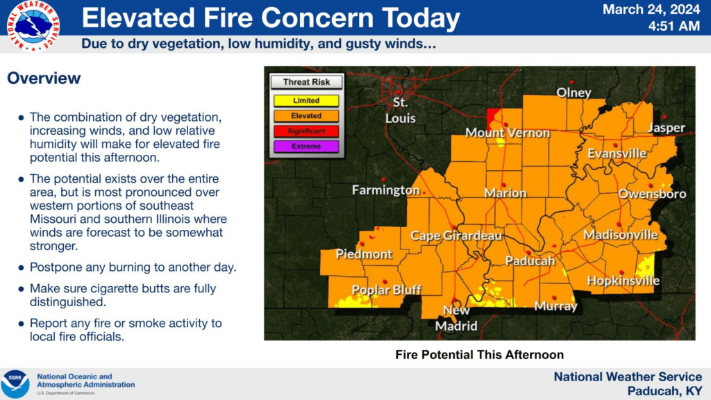
We do have an increased risk of field fires today. Use care and avoid burning brush and fields.
A widespread wind and rain event will impact the region Monday into Monday night. The rain may linger into Tuesday.
I am concerned about the tight pressure gradient over our region Monday into Monday night. A tight barometric pressure gradient usually means strong and gusty winds. In other words, a windy March day. Spring winds.
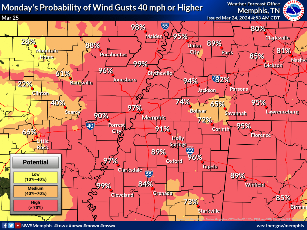
Wind gusts could exceed 40 mph and perhaps even 50 mph. We are still working out the details of the forecast, but let’s keep an eye on both Monday and Monday night for strong and gusty winds.
Here is some information from the Memphis, Tennessee, National Weather Service. The cover the Missouri Bootheel and northwest Tennessee. Scroll down for other areas.
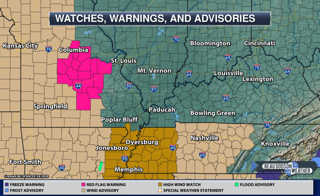
Bottom Line: A strong storm system will impact the Mid-South on Monday, resulting in a myriad of threats for the region. A High Wind Watch has been issued for the entire region from 7AM Monday to 1AM Tuesday.
Tomorrow, March 25:
- Several weather hazards will exist on Monday. Below is a bulleted list of hazards and expected impacts:
- High Winds – There exists increasing confidence for sustained winds of 40 mph on Monday, with the highest winds occurring in the evening hours. As the event nears, the aforementioned High Wind Watch will likely be upgraded to a High Wind Warning or downgraded to a Wind Advisory.
- Heavy Rainfall – The Weather Prediction Center has placed the majority of the Mid-South in a Slight Risk for excessive rainfall Monday. Overall precipitation totals have trended downwards, with up to 2 inches expected.
- Severe Weather – The Storm Prediction Center has placed a portion of the Mid-South in a Marginal and Slight Risk for severe weather Monday. This is a very low confidence event, but if enough surface instability is realized the severe threat will be greater. Damaging winds and heavy rainfall are the primary threats.
Confidence: Low (1/5) for severe weather impacts
Medium (3/5) for heavy rainfall impacts
Medium-High (4/5) for high wind potential


The National Weather Service may have to issue more wind advisory products.
The NAM model shows the highest winds Monday afternoon and night. Sometimes the NAM overestimates wind speeds, but you get the general idea. It could be quite windy along the cold front as it sweeps eastward across the region.

Again, as mentioned above, a high wind watch has been issued by the Memphis, Tennessee, NWS for the Bootheel and northwest Tennessee.
Additional counties may need to be added.
The Paducah, Kentucky, NWS issued this graphic.

In addition to the strong and gusty winds, We are forecasting a widespread shower and thunderstorm event. Locally heavy rain can’t be ruled out.
Timing of the rain from the Paducah, Kentucky, NWS.

Some locations could top an inch of rain. Most of which will fall Monday night. We are in drought and need the rain.
I am keeping a close eye on the severe weather threat, as well. For now, the Storm Prediction Center has not outlined our region for severe thunderstorms Monday or Monday night.
They do have a low-end risk Tuesday morning and early afternoon over portions of the Ohio Valley.
I will keep an eye on it. Here is their day three outlook. The dark green is where a few storms could be severe. It is possible this shifts east if the front speeds up just a tad.
The light green is sub-severe storms (lightning would be the concern there).

Instability is lacking, but wind shear is high. If the instability is slightly higher, then a few of the thunderstorms could produce high winds. The wind fields aloft with be unusually strong.
Here is the high resolution Hrrr future-cast radar model. What radar might look like Monday into Monday night.
This is in Zulu time. 12z=7 AM. 18z=1 pm. 00z=7 pm. 06z=1 am.

Here is the NAM model future-cast radar. What radar might look like Monday into Monday night.
This is in Zulu time. 12z=7 AM. 18z=1 pm. 00z=7 pm. 06z=1 am.
The brunt of the line of showers and storms will move through Monday night. Again, some of those thunderstorms could be gusty.

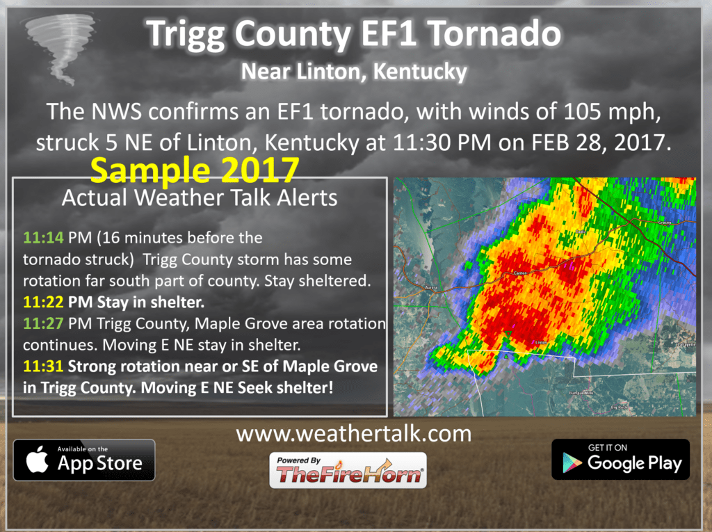
Want to receive more weather information? I provide a service through www.weathertalk.com
Subscribe at www.weathertalk.com and then download the Beau Dodson Weather app from the app stores!
Apple users: Beau Dodson Weather App
https://wtalk.co/9EZYG8A8
Android users: Beau Dodson Weather App
https://wtalk.co/ZEWYU8ME
Need help? Email me at beaudodson@usawx.com
* Daily weather forecasts
* My personal weather blog with all sorts of weather information!
* Special weather statements sent to the Beau Dodson Weather app.
* Rapid fire tornado alerts.
* Severe weather alerts and forecasts.
* Severe weather updates throughout the day (when severe weather is occurring)
* Ice storm alerts and forecasts.
* Winter storm alerts and forecasts.
* Winter storm updates throughout the event.
* Regional weather videos.
* Long range weather videos.
* A daily forecast that I hand type for your county. Sent out every afternoon.
* Long range outlooks. Including week one, two, three, four, and monthly outlooks. Seasonal outlooks.
* App messages to alert you when I have updated the weather blogs and Facebook.
* And more!
Here are some examples of what people receive when they subscribe to www.weathertalk.com