Posted by Chief Meteorologist Beau Dodson
Want to receive more weather information? I provide a service through www.weathertalk.com
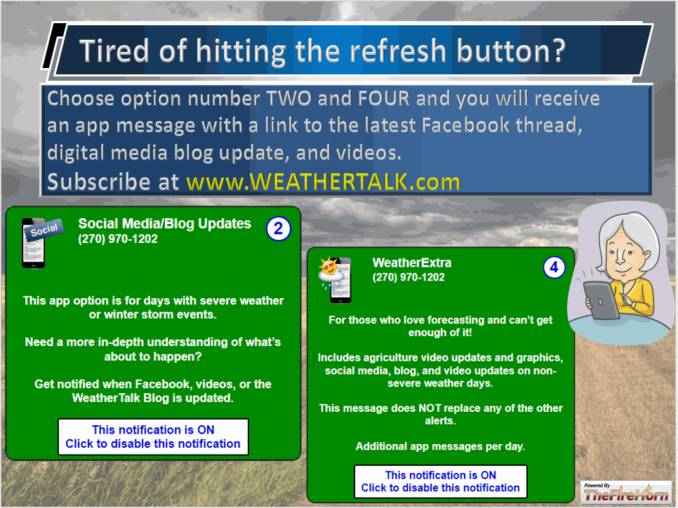
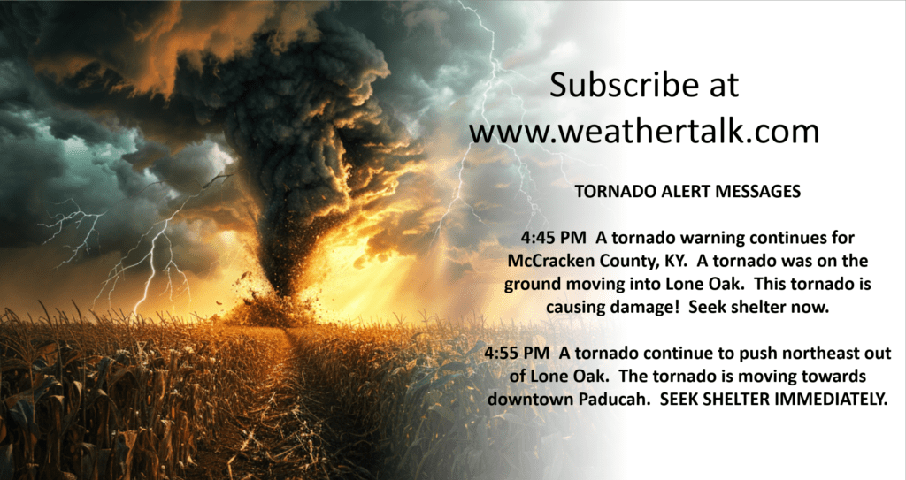
Subscribe at www.weathertalk.com and then download the Beau Dodson Weather app from the app stores!
Check out our live exclusive weather radars.
Interactive local city-view radars. Clickable watches and warnings.
https://beaudodsonweather.com/weather-radars/
** Severe Weather Event Increasingly Likely **
The concern?
Damaging wind and golf ball size hail. A few tornadoes can’t be ruled out, as well. Locally heavy rain and lightning.
When?
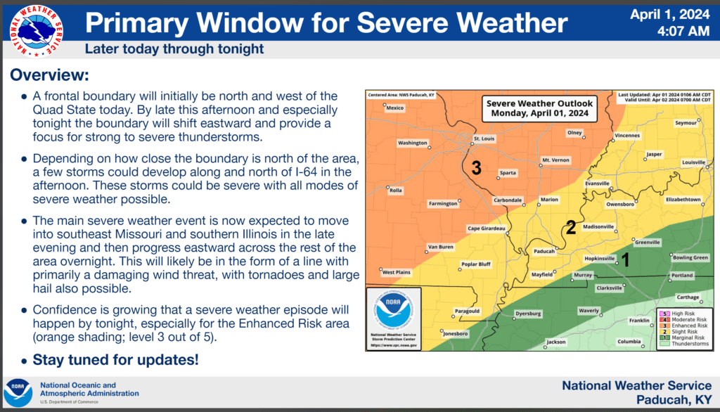
We are focused on Monday night into the wee early morning hours of Tuesday. Peak time-frame will be 10 PM tonight to 2 PM Tuesday. Some of the thunderstorms may continue into Tuesday afternoon over southeast Illinois, Kentucky, and Tennessee.
The risk will first arrive over southeast Missouri and northern portions of southern Illinois tonight into the morning hours.
It will then move east across the region late tonight into tomorrow.
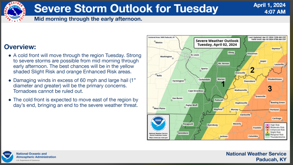
A second round of storms will develop Tuesday mid to late morning into the afternoon hours. That round would mainly be southern Illinois into Kentucky and Tennessee. More likely east vs west. Some of those storms could be severe, as well.
Where?
See the graphics. There is a risk area-wide later today/tonight into tomorrow morning. Then, the risk shifts a bit more east tomorrow.
Certainties
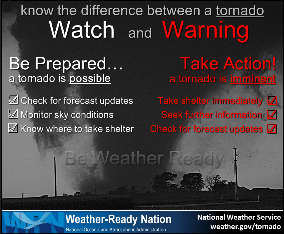
Thunderstorms will occur. Some will be severe. Severe thunderstorm and/or tornado watches will be issued. Some warnings will be issued.
Uncertainties
There are questions about the exact timing county by county. Models are not handling this situation very well. It appears a few storms could develop as early as this afternoon over our northern counties, but most likely the bulk of this event will be very late tonight into Tuesday morning.
There are questions about coverage. Some data shows a line of storms moving into the region late tonight, but then it falls apart leaving a boundary. New storms form along the boundary tomorrow.
Other data shows a solid line of storms sweeping across the entire region.
Confidence in the coverage is lower than usual. Monitor updates.
Call to action
Make sure you have 3 to 5 ways of receiving severe weather information.
The www.weathertalk.com Beau Dodson Weather app is one of those ways.
We have a new service that CALLS your home phone of cell phone if you house is in a tornado or severe thunderstorm warning. You can subscribe to that here https://weathercallservices.com/beau-dodson-weather
I have partnered with WeatherCall to bring you this service.
A weather radio is a great source of weather information.
Other local television weather apps.
Make sure your WEA is on. Google Android or Apple WEA severe weather alerts. How to turn on my WEA. Google that.
Outdoor sirens can be a source for those outside.
Forecast Discussion.
The risk of severe weather continues to increase Monday afternoon and especially Monday night.
We are in a level one, two, and three risk across the region.
I encourage you to not get caught up in the colors. Weather doesn’t always follow our nicely drawn maps and color grids.
A tornado in the level one zone is the same as a tornado in a level three zone. The damage is the same. Thus, let’s not focus on the colors. Focus on the forecast.
Most of our regions EF3 and greater intensity tornadoes have occurred in level one, two, and three risks.
The forecast is for severe thunderstorms to develop Monday afternoon into early Tuesday morning. Tornadoes, damaging wind, and large hail will be a concern.
If supercells form, then some of the hail could reach golf ball size or perhaps even larger.
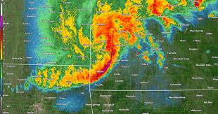
Supercells tend to be scattered vs a solid line of storms. A solid line of storms would be more likely to produce damaging wind and short-lived tornadoes.
A squall line looks like this
Supercells look like this. Discrete.
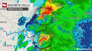
Supercells tend to produce longer tracked tornadoes, higher damaging wind gusts, and larger hail.
Early on, supercells appear possible. Then, a line of storms should form.
The bulk of our regions tornadoes occur in level one, two, and three risk zones. So, again, don’t get too caught up in the colors.
The color levels are good for guidance, but don’t tell the entire story. I try to remind everyone of this during every event.
For example, the Harrisburg EF4 tornadoes, several years ago, was in a level two risk. A slight risk.
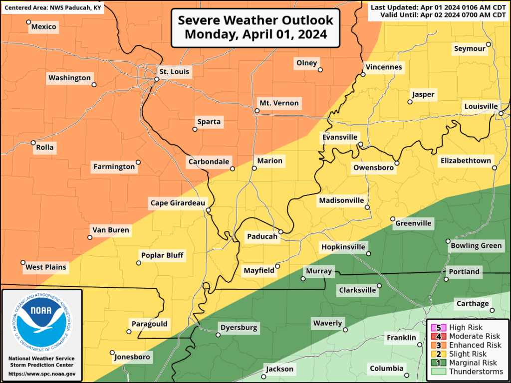
Graphic one shows you the Storm Prediction Center’s official severe weather outlook. Adjustments are still possible. They have changed this outlook three times in the last 24 hours.
Which is one more reason not to get too caught up in the colors.
If storms train over the same area, then some brief flooding concerns could develop. Avoid flooded roadways, as always.
There will be quite a bit of wind shear aloft with this event. Wind shear is the turning of wind with height and the increase in wind speed with height.
This is an ingredient for severe thunderstorms.
Dew points will rise into the 60s. That is plenty of moisture for severe thunderstorms to tap into.
CAPE values (instability) will rise into the 500 to 1500 range Monday afternoon and evening.
All of those are ingredients for severe weather.
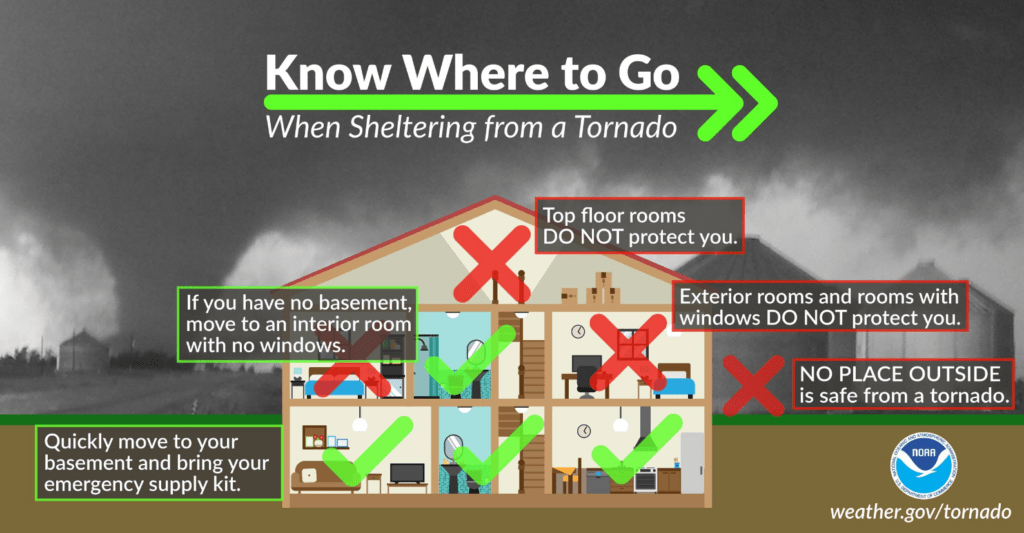
The Paducah, Kentucky, National Weather Service made the fifth graphic.
Double click graphics to enlarge them.
Want to receive more weather information? I provide a service through www.weathertalk.com
Subscribe at www.weathertalk.com and then download the Beau Dodson Weather app from the app stores!
Apple users: Beau Dodson Weather App
https://wtalk.co/9EZYG8A8
Android users: Beau Dodson Weather App
https://wtalk.co/ZEWYU8ME
Need help? Email me at beaudodson@usawx.com
* Daily weather forecasts
* My personal weather blog with all sorts of weather information!
* Special weather statements sent to the Beau Dodson Weather app.
* Rapid fire tornado alerts.
* Severe weather alerts and forecasts.
* Severe weather updates throughout the day (when severe weather is occurring)
* Ice storm alerts and forecasts.
* Winter storm alerts and forecasts.
* Winter storm updates throughout the event.
* Regional weather videos.
* Long range weather videos.
* A daily forecast that I hand type for your county. Sent out every afternoon.
* Long range outlooks. Including week one, two, three, four, and monthly outlooks. Seasonal outlooks.
* App messages to alert you when I have updated the weather blogs and Facebook.
* And more!
Here are some examples of what people receive when they subscribe to www.weathertalk.com
We send out app notifications when we update the social media posts (Blog, Facebook, other)