Posted by Meteorologist Beau Dodson
Want to receive more weather information? I provide a service through www.weathertalk.com
Subscribe at www.weathertalk.com and then download the Beau Dodson Weather app from the app stores!
Apple users: Beau Dodson Weather App
https://wtalk.co/9EZYG8A8
Android users: Beau Dodson Weather App
https://wtalk.co/ZEWYU8ME
Need help? Email me at beaudodson@usawx.com
A light wintry precipitation event is likely Thursday into Friday morning.
Our deadliest winter storms are light freezing drizzle/freezing rain events.
My biggest concern, for this event, will be trace amounts of ice on very cold roadways.
Temperatures Thursday may briefly approach or go above freezing, but surfaces will remain cold.
If ANY freezing rain or sleet develops, then roadways could become a skating rink quickly. Especially the less traveled roads.
There are two systems moving into the region.
A new arctic blast of air moves in from Canada tomorrow night into Friday.
Wind chill values Friday night will dip into the -5 to -20 degree range.
Temperatures will remain very cold through Saturday night.
That front will bring snow showers with 0 to 1″ of fresh snow.
A second system will move into the region from the southwest. That precipitation event will develop late tonight into Thursday morning. This will linger into Thursday evening.
It is possible that some counties receive little or no precipitation. Keep that in mind.
The biggest concern for light freezing rain and sleet will be from northeast Arkansas, the Missouri Bootheel, extreme southern Illinois, western Kentucky, and northwest Tennessee.
Snow chances will be higher across northern portions of southeast Missouri and then into southern Illinois. That will eventually track into western Kentucky, as well.
Monitor updates. For planning purposes, plan on icy roadways redeveloping tomorrow into Friday morning.
Let me show you a couple of graphics. This won’t be exact, but I wanted to give you an idea on placement.
Light snow totals of 0 to 1″ will be possible Thursday into Friday morning. The snow will approach the region from the northwest and move southeast.
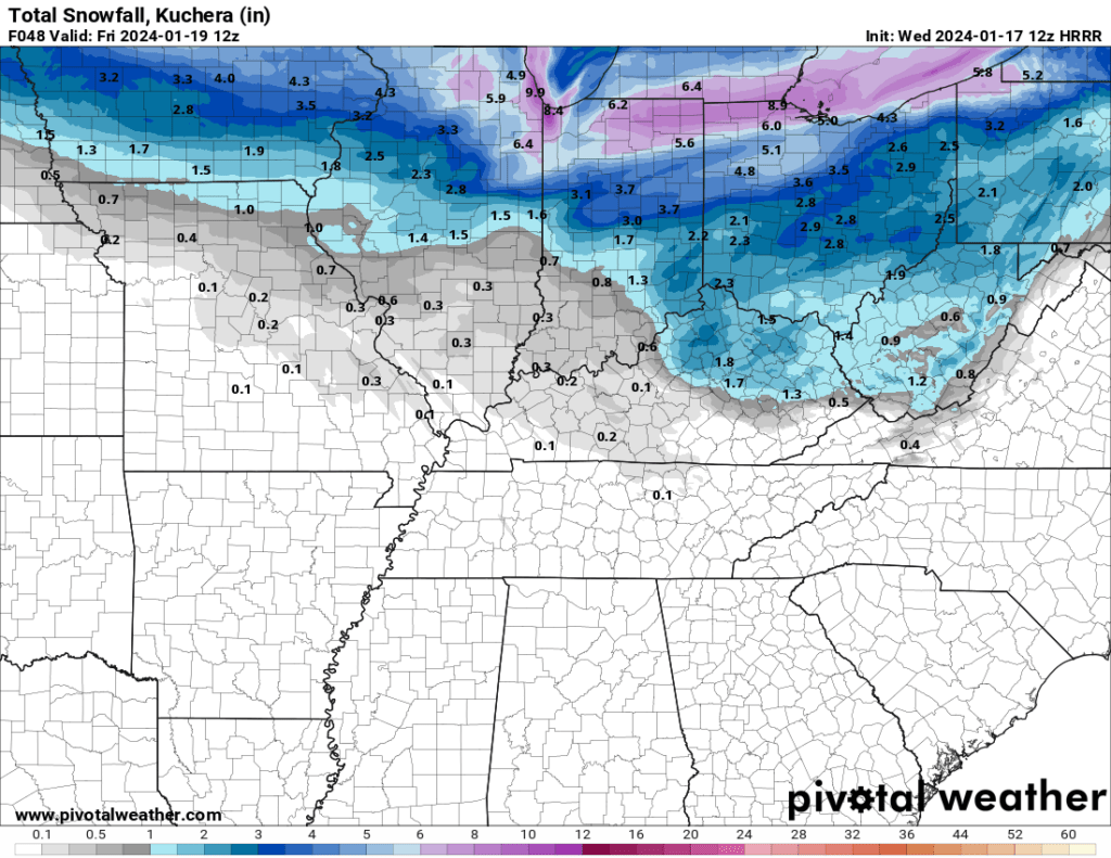
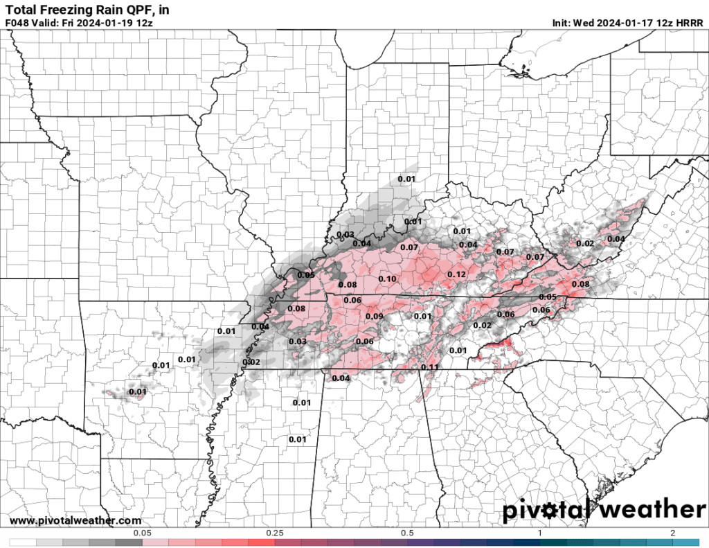
Here is the Hrrr model. This is where it paints freezing rain and sleet. Again, this won’t be exact, but you get the general idea. That type of precipitation is more likely over our southern and eastern counties.
Focus isn’t on totals. Focus is on impacts. Any freezing rain or sleet could cause significant travel issues. Especially on untreated roadways or secondary roadways.
Want to receive more weather information? I provide a service through www.weathertalk.com
Subscribe at www.weathertalk.com and then download the Beau Dodson Weather app from the app stores!
Apple users: Beau Dodson Weather App
https://wtalk.co/9EZYG8A8
Android users: Beau Dodson Weather App
https://wtalk.co/ZEWYU8ME
Need help? Email me at beaudodson@usawx.com
* Daily weather forecasts
* My personal weather blog with all sorts of weather information!
* Special weather statements sent to the Beau Dodson Weather app.
* Rapid fire tornado alerts.
* Severe weather alerts and forecasts.
* Severe weather updates throughout the day (when severe weather is occurring)
* Ice storm alerts and forecasts.
* Winter storm alerts and forecasts.
* Winter storm updates throughout the event.
* Regional weather videos.
* Long range weather videos.
* A daily forecast that I hand type for your county. Sent out every afternoon.
* Long range outlooks. Including week one, two, three, four, and monthly outlooks. Seasonal outlooks.
* App messages to alert you when I have updated the weather blogs and Facebook.
* And more!
Here are some examples of what people receive when they subscribe to www.weathertalk.com